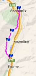
D207 Aiguebelle - St Pierre de Belleville(sh)

This little summit is on a shoulder of Col du Grand Cucheron. It's part of a signed bike route on the south side of the Arve Valley
1.(370m,00.0km) START-END SOUTH: low point on D207, south of St Pierre de Belleville
2.(510m,03.2km)road on left goes to Col du Grand Cucheron
3.(600m,05.1km)TOP: point of highest elevation
4.(320m,10.4km)START-END NORTH: Aiguebelle
 

Approaches

From South.
Following the bike route in St Pierre the signed "boucle" traverses up a shoulder of the Chne. de Belledonne in a straight line. Surprisingly it keeps on climbing even after the junction with the road to Col de Grand Cucheron.

From North. (described downwards) The road stays in cool shade, and once in a while permits a view onto opposing peaks around Grand Arc (2482m), before bike traffic is discharged into the Isere Valley

A Day on a Tour:

COMPLETELY PAVED:

( < Col du Mt Cenis | Mont Saleve northern summit > )
D207 St Pierre de Belleville- Aiguebelle(sh): St Jean > St Pierre de Belleville > D207 St Pierre de Belleville- Aiguebelle(sh) > Aiguebelle > Montmelian > La Ravoire: 50.1miles with 2130ft of climbing in 4:28hrs (VDO MC1.0 m4:14.6.26)

Dayrides between this day and the next touring day (with different start and end points) over a pass are on pages:

1. from la Ravoire (near Chamberry):

Col du Cucheron
Col du Lindar
Col du Grand Cucheron
Col de Coq
D42 Belvedere du Mont du Chat s(u)
Col de la Cluse
Col de Plainpalais

2. from Methed (near Annecy)

Col de la Forclaz

-


advertisement

advertisement