| |
| |
Col Du Lindar
This is not an area where you
really have to get away from traffic, because
there is not much in the first place. But if that
is still too much, this pass with a short unpaved
section over the top will do the trick. All I saw
and heard over the top was cows and one
motorcycle, with the engine turned off while
coasting downhill
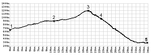
From South. (described
downwards). The road continues by making a right
turn. But the way back down is a narrower path,
which is accessed by staying left. The closest
thing to a far view does not last long. It shows a
box shaped cliff of the Chartreuse across an
expanse of needle trees. The path becomes wider
and winds down through the trees. This forestry
road can be very muddy if it rained recently. It
is much too rocky for a road bike, but short
enough so that it easily walked. Road conditions
improve after a few hundred meters and a gravel
road deposits the rider on the top of Col Du Marocaz.
The profile continues down the steep side of the
pass to St Lauren and Montmellian. On the lower
part the forest draws back numerous times to
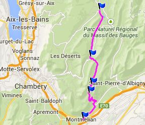
reveal fine views of the Massif de la Vanoise. 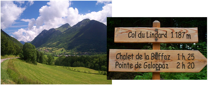 History: In 1940 a forest road was built to connect the top of Col du Marocaz with Aillons. The idea was that the village La Thuile could have better access to wood from (or closer to) the valley. But the pass was only rarely used for that. Dayride with this point as highest summit: PARTIALLY PAVED / UNPAVED: Col Du Lindar , Col Des Pres : La Ravoire (east of Chanbery) > up D21 > Boiserette > Le Bois > up D206 > Col des Pres > Allion Le Jeune > up D32A <> out and back towards Praz Geraz, Chateau de la Fullie >> Col du Lindar > Col Du Marocaz(shp) > Montmelian > Francin > Le Marche > back to starting point in La Ravoire: 43.0miles with 5260ft of climbing in 4:58hrs (Garmin etrex 30 m4:14.6.30) The last day with different start and end points over a pass on this tour is on page: D207 Aiguebelle - St Pierre de Belleville(s)
|
|
|
advertisement |
|
|
advertisement |