| |
| |
Col de la Forclaz
There are three passes with this
name, that even I know, which means there are most
likely even more than that. This particular one is
memorable because of a very steep southern
approach, nice views of Lac D'Annecy on the
northern approach, and in my case a very rainy,
cold day in July.
A sign advises motorists to leave 1.5m between
them and a cyclist, and all the ones I met, did.
Regularly occurring views of the lake measure the
progress upwards. The road retreats from the lake
for a while, only to return to it, with a view
from straight above. The top has many buildings
and a tourist office, restaurant, bar etc, that
are suspicious of some major tourist attraction
nearby. But it just seems to be the junction with
a one way road up to Les Prets Ronds (1211m) and
onwards to a trail up Col de l'Aulp. From South. (described
downwards). The road goes through the village
Montmin, which to my eyes has a Swiss appearance:
elaborate houses with detail oriented wood
construction and a solid appearance - the opposite
of a stage set - something that is meant to remain
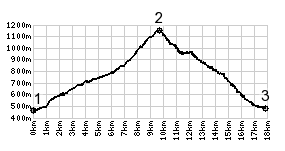
after the movie is over. From the profile it looks
like the steep section is mostly on the northern
side. The steep grades may be less sustained on
this side. But I remember them more: the sign says
13%. But there are no views of the lake. By now
you are already south of it in Montmin. At the
bottom waits an immaculately paved "piste
cyclabile" in both directions. It looks that like
it must be an old railbed, because it is entirely
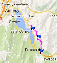
separate from the road. 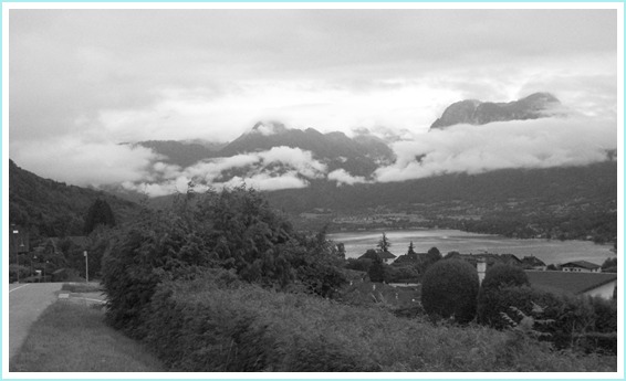 Dayride with this point as highest
summit: Col de la Forclaz , additional out and back:
Meythet > Annecy > Annecy Le Viex >
Veyrier du Lac <> short out and back in
direction Col de Bluffy >> Menthon Saint
Bernard > Montmin > Piste Ciclabile on east
side of lake north > Annecy > back to
starting point in Meythet with many miles of
detours to take advantage of time when it was not
raining or only raining slightly: 46.4miles with
2950ft of climbing in 4:25hrs (VDO MC1.0
m4:14.7.11)
|
|
|
advertisement |
|
|
advertisement |