| |
| |
Col du Mont Cenis 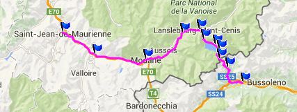 There are so
many great passes in the alps to cycle over, that
it's understandable that with time, you get some
of them mixed up. But it is unlikely that one
would mistake a ride over Mount Cenis Pass with
any other ride still in memory. This one is just
too different, and that's what makes it unique and
memorable. The top is not a knife edge, but a
large plateau stretching to distant snowcapped
mountain walls. I imagine one could make a film of
central Mongolia here. Mountain peaks play the
distant part in this movie. Closer to the road is
a large water reservoir with all its civil
engineering ornamentation. And last but not least,
there is the size of the climb from Susa - large -
very large. There are so
many great passes in the alps to cycle over, that
it's understandable that with time, you get some
of them mixed up. But it is unlikely that one
would mistake a ride over Mount Cenis Pass with
any other ride still in memory. This one is just
too different, and that's what makes it unique and
memorable. The top is not a knife edge, but a
large plateau stretching to distant snowcapped
mountain walls. I imagine one could make a film of
central Mongolia here. Mountain peaks play the
distant part in this movie. Closer to the road is
a large water reservoir with all its civil
engineering ornamentation. And last but not least,
there is the size of the climb from Susa - large -
very large.
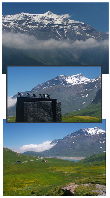 From East. The icy alpine
peaks in the French alps fall off very steeply
towards Italy and the Susa valley. It's a special
day if you can see these mountains it their
totality, when looking up at this ice crowned wall
from Susa. Almost always, there are some clouds
somewhere, highlighting a section of the wall,
while obscuring another. From East. The icy alpine
peaks in the French alps fall off very steeply
towards Italy and the Susa valley. It's a special
day if you can see these mountains it their
totality, when looking up at this ice crowned wall
from Susa. Almost always, there are some clouds
somewhere, highlighting a section of the wall,
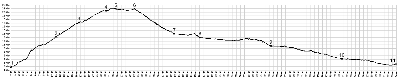
while obscuring another.Climbing up towards this wall on a bicycle, first of all involves a lot of forest. It's difficult to gauge where you are in the big scheme of things, that is - getting to the top of this pass. Over there behind the trees is still that wall, sharp peaks above parted from the rest of the landscape by a solid layer of clouds in the middle. But there comes a point in time, not long after the junction with the SP212 Moncennisio shoulder summit route has joined the main road, that first signs of a lake become evident. Not the lake itself, but just a lower spillway with many old official looking structures around it. The road markers also take on size and proportion that speaks of national pride and national interest. Cars are mere bugs compared to these guards of the mountains. After relaxing for a short time, while the road follows the spillway, a dam becomes visible, and the next section of the climb takes place on a few regular ramps, with lots of brickwork in form of walls and arches, again adding to the celebratory nature of this scene. The mountains do what they have always done, the vertical part. Reaching the last part of the switchbacks I am again looking forward to relax a little bit, while the road might follow the peaceful shores of this lake. Wrong again. - The road turns back east and climbs higher above the lake. Passing a few auberges, it also becomes evident, that I crossed into France long before reaching the lake. The road does finally follow the north shore, but high above it. Then I ride over the highest point on the route, and actually have no idea that this is it. Following the ups and downs along this vast lake, in above the trees tundra, you reach a concrete teepee, standing in a large parking lot, filled mostly with motor cycles. Here they sit and drink away the time, served by a few "wilderness stripmall" businesses, housed in government concrete. The vastness of this tundra plain with its distant wall of high peaks, is what makes this place special. A few more restaurants/bars follow. The official pass is located at the exit of this vast plain. Three relief monuments allude to the long history of travelers, that have crossed this pass - this is the short version. First there were the elephants, you have to imagine Hannibal with them. Pictured on the second monument: then came the armies. Trying to differentiate between them all would require a lot more space than one relief. There are just too many. And the on the third relief: cyclists, standing in the pedals and giving them all they got, armies of cyclists now flood the top of Mount Cenis Pass. From West: Since I had no
indication that the unlikely spot along the lake
would be the highest point, I was very surprised
to find these switchbacks actually going down.
From my map without contour lines, I had
expected them to go up. From the route along
lake it looks entirely plausible, that more
climbing is to be done behind it. But then, even
more surprising, even the descent is short.
Lanslebourg appears just after a short distance.
Compare that to the Susa ascent, where I didn't
see signs of levelness for much longer than my
panniers felt comfortable. And so the day was
not that long after all. A Day on a Tour: ( Passo di Gavia | D207 St Pierre de Belleville- Aiguebelle(sh) > ) Col du Mont Cenis , SP212 Moncenisio(sh) : Susa > Venaus > Novalesa > SP212 Moncenisio(sh) > Co du Mont Cenis > Lanslebourg <> out and back weekend shopping trip to next town donwvalley: 43.8miles with ft of climbing in 5:44hrs Dayrides between this point and the next summit ride with different start and end points, St Jean Maurienne are on pages: Col de l'Iseran
|
|
|
advertisement |
|
|
advertisement |