Belvedere du Mont du Chat
Each of the long sides of Lac du Bourget has a
popular cycling summit. Their altitude difference
is less than 50 meters. This point on the west
side of the lake is a real work out ride. It is a
sustained climb without a single flat spot and
little reason to get off the bike until the top is
reached. Many publications extol on the difficulty
of this climb. But then - not everybody has to race
up it.
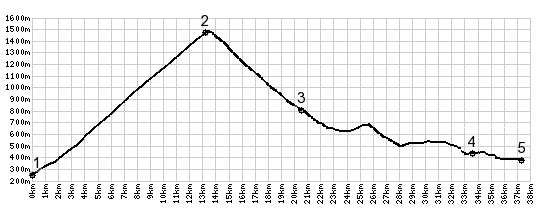 |
1.(250m,00.0km)
START-END EAST: Le-Bourget-Du-Lac:
jctD14-D42
2.(1504m,13.1km)TOP: D42 Belvedere du Mont
du Chat
3.(790m,20.2km)jct with D42A on left,
shortest way to Col De L'Epine
4.(440m,33.1km)START-END WEST: Novalaise
5.(370m,36.8km)START-END WEST: low point
on Lac Aiguebelette
|
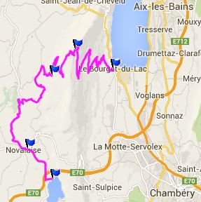 Approaches Approaches
From East. When
arrinving in Lac du Bourget on the bikepath along
the lake, there are signs for the tour named "dent
du Mont du Chat". That signals the start of the
climbing. The first switchbacks are just a village
block away and signs point the way. This road is
medium narrow and gets little traffic. The first
time the trees break open, you get a view of the
east end of the the lake together with its
airport. Then comes a long workout, gauged by road
signs, that signal progress with the current
altitude and the grade for the remaining distance.
As interesting as these signs are, they all read
10 percent (more or less by a degree or two), and
the grade is indeed very uniform.
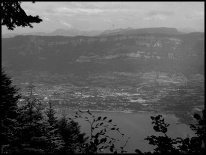
Then on top is another view from basically the
same geographical position - just higher. Now the
view reaches from the high peaks of the Belledonne
Range, over the sheer cliffs of northern
Chartreuse, to more snowy peaks peaks behind Mt
Revard on the other side of the lake - if the
weather is clear. More often than not, it is hazy
in the summer. A painted sign at the lookout
identifies probably around 50 peaks. There is also
a transmission facility as well as an eating /
drinking facility.
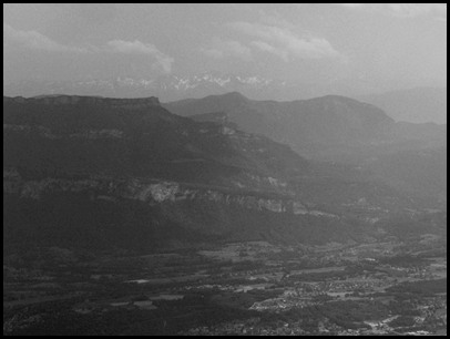
 From West. (described
downwards). After a switchback or two, the
corresponding lookout onto the western side
appears next to the road. The difference in
landscapes is striking. On this side low flowing
hills reach across the river Rhone in the disance
like gentle waves in an ocean with moderate to
gusty winds. By most definitions these small hills
still belong to the alpine area - or prealps - as
this area is sometimes called. By most people's
definitions the Jura Mountains start on the other
side of the Rhone, even though these foothills
have more in common with the Jura. From West. (described
downwards). After a switchback or two, the
corresponding lookout onto the western side
appears next to the road. The difference in
landscapes is striking. On this side low flowing
hills reach across the river Rhone in the disance
like gentle waves in an ocean with moderate to
gusty winds. By most definitions these small hills
still belong to the alpine area - or prealps - as
this area is sometimes called. By most people's
definitions the Jura Mountains start on the other
side of the Rhone, even though these foothills
have more in common with the Jura.
After that there are few, if any views until the
valley is almost reached, and a decision has to be
made between Vertemex and Truet. My route turned
left, direction Col
de l'Epine, so the the profile continues to
a low point in Novalaise
 History-Cycling: The climb
from the lake was only once part of a Tour de
France stage in 1974. History-Cycling: The climb
from the lake was only once part of a Tour de
France stage in 1974.
Dayride with this point as highest summit:
D42 Belvedere du Mont du Chat s(u) , Col de l'Epine
: la Ravoire > Chanbery with several km of
detours > bike path to Lac du Bourget > up
D42 > D42 Belverdere du Mont du Chat >
Vertemex > Novalaise > Col de l'Epine >
Chanbery > back to starting point in la Ravoire
with detour: 55.4miles with 6656ft of climbing in
5:56hrs (Garmin etrex 30: m4:14.7.4)
The last day with different start and end points
over a pass on this tour is on page: D207
Aiguebelle - St Pierre de Belleville(s)

|