|
|||||||||||||||||
|
|
|||||||||||||||||
| |
|
Mont Saleve - northern summit
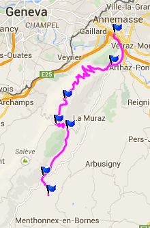
Mont Saleve is the prominent 18km long, bread loaf shaped
ridge south of Geneva. One paved, named pass crosses it: Col
de la Croisette. Another road crosses the pass at its
summit, and leads to higher summit points in both
directions. This northern summit is the lower of the two,
and the one with all the good views on Geneva.
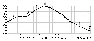
The last two km before the pass are somewhat steeper and
involve a few switchbacks in the forest. Col de la Croisette has
a small village, though I didn't check for the Mairie House and
the WW1 memorial. Technically it may just be a collection of
restaurants and businesses. The profile turns right and the trees get ever scarcer, until
the road reaches a high point at a picnic table and a high
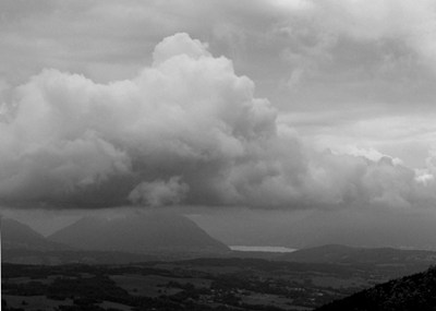
panorama point. According to the sign, I should be able to see a
piece of Mont Blanc in the middle. On the right I should see Lac
d'Annecy, where I had started the day. That part I even say
during bad weather. On top of it was a triangular cloud even
larger than Mt Blanc. But there was no chance of making out the
Belledonne Range, or signs of the Chartreuse, areas that I had
explored on my bike during the weeks before. Instead I watch
Japanese tourists practice American baseball next to the road.
Apparently they had some time to kill before the flight back
home from the Geneva airport.
From West. (described downwards) But rolling down the
first few switchbacks, there is a second viewpoint, a kind of
consolation price because I lost the big one: a viewpoint over
Geneva, that delivers great views even during the weather I had.
Tourists pay much money to take the cable car up here. Down
below the symbol of Geneva, the fountain in the Rhone, splashes
water into the sky, but only the "still very far
below" part of the sky. The rest of the way down consists
of many switchbacks, mostly forested, and also a second
viewpoint over Geneva, a little further down. (< D207 Aiguebelle -
St Pierre de Belleville(sh) |) Pictures to the right: Dayrides from the endpoint of this day are on pages: Col du Perret
|
|
|
advertisement |
|
|
advertisement |