|
|||||||||||||||||
|
|
|||||||||||||||||
| |
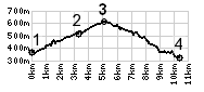
1.(370m,00.0km) START-END SOUTH: low
point on D207, south of St Pierre de Belleville
2.(510m,03.2km)road on left goes to Col du Grand Cucheron
3.(600m,05.1km)TOP: point of highest elevation
4.(320m,10.4km)START-END NORTH: Aiguebelle