| |
| |
Venta la Nades s(u)
This is probably the nicest climb
from Malaga Centro. A number of different
approaches lead here and to nearby Puerto de Leon.
During the ride over Venta La Nades the views
stretch in all directions, from the ocean to the
rock El Torcal, and from draping white Comares to a hazy
fused layer of blue on the Mediterranean. There
are three relatively direct ways up this
ridgeline. The profile shows the one I happened to
take, which is not the most direct one, but the
one that stays on the ridge the longest.
The next section of climbing above Oleas to the
Puerto de Bolina contains short, very steep
sections and the Mediterranean Sea becomes on
uninterrupted vista, enjoyable with every pedal.
The Puerto de la Bolina is a shoulder point, no
matter how you ride it. The road keeps climbing in
all directions. To the right is the Puerto de
Santopilar, traversing below transmission
towers. But this route turns left at Puerto de la
Bolina. The view is now to the north onto the main
divide in the Axarquia mountains, of wich El
Torcal is a part. These are large rolling
landforms, crowned by occasional monolithic
limestone cliff. Soon the road runs along the top of the ridge,
and it's hard to decide which which way to look,
left to the ocean, or right to mountains. It's a
good thing that there is virtually no traffic,
otherwise you would have to watch the road. Soon the road meets the westernmost approach to
this summit point, coming from Malaga Centro, the
road road over Puerto
de Leon. Turing right, now just a few meters
below the summit, the route is now bordered by
dense forest on the Mediterranean side. But there
is still more than enough happening in the scenery
department on the mountain side. The highest point
is near an unpaved forest service road turnoff.
Otherwise there are no real distinguishing marks.
The panoramic view lasts for almost the entire
traverse.
From East. (described
downwards). A long rolling traverse over the top
finally opens up the viewshed to the north and the
town Colmenar.
It lies draped in white over a ridge. Two churches
form high point in town, much like the tops of
tentpoles for a simple army tent. The road skirts
the entrance to the town. Past Colmenar your choice is either east or west.
Both of them go downhill for a while.The way down
to Casabermeja is on the shoulder of a wider, more
heavily used road. Crossing Alto de Zambra is a
great option to get back to Malaga. But the profile goes right instead, on a remote
secondary road for which resurfacing funds have
not yet been mobiized (April/16) through Riogordo,
La Zubia and Benamargosa to Velez Malaga on the
coast. On a downhill roll it's easy to miss the
row of houses perched high on a cliff to the east:
Comares Dayrides with this point as highest summit: COMPLETELY PAVED:
( < same page | Carretera de la
Chaba s(u) > )
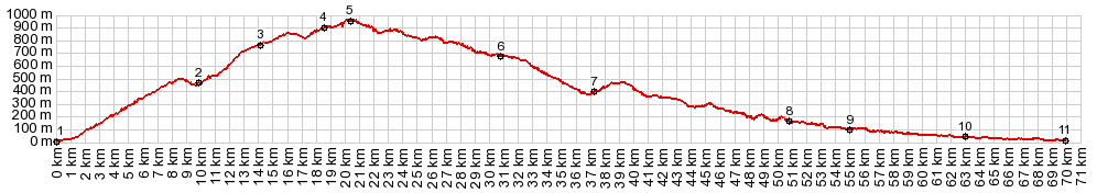
Venta la Nades s(u) , Alto de Isnate : Malaga Este > along the coast west > Rincon de Victoria > MA3203 north > Cajiz > Alto de Isnate > Isnate > Benamorcarra > MA3113 east > Triana > Benamargosa > Riogordo > A356 east > Colemnar > Venta La Nada s(u) > Puerto de Leon(shp) > back to starting point in Malaga Este: 72.3miles with 6490ft of climbing in 6:3hrs (garmin etrex30 r5:16.4.21)
|
|
|
advertisement |
|
|
advertisement |