| |
| |
Alto de Zambra
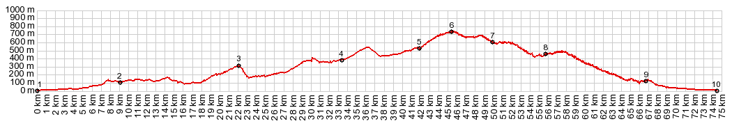
This road runs along the top of a ridge - with a million curves into Malaga. It's hard to believe that a road like this exists so close to a busy major city. Down in the valley on each side roads, traffic is channeled along limited access four lane highways, apparently with little or no service roads. This ridge route is represented on the right side of the profile below. The route from points 1 to 4 can also be used to ride from Malaga to El Torcal. From there its's a short ride to Casabermeja, and that is really where the Alto de Zambra route begins.
It follows my recorded gps track trough a few
steep streets in town. But it's possible to make
that a longer, more shallow climb. The idea is to
head for the small transmission towers on the
hill. The road passes a few derlict benches,
climbs the hill in serpentines, and crosses the
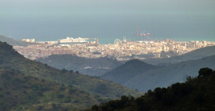
ridge to open a far view onto Malaga. During my
ride a strip of sunshine tears through the clouds
to light up the coast in a ghostly lit display.
The rest of the hills are shouded in black and
framed by green. I always imagined Norway to look
like this, not the Spanish coast. A dirt
road turnoff leads to the Torre de Zambra
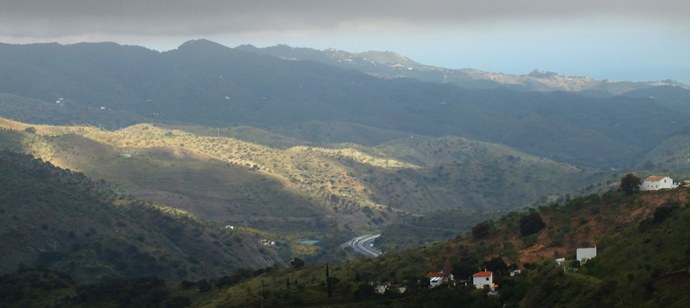
From East: (described
downwards) Along the curvy traverse on top
of the ridge I encounter about a handful of cars,
a handful of cyclists, and another handful of
chained dogs barking like crazy. On the right side
A46 strides over the bottom of the valley on a yet
another handful of graceful bridge stilts. In the
background the clouds condense into black
behemoths over the cliff known as El Torcal. If
there were such a thing as an electronic gadget
that calculates the total amount of curvature in a
road over distance, this would be the one road I
would love to try it out on. The curves really
never stop. 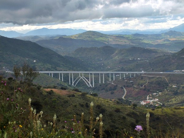 As the views of Malaga get ever closer, the tiendas become more frequent, a narrow bridge, a tunnel or two, and the road seems to dead end at the junction with a four lane highway. But - there is even a service road now, still with hardly any traffic. It lasts for the last few miles of the approach - finally landing straight as an airplane on a runway between the shopping streets of Malalga. In order to descend all the way to the harbor I have to finally put up with traffic lights, and a one way street system, that makes me loose my sense of direction. Which way to the water ? Only the the gps knows.
A ride with this point as
intermediate summit is on page: Venta la Nades
s(u)
|
|
|
advertisement |
|
|
advertisement |