| |
|
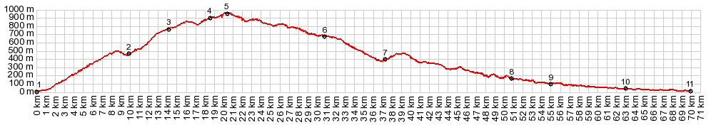
01.(00.0km,020m)START-END WEST: A7001 leaves from the coast
02.(10.0km,460m)shoulder summit point in Olas - jct with MA3110
03.(14.4km,760m)route turns off to the left, shortly before Puerto de la Bolina
04.(19.0km,900m)profile turns right onto A7000. Puerto de Leon is to the left
05.(20.5km,950m)TOP: point of highest elevation
06.(31.0km,680m)road passes through Colmenar
07.(37.4km,400m)Riogordo
08.(51.0km,179m)La Zubia
09.(55.0km,100m)Behamargosa
10.(63.2km,040m)route turns right onto A7205 in Trapicke
11.(70.0km,020m)START-END EAST: Velez Malaga
|