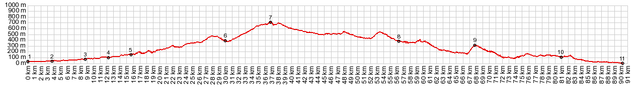
< Left Panel   Spain exc. Pyrenees   Areas   Tables   Maps   All Favorites  
Main Panel:   Main Page   Map+Profile   Iberia Map  


Colmenar(sh)

The hilltop town Colmenar is easily included as a shoulder point when cycling some of the other summit points in the Malaga area, especially when crossing the Venta la Nades. But, as the profile shows, you can also make this the highest point on a loop ride.

01.(00.0km,030m)START-END WEST: Velez Malaga
02.(03.6km,040m)profile turns onto sideroad MA3113 in Trapiche
03.(08.7km,070m)Trana
04.(12.3km,100m)Benamargosa
05.(15.4km,150m)going left here goest to Comares. Profile stays straight
06.(30.0km,390m)Riogordo
07.(36.8km,700m)TOP: highest point in Colmenar
08.(56.4km,380m)route turns left onto A7075
09.(68.1km,300m)jct with A3402 near Almogia
10.(81.0km,120m)El Chaparral
11.(90.3km,020m)START-END EAST: Malaga


Approaches

From East.
In order to show an approach, that does not go over a just slightly higher point before reaching Colmenar, the profile starts in Velez Malaga and follows narrow curvy country road. Along the way there is also an impressive easily missed view of the hilltown Comares from far below. I just happened to see it, because I was looking for picnic lunch stop and happened to pick a sheltered bus stop to get relief from the merciless April sun.

From Riogordo the map also shows a narrower road leading into the high side of Colmenar. The profile follows the more obvious newer main road. In Colmenar two high hills with narrow streets wait to be walked up. I suppose somebody might even ride up there, provided they make tires with that much traction.


From West. (described downwards). Again, there are really other scenic points to be climbed, between here and Malaga. But in order to get a strictly descending profile, the route crosses A45 and picks up the road to Almogia, which is also on my Puerto de El Torcal profile.


A ride with this point as shoulder point is on page: Venta La Nades s(u)


advertisement

advertisement