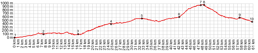
Puerto de El Torcal The Puerto de El Torcal is the
starting point to the short, steep and
spectacular road up to El Torcal. The latter is
an out-and-back road and much of it runs along
near the top of a broad bare ridge, with great
views in all directions. The Puerto de El Torcal
is also a fantastic ride on its own, connecting
two fascinating cities. The Andalucia Cycloturismo web
page loosely refers to this pass as "Puerto de
El Torcal", The name "Boca del Asno" also
appears on signs next to the road. This refers
to an ancient battle site between Christians and
Muslims.
Past Almogia the road reaches a low point and a
turnoff on a tiny road to the west would give more
elevation gain to Puerto de la Mujer. But A7075
climbs over rolling hills in open grassland to the
white village that has scenically underled the
view of El Torcal for dozens of miles, Villanueva
de la Concepcion. Starting here, a handful of steep switchbacks
climb ever closer to the base of the rocky lip
ahead. The grade of these switchbacks does not let
up in the turns. The inside of these turns are the
steepest part of the climb. Once close to the base
of the rock outcrop, a shallow straight away leads
to the highest point. There is no puerto sign but
the Boca del Asno is signed From North. (described downwards). The
interior plain on this side of the mountains lies
much higher, and coming from the US (as I do), the
first view of the landscape without the houses
reminds of Wyoming. Again there are a few
switchbacks, but they are finished before you can
get used to going downhill again. But then there
are the structures that get me back to reality,
the white farms, a few amazingly intricate ruins
that seem to be part of a sheep farm, and the many
tended fields and geometric fruit plantation
patterns. Two kilometers before reaching Antequerra, a left
onto MA4402
allows crossing back over onto the north side of
El Torcal. On a long dayride there may not be much
time to look around Antequerra. This city dates
back to the same time as Granada and Sevilla. But
it's location was much less strategic. So it's
less famous, but in my view at least as
interesting in a more sedate way. Sidetrip to El Torcal The summit road to the El Torcal visitor center
is really quite short. Many pictures on different
web sites are taken on these 4 kms. The road
traverses a karst topography. Some form columns,
and others are eroded into plates separated by
receding softer stones. To the south another ridge
sticks up into the landscape like an overturned
ship's bow. With a telephoto lens it looks very
impressive. The steep, flagstone lined climb
levels out on top and ends at a visitor's center.
There are several short trails, and an overlook
direction Mediterranean Sea here. 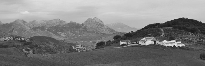 Dayride with this point as highest summit COMPLETELY PAVED: ( < Puerto
Santopilar | Venta La Nates
s(u) > ) Slideshow of the out and back
sidetrip to El Torcal: |
|
|
advertisement |
|
|
advertisement |