| |
| |
Comares s(u)
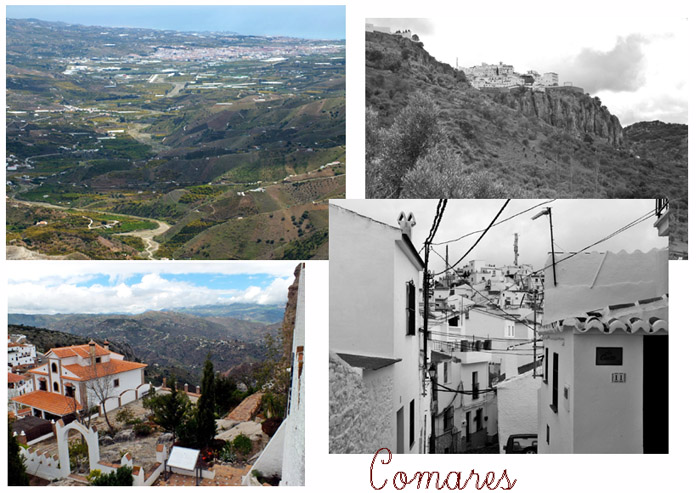
The hilltop town of Comares is the
biggest tourist attraction on a loop over four
summits, called the "Route of the Grape" in
tourist brochures. But that does not mean it's a
tourist trap, unless you consider a single bar/
restaurant and an old woman trying to sell her
homemade cheese, figs and a couple of tomatoes for
above average prices - a tourirst trap. Comares
itself and especially its cemetary has incredibly
views on a big breadloaf of a mountain, called El
Torcal, complete with surrounding ranges, passes
and sweeping valleys between them. This village
sits on a short loop that almost touches at the
starting point. It is located just north of the
summit of the unsigned Puerto de
Santopilar.
The gate at the entrance of town looks more like
a cardboard stage set than a medieval gate,
something you might find in Disneyland - well, not
quite that contrived. But it gets a lot better.
The road seems to end at a balcony like overlook
next to a bar. Steel benches invite for a picnic
under a fancy gazebo roof. Even if it's raining
this town has its advantages, and maybe by the
time the meal is finished, the weather will have
improved. It did in my case. The town can be explored in two directions, two
different high points, highlighted by the cemetery
and the church. The church is the higher of the
two, but as is usually the case, the cemetery is
the most scenic with the steepest cliffs, that
highlight the location of this town to perfection. The profile follows one of the narrow walkways or
streets to the summit at the church. Along the way
are several surprises, a small plaza with an
interesting statue, and then in my case a
woman selling food at above average prices to dumb
looking bikers like myself. Oh well, I hope the
few euros make her happy. I'm still in the novelty
phase of this ride.
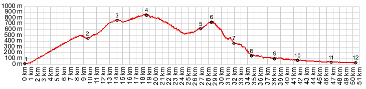
From South. (described downwards) But rather than following the paved road back down, I went looking for another way on one of the many double tracks on the north side. After several tries, I finally found the Ruta del Lavadero. This option, shown on the profile, rejoins Ma3111, about 200m below the paved road from Comares rejoins Ma3111 coming down from Puerto de Santopilar.
A Dayride with this point as intermediate
summit is on page: Puerto de
Santopilar
|
|
|
advertisement |
|
|
advertisement |