| |
| |
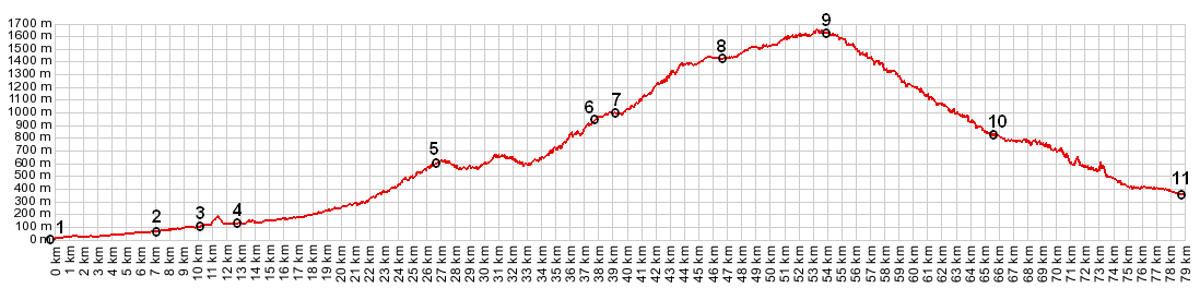
Col de Turini
This is the highest
paved pass, reachable in a conventional day loop
ride from the Nice/Menton area. There are many
ways to skin this cat, so many ways that you might
think you're in paradise. No real skin involved, I
mean of course the incredible variety of
approaches. Three roads meet at the top. But there
are three different ways to climb Col Ste Roch,
which is a shoulder point on one of the southern
approaches. This already brings the possibility of
loop rides close to the double digits. Below are
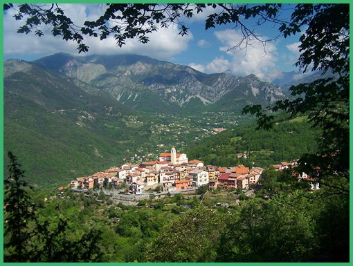
just a few notes on the approaches I tried out.
Scenically the most interesting part of this pass is the Gorge du Piaon on the South-2 approach. Every approach also has one extremely interesting medieval town to explore, Coraoze on the South-1 approach, Luceram on the South-2 approach and Bollene-Vesubie on the eastern approach. The summit itself would have no interest, if it were not the highest point along the route, or the starting point for a climb to l"Authion.
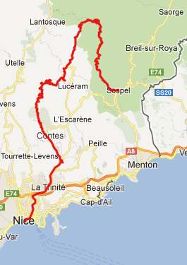
From South-1. The profile starts in Nice
and follows the busy road up through La Trinite,
the Condamine Housing Project to Drap, then D15
into Contes. On the map the road north of Contes
looks no differerent than to the south. But in
reality it couldn't be more different. The route
is a busy suburban highway to the outskirts of
Contes. Then all of a sudden the traffic seems to
just disappear as soon as the road starts
climbing, at least that was my pleasant experience
on a Friday in the middle of May. A carrot
dangling in front, also a reason to keep climbing,
remains in the center view for a long time, the
hill top town of Coraoze. It is easy to forget
about time wandering around the cemetery on top of
this town. You might call this a resting place
with a view - final or temporary. Past this rest stop, the road descends a bit, and
then really gets down to business, as the
serpentines, held in place with precision
brickwork, snake their way to the first pass. This
would be Col de Savel (980m). On top the viewshed
changes to the north. This would be the highest
point on a loop ride, combining this approach with
a descend on the right down a signed and numbered
dirt road to Luceram. The paved road past Col de Savel keeps on
climbing, traversing along a breadloaf shaped
ridge. The road visible below towards the west is
the approach from Luceram to the next named pass
on this route, Col
de Ste Roch. The approach described here
descends a bit before reaching Col de Ste Roch.
I stopped here and ate my picnic lunch, while my
bicycle posed for a photograph under the colorful
crucifix. What ? "only a crucifix, no restaurants
? no hotels and souvenir shop or bars for
the motorbikers ? Maybe you can tell from my
reaction that I was more only familiar with
conditions on mountain passes in the northern alps
at this point. The traffic too was amazingly
sparse. I don't remember seeing a car between the
far outskirts of Contes and here, although one or
three might have slipped my mind. But up here I
vividly remember a young kid on a motor scooter,
test riding the poor thing into the ground. I
think he wants to grow up to own a Lamborghini
instead of a Pinerallo. From my especially enjoyable lunch vantage point
I noticed a road far above. I thought that this
was probably the third approach to Col Ste Roch,
also going over Col de
Porte. But I turned out to be wrong. After
lunch I found myself climbing up there towards the
Col Turini. After the first switchbacks the first
views of the still snow covered peaks appear. Soon
the road levels out a bit and enters a magnificent
large needle forest, following the edge of a
gentle ridge, from which views of the peaks can be
caught between the trees. There is just one
settlement on this long last part of the approach,
Peira Cava. I managed to refill my water bottles
here, but it looks like they can provide food and
lodging, even as early as mid May. From here on a
road sign every km feeds the cyclist info on the
remaining climbing meters before the summit, the
remaining distance and the average climbing grade.
Something the signs don't tell you is that the
road reaches several slightly higher points just
before the pass. The nicest views along this
approach, in my opinion, are back before of Peira
Cava, with the high peaks of Mercantour Park in
the background. From South-2 (described downwards)
Turning hard right from the South-1 approach leads
to a road that is signed to Sospel. The first part
of the descend is a long roll through isolated
dense forest. l'Authion looms overhead, almost in
the sky. But down here it's quiet and peaceful and
no far panorama disturbs with excitement. A
picturesque church in Moulinet finally provides a
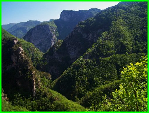
change in scenery. Then all of a sudden all scenic
hell breaks loose, as the road goes under an
unlikely bridge that seems to be there, just to
underline the picturesque location of a chapel on
the rock outcrop above. As you pass under the
bridge, the road enters the Gorge du Piaon. These
massive slabs of rock could be from any continent
with magnificent limestone canyons, but the walled
switchback road constructions and the impeccable
road surface could only be from the Maritime alps.
This short section through the Gorge du Piaon is
scenically by far the most memorable part of the
ride. Before entering Sospel, a right onto the
road over Col de
Braus provides an opportunity to get into
the right drainage basin again, if the starting
point was Nice.
From East.
(described upwards) The pass can also be
approached from the Nice area via the valley of
the Vesubie and D2565. The route leaves the gorge
north of Lantosque. The hill town of la
Bollene-Vesubie is another spectacularly perched
hilltown. Bollene has its own tourist office, so
there are opportunities to stay there. A small
chapel a little further up is another opportune
stopping point to admire the road construction.
Past this point the road uses switch backs to
climb the opposing hills side, providing a new
vantage point, from where the lower switchbacks
look like spaghetti salad. After the road enters
the forest and leaves the mountain rim, it is
still several hundred feet of relentless climbing
to the top. At the summit the road passes suddenly
and unexpectedly between two hotels and a bus stop
labeled "Col de Turini" to a junction with the
other two approaches.
Cycling: Surprisingly this pass was used
only three times, as part of the Tour de France
route, even more surprisingly all after WW2, when
Maritime Alp passes were used even less. The years
were 1948, 1950 and 1973. The stages were won by
two French and a Spanish cyclist. Dayride with this point as
highest summit:
Col de Turini , Col de Braus , Col de Nice(shp) , Col de Quatre Chemins: 177 bd observotoire, Nice > col de Quatre Chemins > la Trinite > Drap > Contes > Coraoze > col de Savel(shp) > col de Ste Roche(shp) > col de Torini > Moulinet > Sospel > Col de Braus > l'Escarene > col de Nice > Drap > col de Quatre Chemins <> out and back to more than 300ft below the summit > sp :78.1miles with 9110ft of climbing in 7:26 hours (VDO MC1.0 m4:12.5.11) The first pass with different start and end points on this Extended Tour is: Col de Vence A day on an extended Tour: (<D32 Utelle s(u)|Col de Castillon>) Col de Turini , Col de Castillon: Lantosque > Col de Turini > Sospel > Col de Castillon > Menton > Bordighera: 62.9miles with 5420ft of climbing in 6:23hurs (VOD MC1.0 m4:12.5.26). Notes: includes the riding part of a long room search on the coast back to Cycling Passes in Europe |
 Approaches
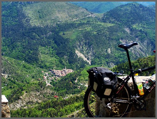
|
|
advertisement |
|
|
advertisement |