| |
| |
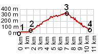
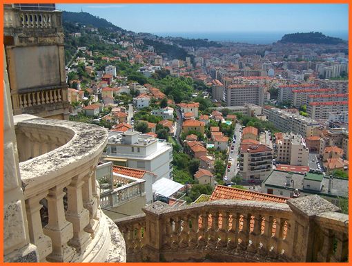
Col de Quatre Chemins
According to the
name of this low, but interesting pass, 4 roads
meet here. Actually it's at least 5. Three of them
meet in practically the same point. The third one
is about 20 meters south west of the other two
before mentioned routes, but it forks again within
about 20 meters. Instead of crossing the pass,
most cyclists just keep on climbing towards the Col d'Eze or one of
the many passes above it. Here are just a few
notes on the approaches to Col de Quatre Chemins.
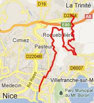
From South: This is the road with the most
traffic and also the most direct approach,
directly from Nice: the bd de Observatoire. It is
the easiest to find from the bottom, just follow
signs for Menton and Monaco over the Grand
Corniche. The lower climb is lined by vacation
condominiums and the occasional villa, also a 2
star hotel. Slowly the viewshed changes away from
the Nice rail yard to an expressway viaduct in la
Trinite. The road levels out a bit and passes
several entrances to the Vinagrier Park, a place
of peaceful repose, not far from the forest of
concrete walls and statues surrounding Nice. By
the time you reach the pass you are practically
surrounded by forest, bursting with bird calls.
Going back to the top, the previous
road forks within the first 20 meters below the
Col de Quatre Chemins. It looks like going
right here also leads down to la Trinite. The road
stays at altitude longer, taking in another
neighborhood under the expressway bridge.
However having taken this turn, invariably leads
to many different dead ends, still far above
Trinite (at least while staying on pavement). It
seems the people living here would rather
associate with the "on the hill crowd". From
North1: Proceeding further clockwise from
the Col de Quatre Chemins, the next road keeps on
climbing to the Col
d'Eze and further to the col de Guerre,
before descending to Menton.
From
North: the sign says it goes to
Villefranche and Beaulieu on the coast, haven't
ridden this. From South. The last
approach on the Chemin de Vinaigrier leads just a
few feet higher and could be considered a separate
summit. A bus stop is located on this route at the
intersection. The route descends through a sea of
concrete housing walls to the Corniche Moyenne.
The route is quite a bit steeper than the bd de la
Observotoire and also more densely occupied. - No
luxuriant jungle like vegeation and bird call
accompaniment on this route. At the intersection
with the Corniche Moyenne there is a "Restaurant
du Col", what - yet another Col ? Don't know if
this one has a name or not. Dayrides with this
point as intermediate summit are on pages Col de Torini, Col de Madone.
The first pass with different start and end points on this Extended Tour is: Col de Vence |
 Approaches, counterclockwise
starting with south:
Approaches, counterclockwise
starting with south: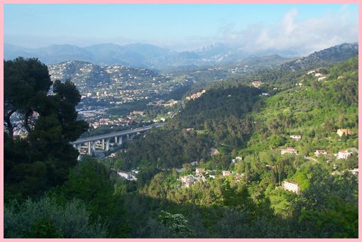
|
|
advertisement |
|
|
advertisement |