| |
| |
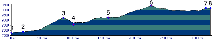
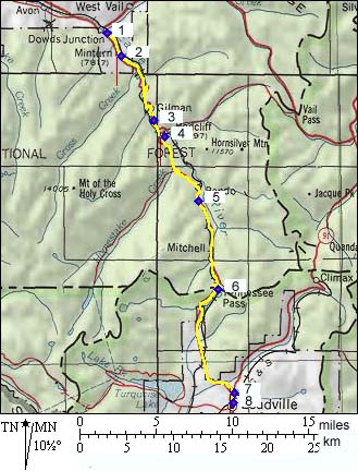
Tennessee Pass
Tennessee Pass is the third
highest summit on the Copper Triangle Loop, It
runs roughly parallel to Fremont Pass. Even though
Tennesee Pass is 900ft lower, it is a much more
pleasant and relaxing ride, far away from the
traffic of the city, surrounded by green hills
abruptly terminated in the distance by mountain
walls. Battle Hill
Summit the major part of the "big approach"
from Minturn, as well as an interesting summit in
its own right, vastly increasing the numbers of
possible loop rides in the area, but mostly with a
mountain bike.
From North. The largest part of the
elevation gain to Tennessee Pass is really
part of Battle Hill Summit. The most persistent
climbing workout is on that stretch. After
crossing the turnoff to Redcliff, the ride takes
on a forested valley character, propelling the
rider to 10400 feet through a variety of rolling
hills, and gentle forested inclines. This is one
of the most gentle ways to get to that altitude in
the state. Maybe for that reason, the pass is
often cycled in this direction. Peaks of the northern Sawatch Range make periodic
appearances behind a vast forest. From here they
almost seem to be at eyelevel. In the spring all
that ice at roughly the same elevation takes on an
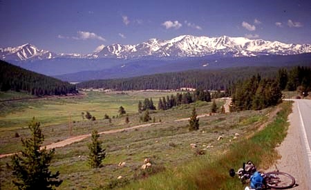
unlikely appearance. The road passes a little above Camp Hale, a
pleasant mountain park, made more scenic by the
Gore Range behind it. A grid work of abandoned
paved roads are left from the training facility of
the 10th Mountain Division. There are also many
interesting MTB climbs leaving from here,
including on the Colorado Trail. Leaving Camp Hale
signals the final ramp to the summit. The top of the pass in in open forest, with
surrounding mountains gently sloping far above.
There is a turnoff to Cooper Mtn ski area, another
dirt road leading a little higher on the west side
and a 10th Mountain Division military memorial -
and a single picnic bench, but not much in the way
of views.
From South. Looking at the profile, you might ask what approach ? The top of the pass is only 200 feet higher than the starting point, Leadville. Still, this part of the road has the best distant views onto the northern Sawatch Range. Dayrides with Tennesee Pass
as intermediate summit are on pages: A Day on Three Day Road Tour with this pass as intermediate summit is on page: Vail Pass History Fremont (<Currant
Creek Pass): The pass was well known by
trappers and traders of the 1830s. But the
official discovery of Teennesee Pass is credited
to professional hero Lieutenant Fremont and his
ragged group of "topographical engineers",
consisting of former trappers, traders and
mountain guides. The fact that the adjacent pass
to the south carries Fremont's name, and not this
pass, is an oddity. But then again maybe it is
quite fitting.
During Fremont's third expediton in August 1845,
he finally returned to the Colorado Rockies and
found Tenneesee Pass. However, now the manifest
destiny thing was really gathering stream. His
wife Jesse did her part too by embellishing
stories of what happened to Kit Carson, Tom
Fitzpatrick and their leader - her husband - in
the wild west. Brigham Young was amongst the
people studying Fremont's account of the west and
making plans to hit the trail with a sizable
contingent of followers. Meanwhile the mexican
government reacted furiousely to the american
annexation of Texas. Manifest destiny now called
for Fremont's military services further west. They
were about to be converted to military rifleman in
a mission to conquer California with the blessing
of president Polk. Ironically, Fremont now had
little time to develop enthusiasm or pay much
attention to further Colorado Pass explorations,
and he barely mentions his crossing of the pass in
his journal. It would later be named after the
home state of assorted prosepectors who frequented
the area. Fremont did return to passes in the Colorado
Rockies one more time, several years later, now
decomissioned but still working for his father in
law. Years before the official Gunnison
transcontinental railroad survey he was trying to
do essentially the same thing in the Cochetopa
Pass area. Hayden Survey (<Willow Creek
Pass|Battle
Hill Summit>): Tennessee Pass was crossed
by the Hayden Survey in their first summer of
surveying in 1873. One reason was to confirm the
existence of Mount of the Holy Cross on its west
side. They continued the summer with mapping a
part of the Flattops lakes. 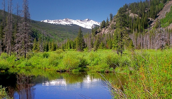 Leadville Boom (<Hagerman Pass|Chalk Creek Pass>):
Tennessee Pass today is a major route between the
I70 corridor and Leadville. However the pass came
into usage when Leadville was the economic center
of the state in the early 1880s, and the area
south of the pass was frontier country. The pass
served as connection to Leadville. There was no
road over what is now Vail
Pass to the rest of the world. Overflow
miners looking for greener mining pastures crossed
Tennessee pass from Leadville and founded
Redcliff, Gold Park, Holy Cross City and other
early developments. Railroads (<Fremont
Pass|Poncha
Pass>): When the DRG (Denver Rio Grande
railroad) had finished its tracks into Leadville
in July 1880, it did not rest on its profits.
Rather it began work on servicing mining camps
around Leadville. Tracks over Fremont Pass had
serviced Kokomo and Robinson. Tracks over
Tennessee Pass serviced Redcliff on the Eagle
River. In 1890, the DRG, now under new management, decided to relocate its main line between Denver and Salt Lake City. Before narrow gauge engine chugged their way down to Pueblo, up the Arkansas to Salida, over Marshall Pass to Gunnison, onward to Grand Junction and Utah. Now they still would travel to the Arkansas valley by the same ludicrous, bow shaped southern detour. But from Leadville they crossed Tennessee Pass and then continued towards Glenwood Canyon to Grand Junction. On that occasion, the line over the pass was also converted to regular gauge and the tunnels were constructed. Tennessee Pass deserves a special place in
railroad history. It was the highest railroad pass
in the US, and it was the last Colorado railroad
pass to be shut down. During the last decade the
DRG became part of the Southern Pacific, finally
swallowed by the historical foe of them all, the
Union Pacific. That railroad finally abandoned the
line. The line would make a great dedicated
bicycle trail, made even greater by its connection
to the Vail Pass
trail. 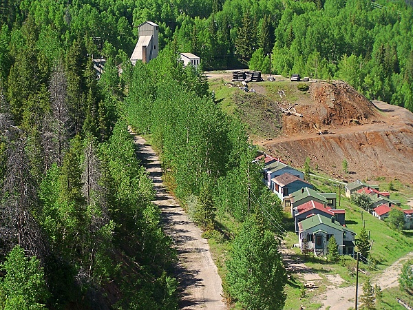 Modern Highways (<Trout Creek Pass|Berthoud Pass): In
1913 Tennessee Pass became part of the
second designated cross country automobile route.
In the east travelers had an atlas of roads to
choose from. In the west choices were more
limited. The "National Old Trails Road" reached
Colorado Springs over Raton
Pass then continued over Ute Pass, Wilkerson Pass, Trout Creek Pass,
Tennesee Pass onwards to Grand Junction,
Utah and Los Angeles. Cycling - Ride the Rockies: (<Wind River Pass|Hesperus Pass>): The Denver Posts "Ride the Rockies" crossed Tennessee Pass four times between 86 and 05, which is not that often for a pass so close to Denver. The reason for this is that a route over Tennessee often makes a route over Vail inevitable in order to connect to Denver. Vail Pass however is less than perfectly suited for 5000 bicycle wheels at one time. A route over Tennesee avoiding Vail was followed in 88 93 98 and 01. The day's stage was Vail to Frisco, Avon to Frisco and Buena Vista to Avon. 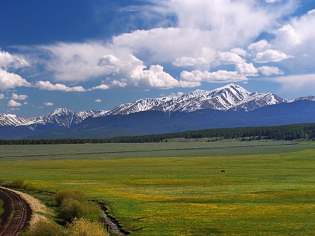 |
 Approaches
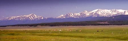
 Fremont had a deep desire to
explore high Colorado passes ever since he got the
job mapping the west for possible emigration and
military routes from his father in law. That just
happened to be Senator Hart Benton, originator of
the catchphrase "Manifest Destiny". America was
destined to become a continental power stretching
from sea to shining sea, which would also include
California, Oregon and Mexiico, all of which where
still officially spanish. Fremont's previous two
expeditions had centered around Wyoming and its
emigration highway west, the Oregon Trail. Only on
his way back home during his second expedition had
he penetrated the Rockies over Hoosier Pass and
Currant Creek Pass.
Fremont had a deep desire to
explore high Colorado passes ever since he got the
job mapping the west for possible emigration and
military routes from his father in law. That just
happened to be Senator Hart Benton, originator of
the catchphrase "Manifest Destiny". America was
destined to become a continental power stretching
from sea to shining sea, which would also include
California, Oregon and Mexiico, all of which where
still officially spanish. Fremont's previous two
expeditions had centered around Wyoming and its
emigration highway west, the Oregon Trail. Only on
his way back home during his second expedition had
he penetrated the Rockies over Hoosier Pass and
Currant Creek Pass.|
|
advertisement |
|
|
advertisement |