| |
| |
Willow Creek Pass
 This is a fascinating high
valley, that stands in contrast to the adjacent
valley to the east. Over there it's the
commercialism and real estate frenzy that comes
with being adjacent to a national park. Over
here along WIllow Creek, the really high peaks
are out of sight and out of mind. The (for
american standards) narrow road has no shoulder
and it does not need one. It follows the
meanders of a high and free (undammed) litte
stream through a peaceful collection of rounded
hills, that sun and clouds turn into a muddled
carpet of greens. This is a fascinating high
valley, that stands in contrast to the adjacent
valley to the east. Over there it's the
commercialism and real estate frenzy that comes
with being adjacent to a national park. Over
here along WIllow Creek, the really high peaks
are out of sight and out of mind. The (for
american standards) narrow road has no shoulder
and it does not need one. It follows the
meanders of a high and free (undammed) litte
stream through a peaceful collection of rounded
hills, that sun and clouds turn into a muddled
carpet of greens.
From South. After cruising along on US40
along an initial version of the Colorado River,
the first wake up climb on Co125 can be rough, if
it is very hot. But this climb leads up into an
area that tends to be cooler than most parts of
the state, and then becomes a lot gentler. The road on this side can have a mildly
hypnotizing effect if you let the meanders of
Willow Creek do their job. The small creek is
lined with wetlands. The eye meanders between
grasslands, bushes and wildflowers. Since the
forest fires, most of the old campgrounds are
closed, and many of the dirt road turnoffs are
closed to motor vehicles. Amongst the gravel
climbing turnoffs on this side are Kaufman Creek
Rd, Stillwater
Pass and others. Approaching the top the
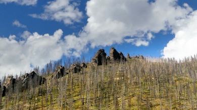
road comes close to Park View Mtn (12296ft). An
appropriate trailhead is a mile or two below below
the summit. The pass summit itself does not really have a
view of the landscape. Instead a large pass sign
points our the sides of the Continental Divide,
east and west. Thank you. It towers high on an
embankment above the road cut. The sign seems to
appear in many tourist photos.
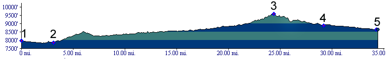
Three Day Road Tour. A supported camping
tour, done by the Denver Bicycle Touring Club in
past decades, went like this: Day 1: Steamboat
Springs to a campsite on top of Gore Pass, 50
miles measured distance. Day 2: Gore Pass to
a campsite near Granby, 52 miles. Day 3: Granby
over Willow Creek Pass, a shoulder of Muddy Pass
leading to Rabbit Ears Pass back to Steamboat
Springs, 90 miles. All mileages were measured with
a now antique, Schwinn approved, pinwheel driven
odometer, guaranteed to be accurate to within
aproximately 15 percent, when not going too fast
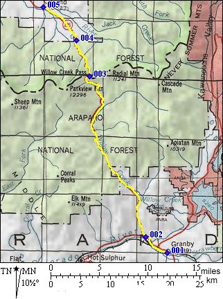
for a misfunction to occur (r1:83.09.05). Dayrides with this point as intermediate summit are on pages: Stillwater Pass ,
Illinois
Pass , Kaufman Creek
Rd s(u) History Hayden Survey (<Muddy Pass|Tennessee Pass>)
This low pass was one of three between Middle and
South park inspected by a subgroup of the Hayden
Survey, in their first year of
mapping. From here the group joined
with main group to travel over Tennessee Pass.
|
|||||||||||||||||||||||||||||||||||||||||||||||
 Approaches
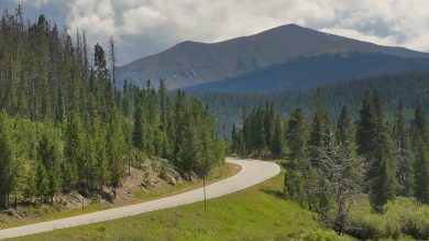 From North. (described
downwards). The one chance for a view of high
mountain peaks above treeline comes a short
distance past the summit. This is one way to
experience the Rocky Mountain Park area without
crowds, albeit you need a telephoto lens. Not
having a sinuous stream to follow on this side
makes the road much straighter as it cuts through
the wild green forest. A perfect stretch to
meditate and find peace around yourself as within.
Rand is an interesting collection of summer huts.
From North. (described
downwards). The one chance for a view of high
mountain peaks above treeline comes a short
distance past the summit. This is one way to
experience the Rocky Mountain Park area without
crowds, albeit you need a telephoto lens. Not
having a sinuous stream to follow on this side
makes the road much straighter as it cuts through
the wild green forest. A perfect stretch to
meditate and find peace around yourself as within.
Rand is an interesting collection of summer huts.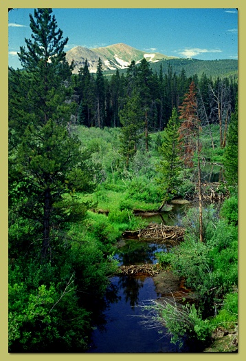 A Day on a Tour with this point
as highest summit:
A Day on a Tour with this point
as highest summit:|
|
advertisement |
|
|
advertisement |