| |
| |
Fremont Pass
Fremont Pass is the highest
point on a popular loop ride, called the Copper
Triangle. In spite of this, it is not a ridge
line crossing, but meeting point of two high
alpine valleys near treeline. It connects the
I70 traffic corridor to Leadville and the upper
Arkansas Valley. The road passes between the
northern Gore Range and the Tenmile Range. The
flanks of the Tenmile Range faces to the east
are more precipitous, while the northern end of
the Gore Range terminates in a series of rounded
hills west of the pass. The dominant scenic
feature along the route is not the Tenmile
Range, but rather the lack of part of it. The
Amax Molybdenum mine operation at the pass have
cut away a good portion of two peaks. The series
of settling ponds, where the erosion process has
been speeded considerably over what nature would
have done, can be seen all along the route.
From South. The lowest point of the approach is several miles out of Leadville, still past the turnoff to Tennesee Pass. However, Leadville makes a convenient starting or stopover point on a biycle ride. The road to the highest part of the Arkansas Valley could be mistaken for just another little breadloaf hill on first sight, as you make your way up towards the molybdenum mine. But the last long meander up to the pass is longer and higher than it first appears from the bottom. From North. (also described
upwards). Unfortunately the bike path spur,
connecting with the Vail Pass path, only lasts a
very short distance up Fremont Pass. After that
the rider is alone with the traffic, albeit on a
nice shoulder without rumble strips. The northern
approach begins as a fairly steep, straight climb.
Two lanes of traffic soon spread out to a climbing
lane for cars and a wide shoulder, though it may
be quite sandy for skinny tires. The last unspoiled view up the jagged ridge line,
making up the Tenmile Range, is from Mayfower
Gulch (picture below). After the settlling ponds
from the mine take over the scenery (last
picture). Behind them loom the frosty molars of
the Gore Range. The approximately 5 mile long
series of rolling hills along the top technically
belong to the northern approach. The entrance to
the mountain top removal facility (or mine) is at
the very top of the pass. Before that a mighty
dirt boulevard tunnels under our road. This is
actually a "mine freeway" without access for the
general public. A few old mining carts are
displayed in a small park at the summit. But this
is little consolation for the mountain range
turned to rubble. Hi The human story of this pass starts with a matter
of enormous, theoretical importance, and hardly
any practical importance. In 1803 the pass was
used to define the western boundary of the
Louisiana Purchase. The area west of the pass was
still theoretically Spanish, which did not matter
much to trappers and traders crossing this or any
other of the many passes in the area. Then came the military. One of the most famous
examples of this second era of pass exploration is
Col. Fremont, as can be seen by the number of
objects that his name is attached to - towns,
peaks, parks, and passes, like this one. Col Fremont. was part of the Corps of
Topographical Engineers, a part of the US Army.
But as politics would have it, the corps was soon
commanded by Senator Thomas Hart Benton. The fact
that Fremont was Benton's son in law was Fremont's
most obvious credential for getting the job.
The idea that nepotism is not an acceptable way to
fill open federal positions is a concept that
seems to have developed much later. Fremont went
on to become a professional explorer and hero
anyway.
Leadville Boom (<Loveland Pass|Currant Creek
Pass>) Fremont Pass came into heavy use
during the time of the Leadville mining boom.
During the summer and fall of 1878, every route to
Leadville was jammed with wagons, stages, buggies
and carts. Most of the Leadville traffic traveled
from the Front Range communities to South Park
over one of the Mosquito Range passes. A route
from Denver over Fremont Pass became feasible
after a continental divide crossing was achieved
over Loveland Pass.
At that time the Fremont Pass Trail became a rough
road, and soon an integral part of the main "buggy
arteries" between the Front Range communities and
Leadville. The pass continued to play an important role as
the boom matured in the early 1880s, but a quite
different role. Overflow miners from the Leadville
area now started the settlements of Kokomo and
Robinson on Robinson Creek. Railroads : Fremont Pass was crossed by two separate railroads from opposing directions, all in the name of competition. Therefor this thread traverses this pass twice. (<Trout Creek
Pass|Tennessee
Pass>) After Palmer's Denver Rio Grande
Railroad (DRG) had monopolized rail traffic to
Leadville, Fremont Pass saw rails being pushed
over its top from Leadville to serve the mining
outposts near the top of the pass, also part of
the DRG empire. (<Boreas Pass|Loveland Pass>)Years
later the Union Pacific (UP) had taken over the
Denver South Park (DSP) and made another
attempt to invade the DRG Leadville monopoly. The
DSP reached Leadville from an entirely different
route. Rather than the long southern bow through
Canyon City and the Arkansas Valley, the DSP
needed to cross two passes from its long standing
roundhouse in Como, South Park. Fremont Pass was
the final link in the DSP's route between Denver
and Leadville. The Denver Leadville distance on
that roller coaster crossing the continental
divide twice was 150 miles. Compare that to 280
miles on the flatter DRG route and the plan begins
to make sence. Not surprisingly DRG laywers
delayed DSP progress for two years so that DSP
trains did not cross the pass untill Sept 30/1884. During the time when both rail lines were in
operation, an observer could stand near the top of
the pass and see an incongruous sight, trains
"leaving" the Leadville area in opposite
directions. A DRG might be taking ore from Kokomo
to Leadville onwards to Canyon City and Denver. At
the same time a DSP train might be crossing the
top to carry Leadville ore onwards to Boreas Pass, South
Park, Kenosha Pass
and Denver. The DRG eventually won this cometition
and even changed its operation over from narrow
gauge to regular gauge in 1937. The pass is still
reached by a railroad, but not crossed. The
railroad exists just for Sunday tourists. The
Leadville, Colorado and Southern started an
excursion service in 1988. The name Fremont Pass is also due to the
railroad, in spite of what mister Fremont would
have thought. Miners called it Arkansas Pass as
late as 1872, federal agencies labeled it Tenmile
Pass. But the railroad said it was Fremont Pass,
and Fremont Pass it still is. In the 1870s Fremont Pass was a way for people to
come to the mines. More recently a really large
mine has come, if not to the people, to the pass.
A substantial chunk of the Tenmile Range has been
cut away by the molybdenum mine on its summit. The
history of a ore on top of the pass dates back to
the mining boom days, when the molybdenum ore was
mistaken for graphite. This mistaken assay
analysis was only corrected after WW1, and only
then did it have practical consequences. The picture above is take on the slope above the
pass, not the pass road itsself, while the picture
below shows the scene above a settleing pond. The
scenery along the top is dominated by tailing
ponds, not alpine lakes. It's spectacular
nonetheless, in an industrial sort of way. 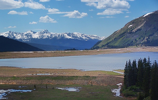 Cycling - Ride the Rockies: (Loveland Pass>):
One group that prefers Fremont Pass over Vail Pass is the Denver
Post and its "Ride the Rockies". The reason is
clear. Getting a thousand additonal riders over
the Vail Pass bikepath would be like getting a pot
of mashed potatoes through a needle's ear. Fremont
Pass is the Ride the Rockies' most frequently
crossed pass, while Vail Pass has never been used.
The massively large group crossed Fremont Pass a
full 10 times between 1986 and 2005: ( 86 88 89 91
93 94 97 98 2000 and 2003 ). The days stages were
always Leadville to Frisco or Vail to Frisco,
except 2003 when it was Buena Vista to
Breckenridge. The link under this heading follows
other "Ride the Rockies" passes in descending
order of number of times that they were crossed.
|
||||||||||||||||||||||||||||||||||||||||||||||
 Approaches
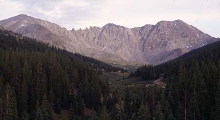 story
story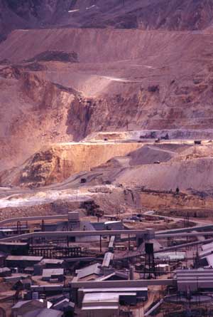 That's a
couple of sentences about Col. Fremont. The only
thing left to mention with regard to this pass is,
that he did not cross it. He crossed the pass
north of here,
That's a
couple of sentences about Col. Fremont. The only
thing left to mention with regard to this pass is,
that he did not cross it. He crossed the pass
north of here, |
|
advertisement |
|
|
advertisement |