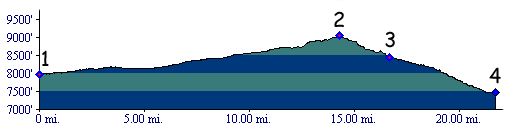
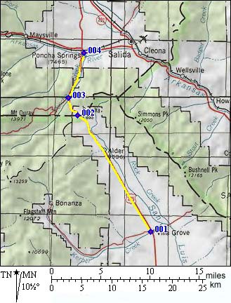
| |
| |
Poncha Pass
Poncha Pass is the main entrance
into the San Luis Valley from the north. It is for
today's US285, and - once upon a time - it was for
de Anza chasing Comanches, as well as the Denver
Rio Grande Railway. This is a passage between two
magnificent, wide valleys, dividing the lower
slopes of the Sawatch Range from those of the
Sangre de Cristo Mouuntains.
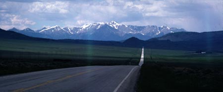
The road itself is stuck in a low ravine. It is the entrance into San Luis Valley on a north to south ride, and it is that entrance, that leaves an impression. The road descends into the valley, like an arrow aiming straight between large, gentle, fan shaped landforms, leading up to a linear mountain range. The Sangre de Cristo Mountains have some unique characteristics for a Colorado mountain range. These peaks not only contain groups of rugged, glaciated peaks but also alluvial fans, characteristic of dessert ranges further south. These large fan shaped landforms at the mouth of canyons are water deposited sand and rocks, which accumulate in a gentle slope, instead of being washed out of the valley, as would be the case in a wetter climate.
From South. When approaching the pass from the San Luis Valley, the thought of a curving pass road seems very remote. There are no road bends to be found anywhere (see picture below). The far mountain range in the first picture is the Sawatch Range on the other side of the pass. These peaks are completely hidden from view, once higher up on the pass. There are a few curves near the top, but nothing resembling a switchback, and nothing that approaches a serious climbing workout. From North. This is the higher of the two
approaches. The road curves gently between sage
covered hills. The high peaks of the Sangre de
Cristos do not come into view until descending the
other side.. The shoulder is wide enough to get away from any
and all traffic.
 History de Anza(Ute Pass>): Poncha
Pass storms into the pages of frontier history
when de Anza pursued Comanche Indian in 1779. But
just like him, the story too is going to take a
while to get there. Juan Bautista de Anza, governor of Spanish New
Mexico, had already proved himself as frontiersman
and trailblazer. In 1774 he established a trail
between Central Mexico and the isolated outposts
of the Spanish empire in California. That trail
passed through Mexico, Central Arizona and over
San Carlos Pass in California. In 1777, one year after the rambling Escalante
expedition had meandered through the four corners
area, Charles the 3rd of Spain appointed de
Anza governor of New Mexico. A particular task of
his was to subdue the Comanches, who had taken
over much of the old Apache country. While
Comanches were described as terrorists by the
Spanish, relations with the sedentary Ute Indians
were much better. They served as guides to the
Spanish. In August of 1779, several hundreds of Comanches
were reported to assemble in San Luis Valley -
that's how it finally began - the discovery of the
northern most passes of the Spanish empire on this
continent. Previous Indian raids had ended with
the Spaniards chasing north over Raton Pass and freying
out into the upper Arkansas on the plains. De Anza
fought the Comanches by heading north into San
Luis Valley crossing the current New Mexico
Colorado border. As he pursued the Comanches north, de Anza made
his first big geographical discovery. The river he
followed, the Rio Grande, did not originate
thousands of miles to the north, and definitely
not at the north pole as was suspected. It veered
to the west into the high San Juan Mountains. But
his long Comanche chase route kept him closer to
the valley floors. In today's geographical terms
it could be described like this : After the Rio
Grande settlements of Monte Vista and Del Norte
the route heads north across La Garita Creek,
through the Cochetopa hills. Here the confusing
topography provides many challenges to reconstruct
the route, as any bicyclist who ever tried to
cross the nearby Moon Pass can testify. The ususal
everpresent landmarks of the Sangre de Cristos on
one side and the San Juans on the other are not
visible from the maze of ravines cut in these
hills. Heading north along the chase route, the
Cochetopa Hills are bisected by a large sagey
valley. Through it flows Saguage Creek, and it
lead the chase back into the San Luis Valley. From here the route becomes easier to follow on a
bicycle. Head north on towards the only obvious
gap in the mountains, straight up the northern end
of the San Luis Valley over Poncha Pass. Now we're
back at the beginning of the story. De Anza
finally crossed Poncha Pass. Up to this point the
chase route had stayed in sage country. Poncha
Pass too, is a far cry from alpine. But now the
Comanches headed for real mountains, up across the
northern edge of the Mosquito Range over Cameron
Mountain, towards a flank of Pike's Peak, the area
surrounding the little town of Guffey. The chase
continued over a variant of Ute Pass. In all probability the name "Poncha", meaning
mild or gap, is also due to de Anza. Many
years later, in 1874 a member of the Hayden
Survey, Franklin Rhoda, used the name "Puncho",
which doesn't mean anything except perhaps that
Rhoda did not speak spanish. Another remote
possiblity is that Poncha is derived from
"Poncoa", the name of an Indian tribe. Otto Mears Passes (Marshall Pass>):
Otto Mear's story is the prototypical American
immigrant capitalist success story. A jewish
orphan, born in the Ural steppe of Russia,
orphaned at the age of two, he arrived in San
Francisico to be received by an uncle who never
materialized. Working his way up from news paper
delivery boy, he found himself a merchant and
indian trader in the town of Saguache in the
1860s. Building a toll road over Poncha Pass was a
natural extension of Otto's first line of
business, which was supplying miners in Oro City
from his store in Saguache. Poncha Pass was Otto's
first toll road. It was the first of many to come.
With the help of John Laurence it was officially
chartered in 1870. This was not the first attempt
to operate a toll road on the pass. Official
charters from 1861 and 1865 did not result in
successful operations. But it was the start of
Otto Mear's pass empire.
Gunnison Rail Survey (<Medano Pass|Marshall Pass>):
Poncha Pass was explored for use by a possible
first transcontinental railroad by the Gunnison
expedition in 1853. The group examined the pass
from San Luis Valley. The verdict was favorable:
"the best watered, grassy valley, with wood
convenient for fuel that we have seen on this
section". They proceeded to name the present area
of Villa Grove after their field astronomer Homan.
The name Homan Park is still on today's maps. The
expediton crossed the pass from San Luis Valley
into the Arkansas valley, describing Marshall Pass along
the way. In the Arkansas Valley, they noted
several indian paths to the Wet Mountains and the
Hardscrabble area, then returned back over Poncha
pass to San Luis Valley. Captain Gunnison would
later be tragically killed by Indians in Utah
while still on this expedition. But an attempted
name change to honour the fallen Gunnison by
naming Poncha Pass after him did not stick. Railroads (<Tennessee
Pass|Marshall
Pass>): The Denver Rio Grande
Railway crossed Poncha Pass from the Arkansas
valley in 1881 to do business with mines in the
upper San Luis Valley. But the railroad's real
objective was Marshall
Pass, and the ore traffic from Gunnison.
Lucky for the railroad, the inital approach from
Salida also served the line over Marshall Pass. In
1890, the DRG narrow gauge tracks in the San Luis
Valley were even extended from Villa Grove to
Alamosa to carry yet more silver ore, arriving in
wagons from Creede. But rails in the San Luis
Valley was a short lived phenomenon. Nothing
remains today, except perhaps a name given to the
sleepy town town of Moffat, who was a different
boss of a different railroad altogether. Unlike
the DRG main line through the Arkansas valley, the
Marshall Pass route remained narrow gauge until
operations ended in 1952. The rail were salvaged
three years later. ( An earlier version of this page said that the
line over Poncha Pass was converted to regular
gauge, as stated in Marshall Sprague's "the Great
Gates". I was corrected by a reader, that this
never happened.) Modern Highways (<Trail Ridge
Road Passes|Marshall
Pass>): In 1914 the road was finished
with a hard gravel surface to suit the coming
automobile boom. Between the two world wars Poncho
Pass became part of a touristic route called "the
Tenderfoot Trail", between Salida and the San Luis
Valley. Cycling - Ride the Rockies (<Monarch Pass|Co131 summit(u) State Bridge - Wolcott>): As of 2005 the pass has been crossed by mega crowds of "Ride the Rockies" during 91 94 96 00 and 02. The day's ride always covered Alamosa to Salida, except once when it was Salida to Alamosa. 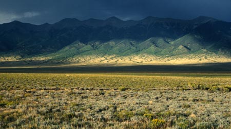 Dayrides with Poncha Pass as intemediate summit are on pages: FR869 Toll Road Gulch s(u)Hayden Pass
|
||||||||||||||||||||||||||||||||||||||||||
 Approaches
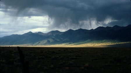
|
|
advertisement |
|
|
advertisement |