| |
| |
Hagerman Pass
The Sawatch Range below Hagerman
Pass just happened to be the strategically correct
area, to be tunneled a total of three separate
times. The first two tunnels started out as
railroad tunnels and the third is a water tunnel.
Today the pass road has two separate characters,
that come from this history. The lower part is the
railroad grade to the tunnel, a gentle, wide,
carefully engineered roadbed, one that has to
support not only a narrow gauge railroad, like the
DSP and its Alpine Tunnel approach south of here,
but a heavier standard gauge railway. Above that
the pass becomes more rugged and the origin of the
road is a construction road, that was needed for
all the various tunneling projects.
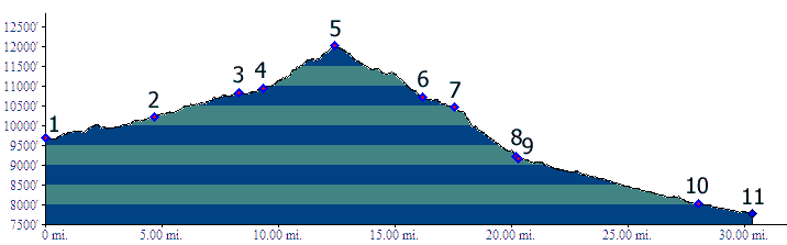
Modern sources and topo maps list the altitude of the pass at 11925ft. However, the road reaches a slightly higher point just south east of the pass. Marshall Sprague's "the Great Gates" lists the altitude at 12050ft, which is just a little too high.
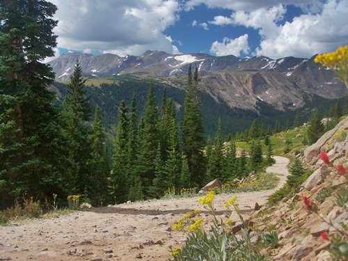
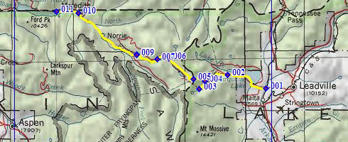 Approaches From East. The paved road around Turquoise Lake reaches already a height above the lake, that could easily afford scenic overlooks. But it's stuck in the trees. At an intermediate high point on the south western side of the lake, unpaved FR105 takes off to traverse up into the mountains. The first mile or so can be a bit of a washboard surface. But during an out and back ride, this will only be noticeable during the first leg, because there are much rougher sections waiting further up. In any case, the washboard ends soon, as a smooth wide all weather dirt road follows the railroad grade far above Bush Creek. The lower and newer of the two tunnels (at various times named Ivanhoe or Carlton) is at the first switchback. All that can be seen here today is a black barricade, blocking a hole into the mountain. In this area are also a number of trailheads that lead into the wilderness area. A sign warns against further uphill travel in a regular car, but actually the road stays smooth till the next waypoint, and even if it wouldn't, mountain bikers don't have to worry about this. The next waypoint is easily missed. It is the junction, where the railroad grade to the higher and older of the two railroad tunnels diverts from the pass road (for more details see "sidetrip to Hagerman Tunnel" below). The pass road itself becomes extremely rough for a while after this point, but compensates at the next switchback with a prime overview on Turquoise Lake. The high peaks in the Sawatch Range along the continental divide to the south are also in their best light during a morning ascent. After a few curves in the forest, the road heads
straight west for a wide saddle, together with the
main powerline to Grand Junction.
From West. (also described upwards) The western side of this pass makes a greener, more isolated impression. Fewer travelers from below find their way up the already long, circuitous route to Ruedi Reservoir. And that's just where the profile starts. The road remains paved for many miles past this to its junction with FR204, the Frying Pan Lakes Trailhead road. The last part of the paved section is already a interesting railroad shelf route. A reasonably good dirt road keeps climbing steadily, but without letting up, through the forest. Checking this section on the profile, it seems very steep for a railroad grade. The route emerges onto a small scenic park that also makes a good turnaround point on an out and back ride from the east. When I got there in the afternoon, the surrounding peaks were bathed in dark blue light, sunlight reflecting off the afternoon storm clouds. A look at the map also reveals that I had just passed something called Hell Gate, a scenic spot where the train used to stop to let visitors marvel at the scenery. Maybe that was the deep rock cut back there, but actually the views from this park at the junction with FR532 are much nicer in my opinion. Past this point the road gradually becomes rougher, until this ascent (just like the other ascent) takes off its railroad grade hat and puts on its construction road hat. This happens at the junction with the Ivanhoe Lake Road. The two railroad tunnels have their western portal at a level, at and above the western end of Ivanhoe Lake. The pass road on this side is still very
rideable. It follows the powerlines, which give
off a humming noise in the rain (yes it was
raining during my last ride) so loud, it would
probably drown out the railroad noise, if it were
still here. Approaching the treeline, the road and
powerlines are further appart. Sidetrip to Hagermann Tunnel Portal, east side: You can also follow the old railbed, or a trail approximating this route to the eastern entrance of the Hagerman Tunnel. The sign, where the trail leaves the Hagerman Pass Road is easily missed, even on a bicycle, but not the parking lot across from it. Located a short distance past the entrance to the Busk Ivanhoe tunnel (at the first switchback) a wooden sign, recessed into the woods, says a few kind things about the Midland railroad. A short single track trail leads to the railbed, and then follows the easily rideable track south as far as the site of a trestle bridgeFrom here the signed trail leaves the railbed, and in short distance reaches the old labor camp town of Douglass ( the double s is not a misspelling ). Writers try to outdo one another in cutesifying descriptions of the Old Wild West in Douglass. A trail sign in front of the remnants of a wooden shack says "This one street city had eight saloons, mostly in tents plus a dance hall. Here the professor played the piano while the ladies of the evening, too jaded for Leadville entertained and took the laborers money The wild city was well known for dinking, shooting, fighting, knfing and other innocent pleasures". Marshall Spraque in "the Great Gates" writes: "They built a fine tunnel, but their best efforts were devoted to cultivating the alpine night life of their shanty town amongst the Ptarmigans, Douglass City. This delightful place had no police, no firemen, no churches, no schools, and no chamber of commerce. During its brief existence, it won fame as the drunkenest, gamblingest, most lecherous spot in the Rockies, winding up in a blaze of alcoholic glory when the tunnel's powder house blew up. - You get the picture. 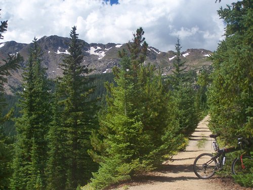 Following the signed trail, the final steps from Douglass to the portal are not rideable. This portal is not nailed shut. On August 25th /2011, the entrance still contained several feet of snow. Just below the tunnel entrance is a beautiful lake, that is a mixture of wild scenic beauty and unidentifiable, strange industrial mystery junk left from a different period in history. Wild lodgepole pines share attention with rusting metal braces hanging on an industrial pole, and if you try to get to the lake surface, reflecting dark afternoon storm clouds, you step over industrial foundations. Travelling in a train of the early 1890s you would only catch a brief glimpse of this scene, right before or after you were swallowed by darkness of the tunnel. A ride to this point is included under the CR9 Turquoise Lake s(u) page page. Dayrides PARTIALLY PAVED / UNPAVED: Hagerman Pass x2: Above Turquoise Lake area <> FR105 <> Hageman Pass <> turnaround point Meredith: 76 miles (mechanical odometer m1:87.08.29). UNPAVED: Hagerman Pass x2: jct: Turquoise Lake Rd -
FR105 <> FR105 <> Hagerman Pass
<> turnaround point at beginning of pavement
at jct FR105-FR204 Fryingpan Lakes Th road:
42.3miles with 4310ft of climbing in 5:18hours
(VDO MC1.0 m3:11.8.24) History Leadville Boom(<Mosquito Pass|Tennessee Pass>): In the early 1880s the Leadville Mining boom was in full swing. Dozens of little towns dotted the upper Arkansas Valley, named after places left behind in Iowa, Illinois, Ohio or Maine. Conditions were already getting crowded. In the search for yet other rocks containing mineral wealth, miners crossed Hagerman Pass, then called Frying Pan Pass, down to the Frying Pan River. Railroads(<Trout Creek Pass|Red Mountain Pass>): A railroad had crossed the Sawatch Range before. That time it was the narrow gauge DSP (Denver, South Park and Pacific Railroad). The construction difficulties of its tunnel in the Hancock Pass area was the ultimate reason for its inability to compete with the DRG (Denver Rio Grande Railroad), which could hence establish a virtual monopoly. This time the assault against the DRG came in form of standard gauge, the first time that wide rails had come to the Colorado mountains. They approached Leadville over Trout Creek Pass. From here the multimillionaire, James Hagerman pointed his tracks up the pass, today carrying his name, in hope of eventually reaching his own silver mine in the Aspen area. If successful he would snatch mining traffic from the DRG, and obtain the altitude record for the highest American rails from the DSP's tunnel under Hancock Pass. But crossing the pass proved impossible, and so a tunnel (which was naturally named Hagerman) was completed in 1887 at 11528 feet, a US altitude record at least for standard gauge rails. From the other side of the tunnel an even 3 percent grade down 4866 feet lead to Basalt, and then doubled back up the Roaring Fork valley to reach Aspen in 1988. But when Hagerman's Midland railroad arrived in
Aspen, DRG rails were already here, and as usual
they didn't cross a single pass to get here. The
DRG line came up the Eagle River and through
Glenwood Canyon, the same way as today's ski
traffic. The board of the DRG waited for a year to
build the last 80 miles of the line. Why should
they hurry ? The DRG was reaping the same profits,
weather miners had to transport their ore across
the Sawatch Range over Independence Pass
to another DRG railhead - or not. Hagerman's
heroic effort to break DRG price gouging caused an
immediate price drop in the rates charged by the
DRG. On top of this supreme insult issued to the
currently ruling capitalist, Hagerman then sold
his Colorado Midland railroad to the perennial foe
of the DRG, the Santa Fe railroad. But the story of railroad tunnels in this area
continues. As was the case with the Alpine
railroad tunnel to the south, keeping the tunnel
open in the snow was a big problem. Solution: a
bigger tunnel, five times as long, and located at
the 10700 foot level, named the Busk Ivanhoe
tunnel. It was constructed by a private company,
hoping to profit from the venture. It did for a
while, from 1893 to 1897, a total of only four
years. That is only half as long as the higher,
shorter Hagerman Tunnel had been in operation - up
to this point, because consequently the railroad
went back to using the higher Hagerman Tunnel,
except for the severe winter of 1899. Highways. The time of having two railroad tunnels to choose from came to an end after WW1, when another mining millionaire, who was also the last owner of The Colorado Midland Railroad, bought it and turned it into a automobile tunnel, naming it after himself, Carlton. This version of the tunnel started operation in 1923 with state route 104 running through it. Automobiles like trains could only use the tunnel one way in an alternating traffic arrangement. The state highway department closed the tunnel 1943 after a cave in near the western end. By this time the utility of the tunnel was changing. A water pipe had been laid through it, owned by the High-Line Canal company. It is still in operation today, and additionally a third bore hole has been added. Maintenance of this operation means that you may still encounter construction traffic along the way. The third tunnel under the pass runs along a more north east to south west route. Its portals are not located along the pass road. But this third tunnel is the reason that Turquoise Lake is always filled to a certain level, and also the crutch for the golf courses and green lawns of the greater Denver area. Again the tunnel is named after the instigator. Charles H Bousted together with eastern slope water interests convinced congress to construct the Fryingpan-Arkansas water diversion project. Cycling: An early mountain biking guide, published in 1987 mentioned Hagerman Pass as being suitable for mountain biking in its appendix, without describing it any further (William L. Stoehr's: Bicycling the Backcountry). |
|
|
advertisement |
|
|
advertisement |