Colorado Trail: m148.8
(section: Camp Hale - Long's
Gulch)
It may be difficult to think of
this part of the Colorado Trail as a summit. Much
of it meanders through the forest with many small
dips and rollers. But it fulfills the criteria for
inclusion as a summit point. There are two
approaches to a point that is at least 500ft
higher than the beginning of the approaches.
Furthermore you can't legally get any higher
without going onto a more difficult type of
surface. Illegally - that's another matter. You
could get to a much higher point on a trail in the
Collegiate Peaks Wilderness.
The northern approach has been written up in
mountain biking guide books and is a very popular
route. The southern approach shown below is an
extremely obscure route that is virtually
impossible to find from the bottom.
|
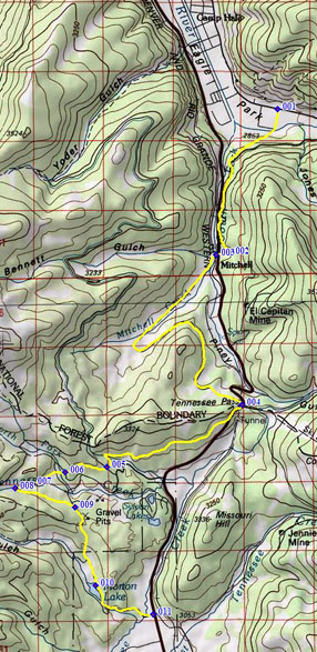
1.(9340ft,mile00)
START-END NORTH: Colorado Trail turns left
onto FR741C before entering Camp Hale.
2.(10010ft,mile03) Colorado Trail shoulder
summit m139.9
3.(9970ft,mile03) Colorado Trail crosses
US24 on its way to Tennessee Pass. Profile
turns down US24.
4.(10424ft,mile08) CT Trailhead at top of
Tennessee Pass
5.(10420ft,mile10) CT crosses Wurts Ditch
Road
6.(10400ft,mile11) CT crosses Lily Lake
Road
7.(10390ft,mile11) CT crosses west fork of
Tennessee Creek on bridge
8.(10500ft,mile12) TOP: profile leaves
Colorado Trail by turning hard right onto
a jeep trail
9.(10350ft,mile13) profile stays
right/downhill at fork
10.(10060ft,mile14) route comes out at
Morton Lake
11.(9950ft,mile15) START-END SOUTH: US24 -
road to Morton Lake |
 Approaches Approaches
From North. The Colorado Trail leaves the
south end of Camp Hale by contouring up a hill and
then staying very close to Co24 up Tennessee Pass for
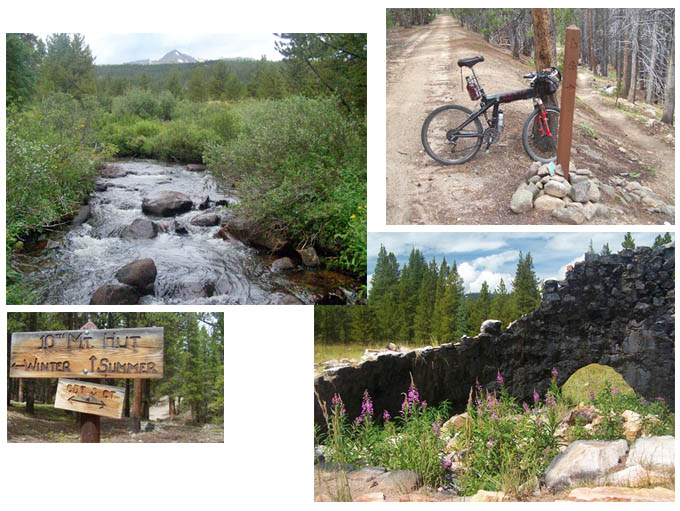
a couple of miles. Then the trail crosses the road
and also Tennessee Creek on two narrow, flattened
logs. During August its just a single step across
the creek and on the other side waits some of the
most pleasant mountain biking the Colorado Trail
has to offer.
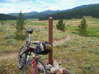
The trail skirts around a low, forested ridge and
enters a low valley separate from the Tennessee
Pass route. The Sawatch Range in the distance is
not at all the mighty wall, as in so many other
places. Here it's more the edge of a saucer,
surrounding verdant wetlands. In my opinion this
is the most beautiful spot along the entire route.
The biking is equally agreeable: no rocks, no deep
ruts, just cruising along the valley floor.
Eventually the trail does start to climb as it
enters the forest on the east side of the valley
and meanders to the top of Tennessee Pass.
The Colorado Trail continues on the same side of
the parking lot just a few feet further south.
Here it also picks up the Continental Divide
Trail, arriving from the east side of Tennessee
Pass. Continuing on the west side, a wide single
track leads through the forest that is also
heavily used by walkers. Fast progress is
possible. Between Tennessee Pass and the summit
point, the trail crosses two dirt roads Wurts
Ditch Road, and then Lily Lake Road. Both
intersections are elaborately signed in all
possible directions, with Colorado Trail and
Continental Divide Trail signs. These roads offer
more bikable ways back down without turning back
or using the more obscure southern approach
described here.
Progressing further away from the Lily Lake road,
sections of the trail now and then contain more
rocks and even a few sections that are better
walked. Glimpses of the mountains are limited to
when the trail crosses a creek tumbling down from
the Sawatch Range.
A small sign in the forest stating "old Mine", is
the last chance to make this into a loop ride
experience. This is also the highest point on the
route.
From South. (described downwards). From
here the rest of the Colorado Trail to the
wilderness boundary contains few, if any, easily
ridable sections and leads about a 100 feet
higher.
Turning to search for the way back down, the route
follows a wide track to an old car wreck in front
of a shack. Is that what is meant by Old Mine ?
Well, maybe there wasn't enough room on the sign
to say "Old Car Wreck and decrepit shack". In any
case, it is definitely clear, and that shows that
we have not strayed within the wilderness
boundaries.
As an aside, wouldn't it be nice if there was
something in between wilderness and junkyard, a
designation for public land where reasonable,
nondestructive uses such as bicycling are allowed,
but garbage and junk cars would be taken away (?)
Back to the route. Down valley from the car wreck
the wide trail soon turns into an abandoned road.
Actually it turns into something more than
abandoned, super abandoned or ultra super
abandoned. It is obvious that somebody, or more
likely or a whole group of people have taken it
upon themselves to help along the "abandoning
process" by placing whatever logs and obstacles
they could find across the path. This is obvious
because of the regular perpendicular placement,
and because many of them have smooth sawed ends. I
could only speculate about the reason for this.
First I thought that a something like this was
just abound crazy enough for a miner, who thought
he found something worth digging out back at the
old car wreck. Then later it occurred to me that
this could also be the result of the private land
owners surrounding Morton Lake, who took it upon
themselves to keep the public land free of ATVs
and other vehicles, so that they could enjoy their
peace and quiet around the lake.
After a short distance I discovered that it was
actually much easier to ride in the forest next to
the obstructed trail. This area was clear of
obstacles, since they had all been moved onto the
trail. After several miles, taking a right at a
junction leads to a short rocky sections where no
additional artificial abandonment was deemed
necessary, and soon the trail ends on an excellent
surface all weather dirt road, amongst the
cottages and houses on Morton Lake. Continuing
left on the dirt road leads to Co24 at its lowest
spot between Tennessee
Pass and Leadville.
Dayride
PARTIALLY PAVED / UNPAVED / SINGLE TRACK / BIKE
AND HIKE
Colorado Trail m148.8(sh) , Tennessee Pass ,
additional out and back : just north of
Camp Hale > Co24 south > begin Colorado
Trail where it crosses from east to west north of
pass > Tennessee Pass(shp) > Colorado Trail
m148.8(sh) <> out and back to border of
wilderness area >> down Long's Gulch >
Morton Lake > Tennessee Pass > Co24 back to
starting point: 36.2 miles with 2930ft of climbing
in 4:53hours (VDO MC1.0 m3: 11.8.22).
History
Cycling: An early guide book that
described part of the northern approach of this
route as an out and back ride between Tenneseee
Pass and the Collegiate Peaks wilderness area, was
Linda Gong and Gregg Bromka's "Mountain Biker's
Guide to Colorado", first published in 1994.
|