| |
| |
Monarch Pass
Monarch Pass is a typical American
highway through non typical, special American
mountains. The mountains are the Sawatch Range.
Books with lots of pictures often describe them as
the "backbone of the continent". The Sawatch Range
contains a total of 14 peaks over 14000 feet, not
to mention the continental divide. All of the
"14ers", the other paved pass, Independence Pass,
and several dirt road passes reaching over 12
thousand feet, are north of Monarch Pass. The
peaks immediately surrounding Monarch Pass are
"only" in the 12 thousand foot range. But then the
valley floor is also 2000ft lower here too. South
of Monarch Pass the range takes on a more rounded
appearance.
The road cuts through this landscape like a knife. But there are some great views along the way. During the summer months this road may also carry a lot of through going traffic, consisting of tourists towing double trailers, which they haven't learned how to drive properly.
From East. The profile starts on the
plains in Canyon City, and includes all of the
Arkansas Canyon. Near the entrance to the canyon
there is a climb, that is big enough, that you
could call it a separate summit. Many years ago
this was a great ride through a scenic canyon, but
with little or no shoulder. I don't know how the
traffic conditions are now. There is also an MTB
trail, partially up the now abandoned old DRG rail
line. Most people think of the pass as starting at
point 8, where US50 turns away from the flag lined
roadside businesses, advertising everything from
raft trips to ATV rentals on the sprawling
outskirts of Salida. US50 starts to climb the ever so gentle slope of
a huge alluvial fan, spread out around the canyon
of the upper Arkansas River. The road has a
shoulder that may be wide enough to place bicycle
wheels on, but is not enough to get out of, what
may be fairly heavy traffic in the summer.
Parallel CR220, south of the US50 lets you get
away from the traffic for 5 or 6 miles. Most of it
has a hard medalled surface with some dirt on top,
sufficient for many skinny tire bikes in an upward
direction. It is signed as a bicycle route. The
very top part of it is paved and separately
accessible. The access spot is easily recognized
in Maysville, by the old historic schoolhouse
below US50. 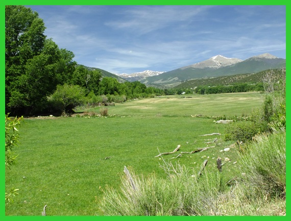 CR220 on the way to Monarch Pass The road stays at the bottom of the forested
canyon, passing. Maysfield and Garfielid were once
mining towns, and more recently, now failed
tourist businesses. "Garfield's only Mall" reads a
faded sign in front of a solitary sheet metal
building next to the road. Periodic climbing lanes
make traffic conditions more tolerable, but
increase the noise and smell, resulting from the
floored gaspedals. On the left side of the valley the mountain side
has been sacrificed to the Madonna Mine,
apparently a limestone quarry, that must be
several thousand feet high. Turning back, Mount
Shavano, a 14er with a unmistakable flat top,
remains in its natural beauty and grandeur.
The top contains a parking lot, apparently
anticipating large crowds. A small tourist lift
leads a few hundred feet higher. A souvenir store
greets the tourist with a onslaught of John Wayne
depictions, on the way to T-shirt and the souvenir
selection.
From West. (described downwards) The
curves are banked for high speed traffic. The
mountains above treeline have a smooth appearance,
no discernible edges. Ouray Peak, Pahlone Peak,
Mount Chipeta and other landforms all look
inviting for a walk up. They stand between here
and the next, more historic pass to the south, Marhsall Pass. The bike rolls into a landscape, more
characteristic of sagebrush western slope.
Approaching Sargents, a dirt road to the north
reunites Monarch Pass with its Old and Original
companions. This dirt road also goes to Tomichi Pass, an
extremely rough and scenic jeep trail pass.
Sargents itself contains a gas station with access
to a water source. To the south is the juction
with another convenient, unpaved pass back to the
starting point: Marshall
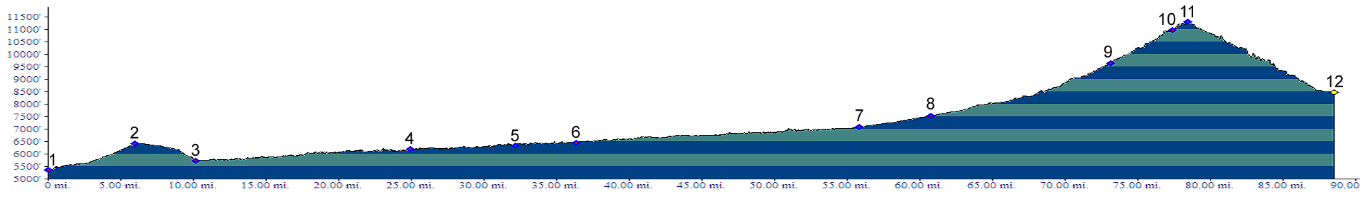
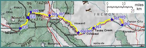
Pass. 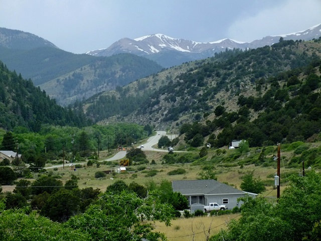 Dayride with this point as highest summit: ( < Hoosier Pass | Canyon Creek Trail s(u) > ) Monarch Pass , Marshall Pass : near jct FR200 - FR201, on eastside bottom of Marshall Pass > FR247 east > US285 north > Poncha Springs > US50 west > Monarch Pass > Sargents > Marshall Pass > back down to starting point: 65.2miles with 6130ft of climbing in 6:51 hrs (garmin etrex30 m5:18.6.4) Notes: strong headwind on Monarch Pass; two separate very close calls with pickup trucks, towing camping trailers and an additional trailer containing another boat or motor vehicle, by drivers with little or no idea of what they were towing and leaving about 4 inches of space on weekday in early June; slow leak front tire on second part of ride. Dayrides with this point as intermediate
summit are on page: History Leadville Mining Boom: While today's
highway crossing has only a recent history, the
nearby crossing of the same ridge line over
Original Monarch Pass dates back to the times when
miners carved trails without filing environmental
impact statements. This crossing was first used
regularly after miners ascended a small branch of
the South Arkansas River, crossed the divide and
founded the mining camps of White Pine and Tomichi
on the other side. By spring of 1881 a stage
crossed the pass on a daily basis from Garfield to
Pitkin, also crossing the low Waunita Pass.
Cycling - Ride the Rockies: (< Cerro Summit |
Rabbit Ears Pass
>); Between its first tour in 87 and 2005, the
pass has been part of the Denver Post's "Ride the
Rockies" during 87 89 92 97 99 and 02. The day's
ride was Gunnsion to Salida or Buena Vista.
|
||||||||||||||||||||||||||||||||||||||||||||||||||||||||||||
 Approaches
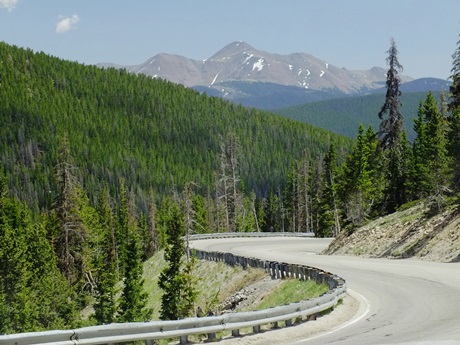 The area around Salida is
notoriously dry in the winter. So a ski area
around here has to be at a high altitude. When the
turnoff to Ski-Monarch comes up, the first 180
degree turns start the final ascent to the summit.
At the ski area is also the unsigned turnoff to
Original Monarch Pass, half a mile below that a
signed turnoff to Old Monarch Pass. "Original" was
first and is highest, was pioneered by miners, and
became a stage route. "Old" came next and is in
elevation between the two. Other mountain bike
routes, that branch off to the south further down
are
The area around Salida is
notoriously dry in the winter. So a ski area
around here has to be at a high altitude. When the
turnoff to Ski-Monarch comes up, the first 180
degree turns start the final ascent to the summit.
At the ski area is also the unsigned turnoff to
Original Monarch Pass, half a mile below that a
signed turnoff to Old Monarch Pass. "Original" was
first and is highest, was pioneered by miners, and
became a stage route. "Old" came next and is in
elevation between the two. Other mountain bike
routes, that branch off to the south further down
are 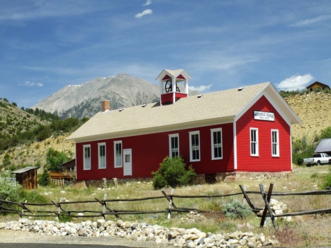 Modern Highways ( <
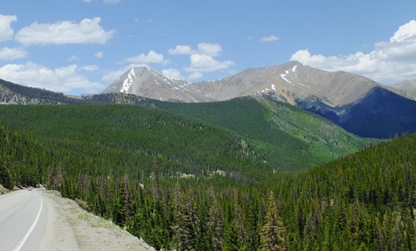
|
|
advertisement |
|
|
advertisement |