| |
| |
FR869 Toll Road Gulch s(u) aka Squirrel Creek Road This historic Otto Mears Toll
road is not mentioned in books that deal with
the history of Rocky Mountain passes. At least I
can't find any. Maybe that's because this
pass between Silver Creek and Squirrel Creek
(flowing into Kerber Creek) never got the formal
designation "pass" and a name to go along with
it. But it is displayed with a pass symbol is on
a map along the route. This surface of this jeep
road is more rideable than most, but steep in
places.
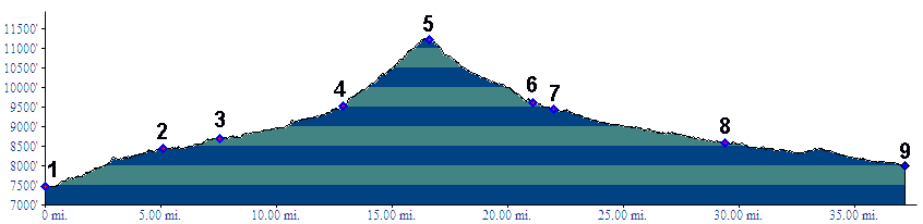
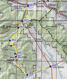
From North. To make it look big, the
profile starts out along the Poncha Pass road,
then branches onto the Marshall Pass road.
From the Shirley Site Trailhead the route follows
a good dirt road up Silver Creek. This road
becomes the Silver Creek Trail when the going gets
difficult, as the route tries to pass between
narrows with a formidable cliff on one side. Just
before the entrance to these cliffs, a sign points
up Toll Road Gulch, turning back in a northerly
direction. The initial very steep section soon
levels out a bit and becomes very rideable. After
considerable climbing the road seems to head for a
summit, but only on first sight. As the trees
clear for the first time, it becomes clear that
the view is of Mount Ouray to the north, that is
the same side we have been ascending. The summit area could already be seen from the
bottom. From down there it was just a little hard
to believe, that the straight line above a set of
cliffs on the side of Porphyry Peak was a road
cut. But from this new vantage point, it is in
better view and within reach. The road traverses
steeply, still in the trees, and becomes
increasingly rocky in places before it reaches the
road cut. The view is still of Mount Ouray, just a
lot better than from below. A few more yards and
the summit is reached. The view shed changes to
the area of Antora Peak. A sign indicates the
change from San Isabel to Rio Grande National
Forests. The road changes its name to Squirrel
Creek Road but retains its number 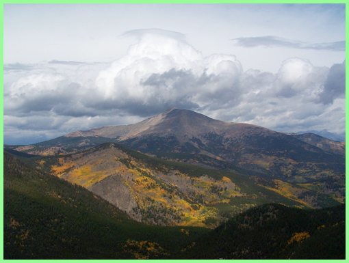 Mount Ouray from FR869 Toll Road, north side From South. (described downwards) The
descend in the trees soon reaches the Bonanza Mine
area, which is a junction for several forest
roads. An unusually detailed map sign at this
location, details several return possibilities
over summits to the east, heading for US285. This
is also the map that marks FR869 as a pass. Instead of returning over another summit the
profile goes lower to maximize the approach
height. A wide, all weather dirt road descends to
the town of Bonanza. This town is a mixture of old
mining era buildings, mostly in "uptown", with
newer constructions ranging from a few luxury
buildings to mostly mountain huts and trailers in
the "downtown" section. The straight, wide dirt
road continues and makes for fast travel all the
way to US285, intersecting it just north of Villa
Grove. Dayride with this point as highest summit: PARTIALLY PAVED / UNPAVED (<Colorado
Trail m272.1 s(u)|) |
 Approaches
|
|
advertisement |
|
|
advertisement |