| |
| |
Hayden Pass
I have often thought of the Sangre
de Cristo Range as the perfect combination of
Colorado landforms. It is a long fault block
range, a wall of mountains with pedestals made up
from alluvial fans. All of this is characteristic
of mountain ranges in the Intermountain west,
mostly to the west of Colorado. But the Sangre de
Cristo mountains also have the sculpted alpine
peaks that are more characteristic of northern
glaciated alpine mountains.
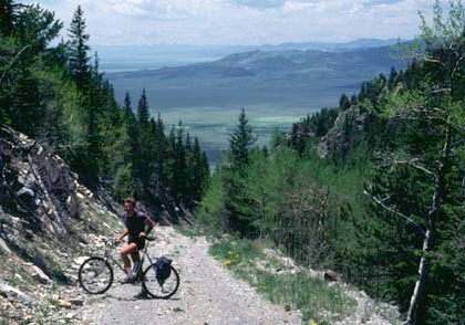
Unfortunately there is no perfect, bike friendly mountain pass through this range. Paved North La Veta Pass is a kind of race track for cars (even though combining it with unpaved Old La Veta Pass and Pass Creek Pass allows getting away from much of it). Mosca Pass is not legally accessible to through going bicycle traffic. Medano Pass is too sandy on the west side, and the jeep trail to Hermit Pass is such an ordeal, I have have never been able to get a bike over it. But I do know of two people who managed to do so, which included a long walk down the west side. This leaves Hayden Pass, and in comparison with the other options, its steepness may not seem quite as bad. One advantage - looking and finding some good views, a close distance from the road on the east side becomes more likely, since one is likely to be walking anyway. Hayden Pass barely reaches timberline, but hiking north from there immediately climbs above it. Hayden Pass is the northernmost
crossing the Sangre de Cristo Range, about 38
miles south east of Medano
Pass, which is even slightly than Hayden
Pass.
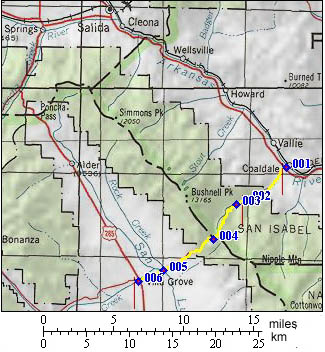
From East. From Coaldale a
paved road starts climbing an alluvial fan with
constant gradient, which is characteristic for
this range. By the time the Coaldale campground is
reached the surface has turned to a good dirt
road. The Rainbow trail crosses the Hayden Pass
road here, offering more MTB possibilities for the
rest of the weekend. From West. (also described
upwards) The small settlement of Villa Grove marks
the turnoff from US285 to the Hayden Pass road.
About half of the climb from this side is up a
large alluvial fan in sagebrush country, that gets
progressively steeper. Once you enter the forest,
the top is surprisingly close, compared to the
other side, but still quite a workout. 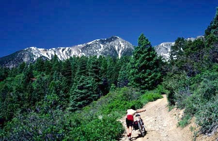 the start from Coaldale Campground is very steep History Hayden Pass has a long history for
westbound travelers who preferred to "lop off" the
northern part of the Sangre de Cristos instead of
detouring through today's Salida and the Arkansas
Valley. Already the Ute Indians used the pass. Hayden Survey (<Wolf Creek Pass|Mosca Pass>): In 1873 a subgroup of the Hayden survey examined the Sangre de Cristo Range south from Poncha Pass. The existence of the pass was duly noted by the group of surveyors. A road over the pass shortened the pack train distance from Canyon City up the Arkansas Canyon to Cochetopa Pass by thirty miles. The pass was already named after a different Hayden, not the director of the survey, but a Wet Mountain Valley settler who had pioneered the route, Lewis Hayden. To confuse matters further a third Hayden, a state geologist who surveyed the Sangre de Cristo Range for governor Gilpin in 1879 is sometimes also associated with the pass name. By 1879, a well used wagon road over the pass provided the option to substitute Hayden Pass for Poncha Pass, when traveling between the San Luis and Arkansas Valleys.
Cycling. An early mountain biking
guide, first published in 1987, mentions
Hayden Pass as being suitable for mountain
biking in its appendix, without describing
it any further (William L. Stoehr's:
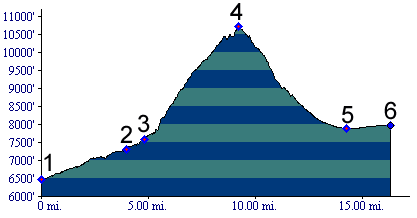
Bicycling the Backcountry). Dayride with this point as highest
summit: PARTIALLY PAVED / UNPAVED: Hayden Pass, Poncha Pass: Hayden Creek area > Hayden Pass > Villa Grove > US285 north > Poncha Pass > Poncha Springs > Salida > US50 south > back to starting point: 63 miles (mech Odo m1:87.6.13). |
 Approaches
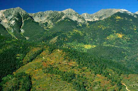
|
|
advertisement |
|
|
advertisement |