| |
| |
Medano Pass
The most troublesome aspect of
bicycling Medano Pass is not getting over the top.
Instead the hard labor and frustration comes when
traversing the bottom on the west side. The jeep
road through Great Sand Dunes National Monument
will make sandy parts of the Kokopelli Trail ( for
example ) appear like slickrock in comparison.
From West. As you follow Medano Creek into
Great Sand Dunes National Monument, you are
greeted by a sign, advising you to lower your tire
pressure to 50 percent of normal, to help deal
with the sand ahead. But of course this sign is
directed at jeepers. Grabbing the valve of one's
bicycle tire is of no use. A sturdy hike with a
bike by one's side lies ahead, maybe even a
portage, irregardless of tire pressure. By the
time Medano Creek turns into the mountains,
prayers for the end of sand are a likely
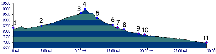
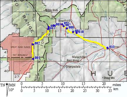
consequence for religeous MTBers. Yet the sand persists, even as you gain distance from the dunes. Once you get on the bike again, it's welcome relief to use the legs in a circular way and to ride in thick forest, and if it's snow melt time, next to a raging creek, that needs to be crossed numerous times. Near the top of the pass, an ( at least in the past ) unsigned junction may put you on the route to Mount Hierard. At this point, the Medano Pass summit is very close and east of the Mount Hierard Trail ( right fork going up towards the pass ). The top is in dense forest. From South. (also described upwards) The dirt road to Medano Pass leaves Rte 69 about a dozen miles south of the Promontory Divide. Compared with the other side, this is a pleasant ride indeed, even if the scenery is not as exotic, but beautiful nonetheless. The lower part of the route contains a few vantage points onto other peaks in the Sangre de Cristo Range to the south. A few miles below the summit the road turns into a trail curving through dense forest. Dayride PARTIALLY PAVED / UPAVED Medano Pass , Mosca Pass : lower western
approach to Mosca Pass > Mosca Pass > Great
Sand Dunes NM <> short out and back because
of wrong turn to Mt Hierard >> Medano Pass
> Co69 east > Garnder > back to starting
point: 52 miles (m1:87.05.09). History Pike (<Trout
Creek Pass|Mosca
Pass>): Having finally recognized
the Arkansas River for the Arkansas River, Pike
and his 14 men were camped in the Wet Mountain
Valley near Westcliffe. The piercing peaks of the
Crestones formed an impenetrable barrier to the
west, and the rounded Wet Mountains were to the
east. It was very cold spot to camp out that Januaray.
Pike an his men were in trouble. They were out of
food and close to freezing. Seven men collapsed
from frozen feet, including 3 official hunters. In
a 2 day hunt, bringing them very close to death,
Pike and another man succeeded in shooting a
buffalo. Shortly afterwards the weather moderated
and they crossed the Promontory Divide. Barely on
the other side, Pike spotted a another pass that
might lead him to the Red River. Another member of
his group had collapsed with frozen feet.
But what are somebody else's frozen feet to a 26
year old lieutenant following orders ? They left
him parked with some fire wood and headed across
Medano Pass. On the other side Pike was again convinced he had
found the Red River and ceremoniously drank from
the creek. He named the pass he just crossed
"Pike's Gap". But the Spanish had already given it
a more descriptive name "Medano Pass", Sanddune
Pass. To Pike's further dismay, his Red River
unceremoniously disappeared into the sand. Pike
spotted another river to the south near Alamosa,
but soon realized that it would lead him to the
Rio Grande and not the Red. Pike never mentioned
the massive southern terminus of the Sangre de
Cristo Mountains, the Blanca Massif in his
journals. That's understandable. He had other
problems, several men with frozen feet left behind
at a campsite on the other side of the pass, who
would be cripples the rest of their lives. In
order to retrace their way back to the camp in
front of the mountains, near Canyon City, some of
the group probably crossed Mosca Pass. Gunison Rail Survey (<Mosca Pass|Poncha Pass>) By
the time captain Gunnison surveyed Medano Pass for
its potential to serve as crossing for a future
transcontinental railroad, a broad Indian trail
traversed the pass. However the judgement for its
suitability as a railroad pass turned out even
worse than the previously surveyed route, Mosca Pass.
|
 Approaches
|
|
advertisement |
|
|
advertisement |