| |
| |
Loveland Pass Loveland Pass gets across the
obvious wall, that blocks the landscape some
distance west of Denver. It has always played an
important role in the life of the city. When there
was no easy way over this wall, it seemed to
play an even bigger role, because of the detours
it caused. - More about that in the history
section. These days the hole through the wall ( ie
Eisenhower tunnel ) is of bigger practical
importance than the pass. But that's just the
thing that makes the pass more interesting to
cyclists. With much of the traffic safely far
below, it becomes a more attractive cycling goal.
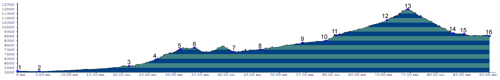
Loveland Pass is one of only two paved passes topping 12000 feet in the Colorado Front Range ( the other one is Trail Ridge Road ). - Okay, according to the list I checked Loveland Pass is 11992 feet, but if you're really tall, your head will be above 12000 feet.  Approaches From East. It is tempting to place the
beginning of the pass all the way back in Denver.
If you could cycle up from Golden on Rte6
following Clear Creek to where it joins I70, you
could also argue from a profile point of view,
that the pass starts this far east. However Rte6
is closed to cyclists (until the bike path is
finished), and even if it wasn't, heavy Central
City gambler traffic makes this road quite unsafe
at most times. Some people also feel that
the tunnels are an impediment to safe cycling.
This would be different in other countries where
cycling is more common phenomenon, 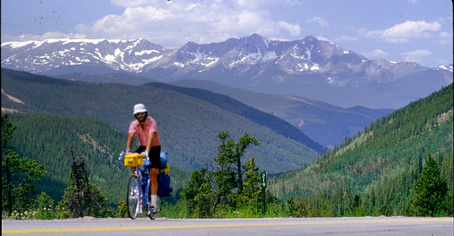 The description starts where the profile begins,
at the outskirts of Denver where Rte40 crosses I70
at exit 259. Rte40 parallels I70 up Mount Vernon
Canyon with a good shoulder and much of the
traffic safely removed on the Interstate. At
Genessee Park a bike path parallels the
Interstate. It is still legal to use the shoulder
of the Interstate - nice to know when snow blocks
the path. It is not maintained regularly. This
section only lasts two interstate exits. There are few signs to help negotiate the best
biking route along the interstate. But just
looking for the closest parallel route works good
enough, except for one exception, described later.
After the current section of the bike path ends,
the route continues US40 on the south side. US40
becomes quieter and puts some space between itself
and I70. At the top of the next noticeable climb,
the frontage road switches again to the north
side. The downhill from Floyd Hill
leads to exit 244, where I70 joins Clear Creek
Canyon and US from Golden. They are working on a
bike trail up that canyon, that someday will
replace the description up to this point.
Finding the continuation of the bike trail here
is very tricky - so tricky it must be some kind of
world record in trickiness. Generally speaking,
traffic participants are discouraged from entering
an Interstate highway in the wrong direction. Yet
here, it looks like this is exactly what you have
to do - go up the ramp of west-bound I25 exit.
Looking closely - there is also a lane in the
direction, leading apparently onto the highway in
the wrong direction. It is only 100ft or so long,
and then turns off toward the trailhead under an
overpass. There is also a biker route sign at this
second turn off. But you cannot see it from the
first turnoff. A combination of trails and service roads lead
into Idaho Springs. You can negotiate that
interesting old village by staying on a bike trail
on opposite side of I25, by taking a low-traffic
bike route through residential streets on the
north side of downtown, or just take in the
tourist shops and its ambiance along the main
street. The bikeroute leaves Idaho Springs north of the
Interstate, soon crosses onto the south side on
Standley road. In the next section there are
service roads on both sides. A wrong guess is not
a costly experience in miles or energy, either it
ends immediately or it goes all the way through.
At the juction with US40 to Berthould Pass, the
southern option carries far less traffic and makes
a better biking route. In Georgetown the
trick is to follow signs to the narrow gauge
railway station. Here another biketrail climbs the
impressive canyon to Silverplume, the other
terminus of the narrow gauge railway. When I first fist rode this route, Silverplume
meant that the cyclist had to come to terms with
exhaust and the smell of breakpads on the shoulder
of I70. But the situation has changed
dramatically. A bike path (again you have to
look for it) on the south side of the road leads
far from the higway through a green climbing
tunnel. It always surprises me to find so few
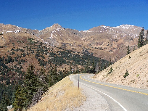
people using this great route. 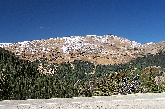 Looking for the entrance to the bikepath while
coming down Loveland Pass is again inevitable to
miss. But immediately afterwards the road leads
into the Interstate in the wrong direction. So
-again- this may be a hint that something is
not ideal about the
chosen route. Searching for a path a few hundred
feet before the momentuous occasion, will
eventually lead to finding the trailhead. After all those miles the passroad itself is just
a hop, skip and shift to the summit. Well - maybe
not. But at this point it's difficult to get lost,
and in comparison the actual passroad above
treeline really is very short on this side. Once
past the Loveland ski area, traverse leads above
treeline, and one or two switchbacks up the
conical shape of Mount Sniktau to the summit of
the pass. From West. (also described upwards) This
approach to Loveland Pass leads past the refined
cookie cutter architecture of ski resorts. I think
that in the summer this modern ghost town
atmosphere can have a certain appeal. Keystone is
left behind quickly as the road climbs steep and
straight, paralleling the North Fork of the Blue
River. Another ski resort appears, Arapahoe Basin,
before the final series of switchbacks coax the
rider to the top. 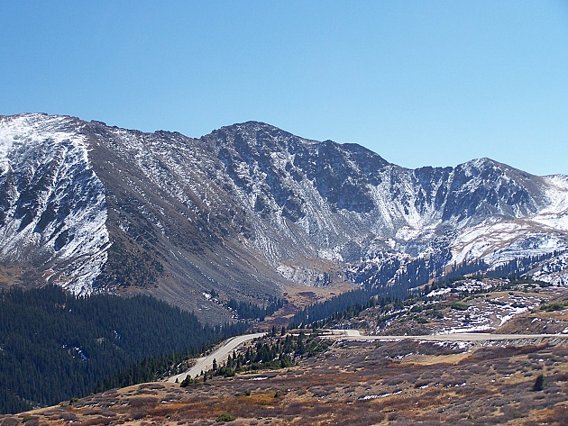
History Colorado Gold Rush of 1859/60 (<Georgia Pass|French Pass>):
Colorado miners did not cross Loveland Pass in
their search for gold. Instead they panned their
way completey around it, until they were 20 miles
from where they had started and the "Loveland Pass
ridge" separated the two points.
Leadville Boom (Fremont Pass>):
In 1878 the extend of the Leadville mining boom
started to become clear. The shortest route on
paper between Denver and the next pot of gold
still was directly over the divide. The Loveland
Pass Wagon Road was finally spurred into existence
by competition. The Tenmile Wagon Company was
building a road from Bakersville, up Grizzly
Gulch, heading for a crossing between Argentine Pass and
today's Loveland Pass, then still named Irwin
Pass. William Loveland responded by hiring a 100
men, and put his long hedged plan to cross the
divide on fast foward. The road suceeded where
Argentine Pass had failed and Webster Pass started
had to succeed. It became the dominant crossing of
the Continental Divide, and a very busy one at
that, because Leadville starting to enter
a boom period. Railroads (<Fremont
Pass|Blue Mesa
Summit>): This pass was never crossed by
a railroad. It still bears inclusion into this
thread - I think. The fact that no rails cross
Loveland Pass doesn't mean nobody tried.
Paradoxically a few remnants of the attempt are
still a tourist attraction, today's Georgetown
loop railway. In a way the story of rails entering the Colorado
mountains starts and ends with Loveland Pass. In
the beginning there were three competitors, the
DRG, the DSP and the Colorado Central and Pacific
railroad (DCP). Before there were any rails over
any passes, the DCP reached up North Clear Creek,
short of Central City in 1873. The DCP was UP
backed, and had grand schemes of crossing the
continental divide at Loveland Pass.
The UP mounted one more final assault, a line
direct from Denver across the mountains and across
Loveland Pass. The tracks reached within 8 miles
of the eastern foot of the pass. The first 3 miles
were such a maze of trestles and curves, that with
the help of some tourist hype, such as calling the
8th wonder of the world, it became a major tourist
attraction, even back in 1882. It remained a
tourist railroad till 1937. It would be
interesting to know if that is a world record
ratio for "time spent in real service" to "time
spent as a tourist railroad", a ratio that is
being enlarged with every day that the cute little
tourist railroad is in operation again, since the
1980s. For a period they were drawn by Shay piston
engines, a curious rare breed of steam engine that
has little resemblance to the original engines
that crossed the trestles during its extremely
short life. 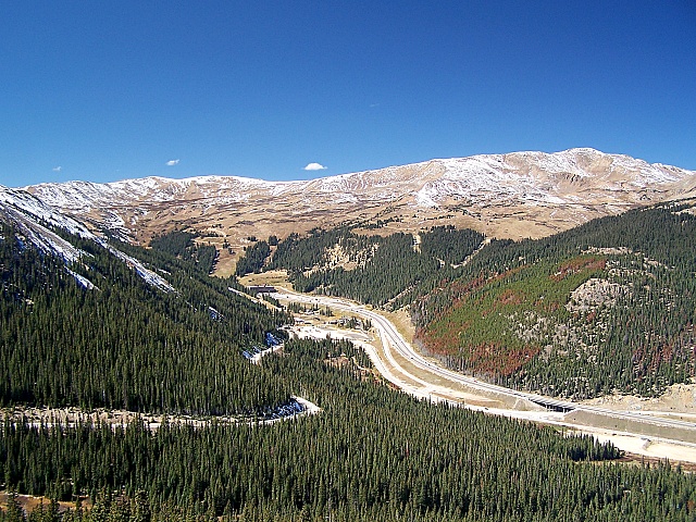 Cycling - Ride the Rockies: (<Fremont Pass|Blue Mesa Summit>).
No other pass is more closely identified with the
Denver Post's "Ride the Rockies" mass event than
Loveland Pass, in spite of the fact that Fremont
Pass has been crossed more frequently by this
tour. But Loveland Pass has provided the
exclamation mark at the end of the route. More
often than not, this ride ends with a massive
cycling invasion of the Denver area. In recent
years this has also happened over different
routes. But between 1986 and 2005, Loveland Pass
was still by far the most commonly used route, a
full 8 times ( 86 87 89 91 93 94 97 and 2004
). The stage has started in Frisco or Breckenridge
and ended in Idaho Springs, Golden, Denver or
Boulder. 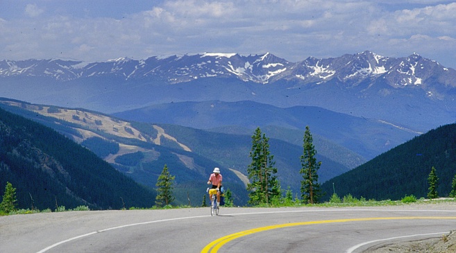 |
 There is
also a quarry at this point, so that the road is
often muddy from mud slurry on the the trucks, and
the bike ends up looking as if you were doing
gravel biking in a rainstorm.
There is
also a quarry at this point, so that the road is
often muddy from mud slurry on the the trucks, and
the bike ends up looking as if you were doing
gravel biking in a rainstorm.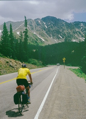 It had all started in Gregory
Gulch and the Idaho Springs area. Gold
seeking continued over
It had all started in Gregory
Gulch and the Idaho Springs area. Gold
seeking continued over |
|
advertisement |
|
|
advertisement |