| |
| |
Blue Mesa Summit
This pesky, not so little hill
shares appearance and size with many other less
famous mesa crossings, summits that have never
deserved the honor of a name. Blue Mesa Summit
made a name for itself in history as "son of a
bitch hill", a label that for some reason cannot
be found on today's maps. The history of Blue Mesa
Summit is distinguished from these other nameless
summits by having countless unlucky travelers sent
over it. For 150 years the Black Canyon of the
Gunnison has forced travelers to cross Blue Mesa
Summit rather than it. This remains until today
and includes bicyclists.
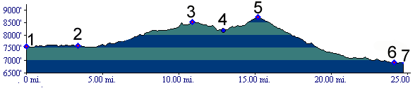
Blue Mesa Summit often comes as a surprise to cycle tourists along US50. The road, basically following the Gunnison River on its south side, is forced to detour around the jagged Black Canyon area and in the process climb this broad, sage covered plateau. The summit is not named on National Forest, highway or topo maps. But it is marked with a sign at the top.
From East. Starting the climb on a
already hot summer day, it actually gets hotter
with increasing elevation, instead of colder. The
reason is the disappearing cooling influence of
Curecanti Reservoir below. One short view of the
canyon appears on this side. After that the
scenery is dominated by sagebrush and industrial
strength campgrounds, featuring camping with
satellite dishes and rigs that expand like bloated
whales. The wide shoulder disappears as the road
approaches the first summit point (July/05). A steady climb leaves the town of Cimarron. There
is one other small store between the town and the
summit, before the road reaches a broad dip
between two hills. Looking back one can make out a
few peaks in the distant San Juan mountains as
well as the enormous plateau, through which the
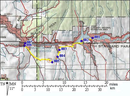
Gunnison River cut its famous canyon. Dayride with this point as highest summit (<Slumgullion
Pass|Black
Mesa Summit>) A Day on a 15 Day Tour with this point as
highest summit:
History Blue Mesa Summit has a long history as detour
around the Black Canyon, but not quite as long and
extensive as the next summit to the west, Cerro Summit
(even though lower in top elevation). More
happened deep below than on Blue Mesa's
nondescript top. This stretch of the canyon laid
the most convincing reasons on practically
motivated travelers and traffic planners to exit
the canyon while they still can. The western end
of the profile, Cimarron Canyon, provided the last
chance to emerge from the depths and travel trough
the sage instead. Gunsion Rail Survey (<Cochetopa Pass|Cerro Summit>): ...And everything was going so well on top of Cochetopa Pass. But then Captain Gunnison's assessment for a transcontinental railroad over Cochetopa Pass, following the Gunnison river westwards took a nosedive. Now he had to deal with the Black Canyon of the Gunnison. He would have much preferred the canyon route over crossing Blue Mesa. It was later, inside what is now the national park, that two of his wagons overturned, and the plans for a transcontinental railline also were destroyed. Still, the canyon would bear Gunnison's name in the future Otto Mears Passes (<Pinos Pass|Cerro Summit>),
also the San Juan Mining Boom. Otto Mears
acquired the route over the smmit as part of his
toll road kingdom shortly after 1875. In 1881
settlers poured over the pass to live on Ute
lands, vacated as a result of the mining boom in
the San Juans. Railroads (<Loveland
Pass|Cerro
Summit>): The town of Gunnison was the
second pot of gold won by the Denver Rio Grand
Railway (DRG). Just as in the race to Leadville,
the DRG's rails beat out the Denver South Park
railroad's (DSP) more mountainous route. But both
railways managed lay spur lines from Gunnison to
service the surrounding mines. No additional
passes needed to be crossed to do this. The DRG
serviced Crested Butte and its anthracite coal
deposits, while the DSP built a branch line
partly up Ohio Pass
to service its mines. In 1882 the DRG worked on expanding its line from
Gunnison to Salt Lake City. That was the occasion
for a railway through the Gunnison canyon to
become reality after all, albeit not all the way,
and only for a short time. While the DSP faced its
biggest nightmares on the mountain passes, the DRG
didn't have a picknick in the canyons either. Its
most difficult venture up to this point had been
the line through the Royal Gorge of the Arkansas.
Yet the last mile of rail through this part of the
Black Canyon cost the railroad more than then
entire right of way through the Royal Gorge.
Pioneering work in blasting techniques was done
here. Extra long fuses were deployed when workers
on scaffolding lowered into the canyon to set
charges. While the extra long fuses were burning
the workers would be hoisted out of the canyon.
Four months were needed to complete 15 miles
of track by 1043 men. The source does not specify
if the 1043 men refers to before the blasting
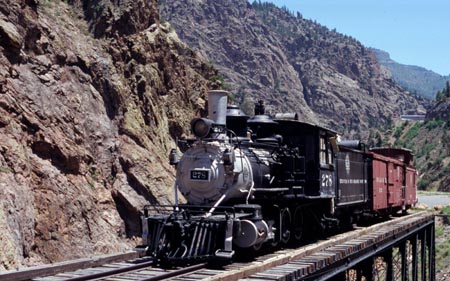
started or after it was finished. The rails burrowed through the canyon, exiting
along the west end of the profile provided on top.
Here began the climb through Cimarron Canyon on
its way up Cerro
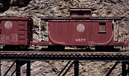
Summit. An engine with two cars sitting on a
partially restored bridge mark the spot today. The
National Park Service also provides a visitor
center complete with a park ranger, who can answer
any burning historical questions that just can't
wait any longer to be answered. In 1971 the canyon was viewed as being more
appropriate for water storage than a railline. The
Morrow Point Dam submerged the canyon upstream
from the point where the rails exited. Cycling - Ride the Rockies (<Loveland Pass|Cerro Summit>): This summit has seen more than its share of the Denver Post's "Ride the Rockies" cyclists labor to its top. Even though never given the recognition of a pass label on their official map, the summit has been on the tours of 1987 89 92 97 99 02 and 05, only once less than the pass that is most associated with this tour, Loveland Pass. All of these stages grouped Blue Mesa Summit with Cerro Summit.
|
||||||||||||||||||||||||||||||||||||||||||||||||||||||||
 Approaches
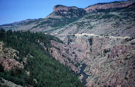
|
|
advertisement |
|
|
advertisement |