| |
| |
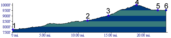
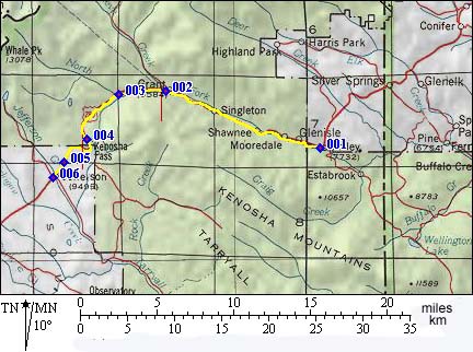
Kenosha Pass
Today Kenosha Pass is the highest
point on US285 between Denver and the Arkansas
Valley. The profile starts in Bailey. The road
between Bailey and the junction with Guanella Pass Rd
has no shoulder, heavy traffic that is not
disposed to slowing down, and is very dangerous,
even though it is open to bicycles. US285 as a
whole seems to bring out the worst in drivers. But
connecting Guanella Pass with Kenosha Pass is more
feasible - more below.
From East. I already mentioned the
terrible, horrible, deplorable, unmentionable,
unciviliced conditions between Bailey and the
junction with the Guanella
Pass Rd. But surprise, maybe 100 yards west of this
junction a fairly spacious shoulder starts. I
still wouldn't call this a "scenic climb", even
though having a rear view mirror helps helps. On
the profile the road does not appear very steep,
but the noise from all the passing cars having
their gas pedals floored may make it seem so. The shoulder disappears once to make room for a
climbing lane, but then reappears again. There are
no switchbacks on this major highway. At the top
the Colorado Trail crosses, and a sign hints at
the immense historic importance of this crossing From West. (described downwards). The
first impressive view of the immense soup bowl
that makes up South Park appears at the beginning
of the descent. The descent on this side is barely
500ft high and only consists of two sweeping
curves. There is an acceptable shoulder on this
side also, though not as wide as the upper eastern
side.
In a way Kenosha Pass is Denver's first I25 -
it's first traffic thoroughfare into the
mountains. Colorado Gold Rush of 1859/60(<Guanella Pass|Ute Pass>): Kenosha
Pass was already a Ute Indian Trail. After gold
had been discovered west of Denver in 1859,
prospectors arrived from Guanella Pass on
the east side of Kenosa Pass. In their frenzy,
they prospected themselves right over Kenosha Pass
into South Park. Here they were happy. Here they
located a major find. The diggings along Tarryall
Creek developed into a rush as big as the one in
existence already along Clear Creek. As consequence of the traffic generated to South
Park, Ute Pass
(from Colorado Springs) also played a role in the
gold rush, as early major supply route to the
Tarryall fields. But already the next year, an
extensive toll road system was in existence over
Kenosha Pass. Through the foothills east of
Kenosha Pass, miners could choose between three
toll roads, all of wich would funnel traffic into
the single crossing of Kenosha Pass. All of the
lower access roads avoided the unnavigable canyon
of the South Platte. Ute Pass was still free, but
also a lot further from Denver.
Leadville Boom(<Wilkerson Pass|Weston Pass>):
When the Leadville mining boom was heard around
the state, DSP (Denver South Park and Pacific
Railroad) rails reached up towards Kenosha Pass as
far as the current town of Bailey. The remaining
20 miles of wagon road were improved to handle the
increased traffic. Railroads(<Raton
Pass|Trout
Creek Pass>): The race was on. The finish
line was in Leadville. That's where the big pot of
silver was waiting. That's where the mining boom
was happening, and on the way there - railroads
had to cross mountain passes. Some railroads opted
for the high routes, others for the low routes. The previous instance of a railroad laying tracks
over a Colorado pass was the Santa Fe railroad
(SF) over Raton Pass. After that the Santa Fe was
done in the pass department. Now there were three
participants in this race to lay tracks over
Colorado passes, General Palmer's Denver Rio
Grande (DRG), Evans's Denver and South Park (DSP),
and Loveland's Colorado Central (CC). As if
that wasn't enough to remember, there is another
player worth mentioning, Jay Gould's huge Union
Pacific (UP). Jay Gould had made his empire
through bribery, stock manipulation and alleged
embezzlement. He wrecked the Eeire railroad
back east and ruined thousands of investors. He
also controlled the Kansas Pacific Railroad, and
he had his eyes on Colorado. Here goes the alphabet soup. DRG was caught up in
a war with SF at the base of the Royal Gorge for
two years, delaying progress to Leadville from
that part of the Front Range. UP was so large and
influential that CC became its pawn. Emperor UP
intimidated the only remaining player, the DSP,
with outlandish statements, publicized in
newspaper propaganda by leaders of CC. Sofar pawn
CC had reached as far as Georgetown. From there,
CC would swoop over Loveland
Pass with a rig combining the best features
of a tram and a ferris wheel. If that doesn't cede
the race for Leadville to the UP and its CC, UP
would reach a tentacle down from its Wyoming line,
through North Park, Middle Park and across Tennessee Pass,
something that sounded altogether more realistic.  Undeterred by these threads the DSP started
building from its terminus in Morrison, up Platte
Canyon towards Kenosha Pass. This was railroad
pass building on on a new larger scale, as far as
Colorado was concerned. Kenosha Pass was 600 feet
higher than North La Veta Pass. But that doensn't
even begin to describe the difference. The total
rise of the DSP line to the pass was 4711 feet.
The line ran up the Platte River all the way
(1879), something that no road ever managed to do.
This provides a more appealing definition for the
term "Kenosha Pass" than the one provided by the
current Highway 285. The most difficult part of
the route was a dynamited shelf route through
Platte Canyon, an area very close to Denver, a
canyon thankfully still without a highway and with
great dirt road bicycling. The DSP reached the top of the pass, still along
South Platte waters in 1879. The altitude gain of
the narrow gauge tracks, 4711 feet is impressive -
but not the most impressive. Rather it is the
speed with which they were constructed, their
transience, and the fact that they ran at all,
even if it was for just a short time. Once across the top, the gaily painted narrow
gauge trains happily chucked across South Park,
looking very much like a toy railroad, with their
diamond shaped smoke stacks, their huge headlights
emphasizing the tinyness of the engine itself. In
a way they not only looked like toy trains. They
were toy trains, toys that earned money for their
owners. But the DSP would not win the race to
Leadville, more details on the Trout Creek Pass
page. Modern Highways (<Molas Divide|Fall River Pass>):
Between the two world wars, the US engaged in a
road building frenzy. Kenosha Pass became part of
the "Hard Pan Triangle" touristic route connecting
Denver with Fairplay.
|
||||||||||||||||||||||||||||||||||||||||||||||||
 Approaches
 The Civil War Years: (<
|
|
advertisement |
|
|
advertisement |