| |
|
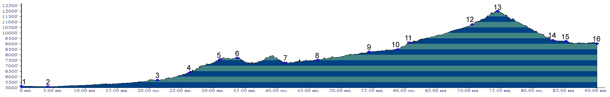
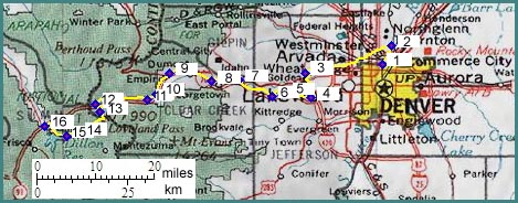
01.(mile00,5140ft) START-END EAST ALTERNATE: Denver, Confluence Park
02.(mile04,5100ft) turn from Platte River bikepath left onto bikepath following Clear Creek
03.(mile22,5680ft) START-END EAST ALTERNATE: downtown Golden
04.(mile27,6400ft) begin Mount Vernon Canyon, service road to I70
05.(mile31,7580ft) bike route joins I70
06.(mile34,7690ft) El Rancho, Squaw/Juniper Pass east end profile joins here; bike route exits I70
07.(mile41,7260ft) START-END EAST: rte6 I70 junction. Take the bikepath on the south side of Clear Creek
08.(mile47,7550ft) Idaho Springs, Squaw/Juniper Pass profile west end joins here. Bike route continues on service road crossing south of I70 at west edge of town.
09.(mile55,8270ft) Berthoud Pass profile joins here
10.(mile60,8570ft) downtown Georgetown, head for Georgetown Loop railway station to pick up bike path.
11.(mile61,9180ft) Silver Plume, bike route changes from bike path to service road, soon after that onto I70.
12.(mile71,10770ft) START-END EAST ALTERNATE: exit I70 for Loveland Pass road
13.(mile74,11998ft) TOP: Loveland Pass
14.(mile83,9350ft) Webster Pass profile joins here
15.(mile86,9250ft) START-END WEST: resort of Keystone
16.(mile90,9020ft) START-END WEST ALTERNATE : town of Dillon, Vail Pass profile joins here.