| |
| |
Weston Pass
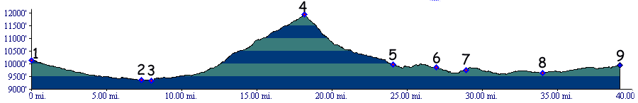
Weston Pass is a happy medium
when it comes to crossing the southern part of the
Mosquito Range. To the north is the rough and high
Mosquito Pass. To
the south US285 crosses Trout Creek Pass
with barely a curve or climb from South Park.
Between them a dirt road leads to magnificent
views onto the Sawatch Range with a great climbing
work out.
From West. Weston Pass leaves the Arkansas
Valley at a point roughly a thousand feet lower
than where the Mosquito
Pass road does. The additional approach from
Leadville to the turnoff is included in this
profile - only because a day of cycling over the
pass is much more likely to begin in Leadville
than at the turnoff. As the dirt road climbs, the
Mosquito Range presents a gentle picture, here
near its southern terminus, so that no switchbacks
are required. The real visual action takes place
across the Arkansas Valley, where 14ers form La
Plata Peak to Mount Massive lump together over
Twin Lakes. The road contains a few rocky
sections, alternating with smooth dirt formed into
big waves that may be a problem for anything on
four wheels but is fun on two. From East. (also described upwards) As you travel along
US285 through high and dry South Park, there are
two roads, that signs designate as approaches to
Weston Pass. One lends itself better for combining
this pass with Mosquito Pass, the other with
points south, like Trout Creek Pass or any of its
unpaved alternatives. The profile above contains
the northern approach, The two roads are
elaborately engineered dirt roads, the kind that
cars don't slow down for, and throw up clouds of
dust instead. Where they meet the road makes a
semicircle to the south, passes a campground and
finally starts climbing in hearnest, shedding its
high speed character and following the South
Fork of the South Platte River. For me the most
impressive view is from here looking up to the
pass, which from this perspective is dwarved by
the smooth, round shape of Ptamigan Peak to its
right. There are no switchbacks. Instead the road
becomes very steep.
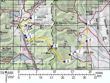
Dayrides with this point as highest summit: PARTIALLY PAVED/UNPAVED: Weston Pass, Trout
Creek Pass: campsite on FR187, a
few miles west of Trout Creek Pass > US285 east
> Trout Creek Pass > CR22 north west >
Weston Pass > US24 south > Buena Vista >
CR313 south > Johnson Village > US285 back
to starting point: 83.5miles with 5030ft of
climbing in 6:55hours (VDO MC1.0 m3.11.6.23). Dayrides with this point as intermediate
summit are on page: History Colorado Gold Rush of 1859/60(<Mosquito Pass|Cinnamon Pass>):
High mountain passes pioneered by gold seekers in
South Park radiate out like spokes from a wheel.
Yet the history of Weston Pass is distinctly
different from any onf them. Yes, prospectors did
pan on the South Park side as they did on all the
other major passes in the area. They also used
this pass to access California Gulch in the upper
Arkansas valley. But the major role of the pass
became its function as a wagon road supplying the
upper Arkansas, from Canyon City and Currant
Creek. Leadville Boom(<Kenosha
Pass|Mosquito
Pass>): When it came to supplying
Leadville and the upper Arkansas valley with
goods, Weston Pass was shorter than the more
obvious route over Trout
Creek Pass. And even though the Weston road
climbed much higher than Trout Creek Pass, you did
not have to descend into a much lower part of the
Arkansas valley, only to climb back out of it.
Additionally you saved about 30 miles in destance,
and bypassed a canyon shelf road between Trout
Creek Pass and Granite. During its heyday three different road companies
ran trails across the pass, even if the third
company only lasted for three years. In 1877
Hayden's atlas of the west still showed Weston
Pass as a major road and the route over Mosquito
Pass as "just a trail". Already in 1880 railroads,
reaching Leadville by different routes, took much
of the business. Iimprovements on the Mosquito Pass road
stole much of the remaining business. Cycling: An early mountain biking guide, first published in 1987 mentioned Weston Pass as being suitable for mountain biking in its appendix, without describing it any further (William L. Stoehr's: Bicycling the Backcountry). |
 Approaches
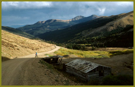
|
|
advertisement |
|
|
advertisement |