| |
| |
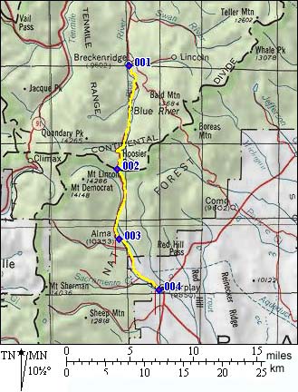
Hoosier Pass (Breckenridge
Area)
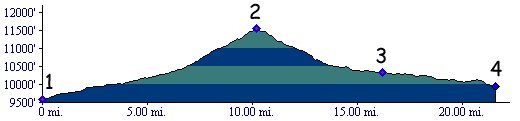
Hoosier Pass crosses from valley
of the Blue River in the south, to the highest of
Colorado's arid parks, South Park. For the road
cyclist it is the highest pass connecting with
South Park. Compared with other paved ways to exit
South Park, this climb is bigger, and it is also
lined with bigger mountain also.
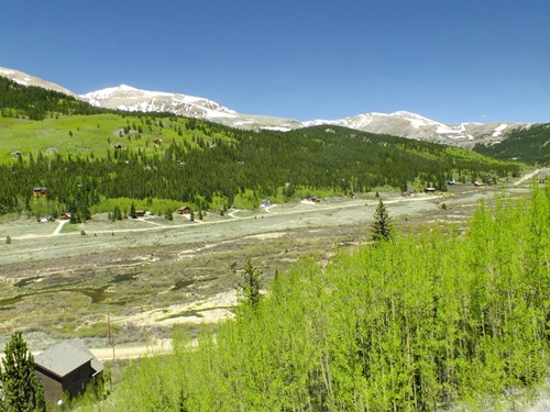
From North. Considering the amount of ski
terrain that is surrounding Breckenridge's Main
Street, its businesses are all of all fairly
"family sized". I mean to say - there are no high
rise hotel complexes in sight, like there would be
in Vail or Copper Mountain.The turnoff to the Boreas Pass Rd is one
traffic light south of the junction Main Street -
Co9. Co9 makes its way through suburbia-like summer
homes hidden in the forested slopes in safe
distance. Some are accessible through unpaved
county roads, others hide behind private
development entrances. During my last descend of this approach, on a
Friday afternoon in June, traffic conditions were
such that I was looking for a way to get away from
the traffic by detouring over some of these summer
cottage lined, unpaved county roads. Here is what
I found: A turnouff over Doris Dr, Reno Rd and
Quandary Dr. leads back to the main road on Co9
after a short distance. The relief from traffic
was appreciated, but only temporary. Also - on a mountain bike you can detour over Blue River Rd, the a single track trail on the west side of Goose Pasture Tam (a lake), and then continue through residential streets, avoiding most of the lower part of Co9 - a more substantial form of relief. But then - during most parts of the year, traffic is (hopefully) not so much a problem. After the summer homes come the switchbacks and
the gigantic snow lined mountains behind them. The
range to the west is the Tenmile Range, containing
a popular 14000 foot hiking destination, Mount
Quandary. The trailhead is on the top of the pass.
The summit also defines the continental divide.
The range on the west side of the pass changes
from Tenmile Range to the north (Pacific
watershed) to Mosquito Range in the south
(Atlantic watershed). The mountains to the east of
the pass tend to be more rounded and are part of
the Front Range.
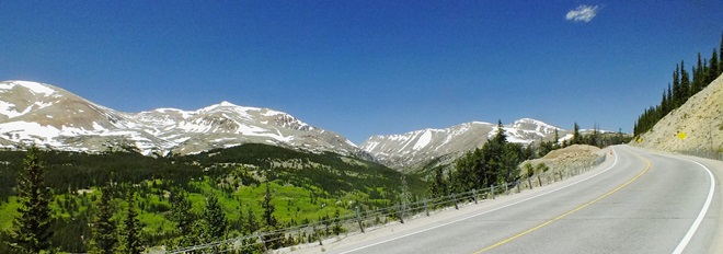
From South. (also described upwards). A
nice bikepath parallels the road from Fairplay to
Alma. In the left field of view the Mosquito Range
slides by, including peaks over 14000ft, Mounts
Lincoln, Democrat and Bross. The drainage up
Mosquito Gulch to Mosquito
Pass seems to be buried under snow, even
when the rest of the state is complaining of a
winter drought and the coming forest fire season. Unfortunately the bike path stops in Alma, but
surprisingly the traffic also becomes lighter. But
even more unfortunately, the rest of the road to
the summit is just perfect for cars, with barely
any turns. Traffic can be such, that drivers don't
see themselves compelled to slow down for cyclists
in oncoming traffic. It is a kind of crowd
mentality of 10 or more trailgating drivers. The last snow speckled mountains on the horizon
of the other side already belong to the Gore
Range. Real Estate agents also find the view
inspiring, the first objects can already be seen,
liberally sprinkled through the forest below, the
vaction and ski housing scene of Breckenridge. 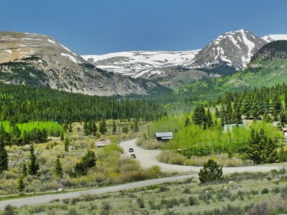 going up from Fairplay: view up Mosquito Gulch before reaching Alma History After its existence as a trail for Ute Indians,
word of the pass first reached back east from the
Pike expedition. He described the areas as the
headwaters of the Arkansas River. But he did not
explore them any further, believing that the
headwaters of the Yellowstone were just on the
other side. Fremont (<Muddy Pass|Currant Creek
Pass>): In the summer of 1844 a group of
former trappers, guides and traders, now part of
the US military under the command of Lieutenant
Fremont, surveyed a small part of Colorado for
possible immigration and military routes. Arriving
in the valley of the Blue River, continuing south,
Fremont had several passes to choose from. Georgia Pass was the
pass of choice in June of 1844. But it was being
used by Arapahoe Indians, apparently preparing for
war with Utes living in South Park. Fremont
crossed the range over today's Hoosier Pass,
estimating its height with his new barometer at
11200 feet, about 340 feet short of the actual
height. Entering South Park, Fremont realized that
he was in the drainage of the South Platte, which
was no small feat for the time. He exited South
Park by heading roughly for Currant Creek Pass. Colorado Gold Rush of 1859/60 (<French Pass|Mosquito Pass>):
In late 1860 the Colorado Gold Rush was in its
second year. During that year Hoosier Pass was one
of four passes crossing the mountains separating
South Park from the valley of the Blue River in
Breckenridge. Hoosier Pass was first prospected up
the existing Indian trail from the Breckenridge
side. Being natives of Indiana they called the
pass Hoosier, what else ? The miners promptly
described the pass as too unnavigable to be of any
use. But by 1861, at least nine wagons had crossed
over it. For the highest pass pioneered by miners
see Mosquito Pass. Modern Highways: Today's main connection
between South Park and the Blue River Valley took
many years to become just that. In 1864 the Denver
South Park railroad surveyed a route over the
pass. But it was eventually built over Boreas Pass. In 1866
the Union Pacific even received a recommendation
to use the pass for its transcontinental line. But
the UP's rails would bypass Colorado altogether.
Rails never crossed the pass. But cars did. By
1918 a good gravel road crossed the pass. The
gravel conditions lasted till at least 1962. Cycling-Ride the Rockies: (<Gore Pass|Hoosier Pass>): Between 1986 and 2005 the pass has been crossed once by the Denver Post's "Ride the Rockies" during 87, on a stage between Buena Vista and Breckenridge, which also included Trout Creek Pass. The previous day crossed Monarch Pass, while the following day was spent riding over Loveland Pass. The links, adjacent to the heading follow passes in order of how often they have been crossed by the Denver Post sponsored ride.
|
|||||||||||||||||||||||||||||||||||||||||||||||||||||||
 Approaches
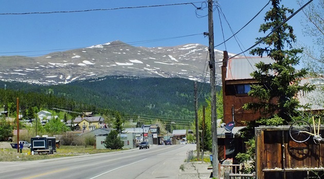
|
|
advertisement |
|
|
advertisement |