| |
| |
Boreas Pass
On a recent ride over the Colorado
Trail and Kenosha
Pass, I saw a historical sign on top of the
pass, that makes disparaging remarks about the
Denver and South Pacific Railroad. The sign called
the railroad - a failure - because it did not win
the "race" to build tracks to the destination
Leadville.
But - thanks to this railroad with limited commercial success, we have today's form of the Boreas Pass Rd, which was for a very short time the highest rail corridor in the United States. Even if a wagon road existed over the pass prior to this, the gentle grade of the rail crossing makes this a bike friendly route for all kinds of mountain bikers, including loaded tours. Measured in terms of time, that this route has been enjoyed by self powered travelers, the lifetime of the commercial venture of the railroad actually pales in comparison. Relative to one another, all the railroads, competing for traffic to Leadville went bankrupt, at more or less the same time. What is a decade when compared to the lifetime of a good cycling route ? In terms of cycling routes left for posterity, I nominate the Denver South Park and Pacific railroad as the clear winner - never mind Leadville. Not only did their little engines with over sized, brightly painted balloon smoke stacks pioneer the route over Boreas Pass. They also chugged up to the Alpine Tunnel and were the cause for the Williams Pass Road to be built (today a much rougher MTB route). Just imagine - in a perfect world, a bike trail would follow the old DSP route from Denver up South Platte Canyon - a route never followed by a road, then follow the old railroad grade on today's dangerous US285 from Denver up to Kenosha Pass, where a new sign would stand, acknowledging the fantastic cycling routes created by the Denver South Park and Pacific Railroad. The route down into South Park and the connection to the Boreas Pass Road would then just be the missing last link in the Grand DSP trail  The Boreas Pass Road is also open to licensed motor vehicles, but they don't seem to go much faster that the bicycles. Sure - the closeness of ski resort crowd in Breckenridge helps the popularity. But the scenery is special, and there are several authentic railroad artifacts along the route. The road itself is the result of a later army road building engineers in training project. Also - the lower part on each side, of what today is called "Boreas Pass Rd", does not follow the path of the rails. But that still leaves most of the road to follow this historic path.
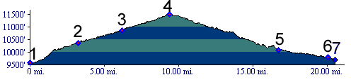
From North. Boreas Pass Rd intersects Co9
at the first traffic light south of town. There
are also other ways to connect with it, through
residential streets closer to the trailhead at the
end of the pavement. Right after the junction of
Co9 and Boreas Pass Rd, a railroad park displays
an old engine and several other railroad artifacts
from the Denver South Park and Pacific days.
According to the signs the engine traveled within
feet of its current resting place. But the rest of
the road to the trailhead clearly does not follow
anything that a train could travel. - It is much
too steep, and by the time the authentic Boreas
Pass rail route is reached at the trailhead, the
biggest part of the climb and the hardest workout
is actually over. But 49 percent or so still remain.
Continuing from here, a roadcut (or is that a
railcut) frames the Ten Mile range to perfection.
The road traverses up imaginatively named Bald
Mountain (13684ft) - passes an old restored
watertower - and finally reaches the summit in a
grand slice along the mountain. One would never guess that up to 150 people lived
up here on the summit to facilitate the operation
of the railroad. The section house, a kind of
hotel for railroad employees, has been or rebuilt.
An old freight car waits on a few yards of track
to be towed away. A number of tablets detail life
up here on Boreas Pass, named by the DSP executive
for its cold, "boreal" winds. It remains a moving
place.
Entering the foothills, the road passes the soul
of South Park, the Tarryall tailings, the mining
leftover, the historical waste product of the
mining boom, something that would be ugly, if it
were not so historical. Now it's historically
interesting in a somewhat disturbing kind of way. Signs lead the mountain biker to take the next
right up a "steep section" (that's what the sign
says), turning east. The profile does this, but
there is another way up, that stays along Taryall
Creek longer and with a much gentler slope. If I
was train, I surely would have taken the latter.
But the rail line followed a somewhat different
route altogether, sometimes touching upon today's
road. The two roads meet further up, roughly at
treeline, and from here the route to the pass is
obvious, not steep, and it compliments the bare
breadloaf Boreas Peak wonderfully. The
other side of the road shows off the steeper side
of Mount Silverheels.
Colorado Gold Rush of 1859/60 (<Red Hill Pass|Georgia Pass>): In the late summer of 1859 the gold rush of Colorado was still in its first year. The major center of gold activity in this area was Clear Creek in South Park, centered around Tarryall Creek on the south side. In the warm weather of late summer, gold seekers
became more mountain happy and crossed over to the
Blue River, calling the crossing Breckinridge
Pass, after Buchanan's vice president. The time
for choosing sides between the confederate slave
owning south, and the union north was getting
closer. The town's union Republicans learned that
vice president Breckinridge had joined the
confederate army. In an attempt to change the name
of the town but keeping the recognition factor on
their side, they renamed the town Breckenridge,
replacing an i with e. By August of next year the
route had been improved to a wagon road.
Railroads (<Cumbres
Pass|Fremont
Pass>) : The major markets to be served
by the railways had already been divided amongst
the victors. The DRG ( Denver Rio Grande ) ruled
Leadville, Gunnison and Durango. The DSP ( Denver
South Park and Pacific ) was now controlled
by the UP (Union Pacific). After successful hasty
construction to control a majority of the markets
by the DRG, the DSP wanted to build something too.
If nothing else it would generate business for the
parent, the UP, on which the DSP was heavily
dependent for construction materials Furthermore, mining prospects were bright on the
other side of the mountains, the area south of the
rim around South Park. The Kenosha Pass page
mentions how the DSP had conquered that pass, in
what seems half an eternity ago. Now business was
waiting on the other side of Breckenridge Pass.
The new name Boreas Pass was instituted during the
construction of the rail bed. It was chosen for
the north wind howling over the top. The pass was
also another step towards a competing railhead in
Leadville. It was not too long ago, that the UP
had helped the DRG to keep the DSP away from that
source of income (see Weston
Pass). Now that the UP controlled the DSP,
it had to cross not only Boreas Pass on its way to
Leadville, but also Fremont
Pass.
Cycling. An
early mountain biking guide, first published
in 1987, describes a one way ride from Como to
Breckenridge over Boreas Pass as "ride rating:
moderate, skill level: beginning/
intermediate, and approximate ride time: 2.5
hours".(William L. Stoehr's: Bicycling the
Backcountry). Mountain bikes had no suspension
at that time. Dayrides with this point as intermediate summit are on pages: French Pass
|
 Approaches
 From South. (also described
upwards). Leaving behind the US285 racetrack, the
profile enters Como. Here the Denver South Park
Railroad had a roundhouse, to house the engines
for the climb to come. Even without getting off
the bike, you can see remnants of the structure on
the east side of the road at the edge of the vast
expanse of South Park. Next to it you can spot
another solitary buidling. Its symticallity and
length give it away as a railway station.
From South. (also described
upwards). Leaving behind the US285 racetrack, the
profile enters Como. Here the Denver South Park
Railroad had a roundhouse, to house the engines
for the climb to come. Even without getting off
the bike, you can see remnants of the structure on
the east side of the road at the edge of the vast
expanse of South Park. Next to it you can spot
another solitary buidling. Its symticallity and
length give it away as a railway station. History
|
|
advertisement |
|
|
advertisement |