| |
| |
Dallas Divide
Log fences zig zag through a
grove of yellow september aspen trees. Mount
Sneffels in the backdrop soon attracts more
attention than the zig zag fence and the radiant
trees. - For many years this scene was on a
favorite Colorado post cards. Last time I rode
this the fence was gone. But the mountains and the
beauty remain. These views are from the Dallas
Divide road, as any cyclist gasping for air, while
arriving at the top will surely notice.
This is not a ride passing through a closed in space between alpine towers. Instead carpets of scattered aspen trees recede to the foot of the Sneffels Wilderness five miles in the distance. Located on the northern end of the Sneffels Range foothills, the Dallas Divide is also the lowest paved pass in the San Juan mountains.
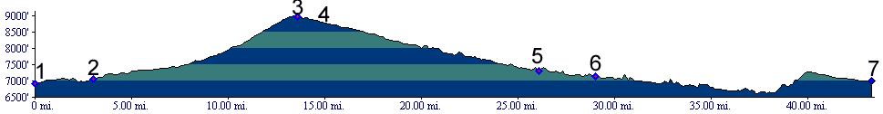
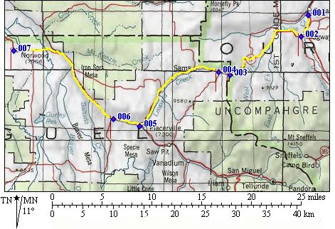
From East: A bikepath exists between the
housing development at Dallas and Ridgway. It does
however contain a 600 feet rough dirt section
(July/05), which is no problem for a fat tire
bike, but may impose uncalled for indignities on
very skinny tires. The initial steep climb from Ridgway proves
to be a false alarm. The road levels out soon
afterwards, and continues to follow Dallas Creek.
Moments later Mount Sneffels appears in view and a
variation of this sight accompanies the cyclist to
the top. The shoulder to be crossed at the summit
also becomes visible. The road climbs a small
ridge and one is tempted to think that God placed
the ridge at this point, so that man might have a
good viewing angle of the Sneffels massif. The
road has a good shoulder although it becomes a
little narrower towards the top.
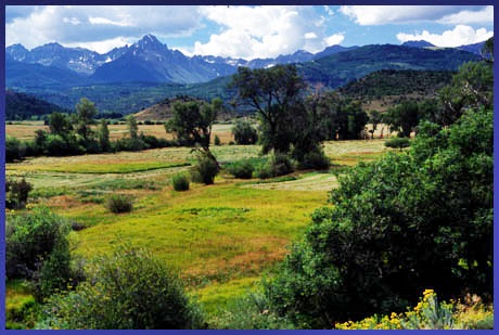
The ride from Ridgway makes me wish sometimes it
would last just a little longer, even if I have
seen it all before. Several views popularized by
post cards are all taken on this side. On the
upper stretch the San Juan Mountains look their
most sanjuanine - very different from other high
peaks like the alps. They have by more color,
straight sedimentary rock layers streaked with
ocher and red, and more aspsen leading up to them.
Straight cliffs lead to block shaped mountains.
Some have a flat top. Others are a ragged
ridgeline. From West: (also described upwards)
Riding up the pass from the west, the day's
journey is more likely to start in Telluride,
rather than the low point shown on the profile -
Norwood. The lowest elevation between Telluride
and the Dallas Divide is comes in Placerville, as
you turn onto Rte 62. From there it is only about
10 miles without switchbacks to the top. Past
Placerville the ride leaves the San Miguel river.
The road stays in the forest and offers little in
the way of views. The road has more shoulder than
the stretch Placerville - Telluride, which is part
of the Lizard Head
Pass profile. Dayrides with this
point as intermediate summit are on pages:
Imogene
Pass Dayrides with this point as shoulder point are
on pages: A Day on a 15 day Tour: COMPLETELY PAVED (|Lizard
Head Pass>)
History Escalante (<Gypsum
Pass|Columbine
Pass>): At the point where the first
picture was taken an informational tablet erected
by the Old Spanish Trail Association states that
the Escalante expedition of 1776 crossed the
Dallas Divide. One has to assume that "Dallas
Divide" in this context refers to the water divide
that continues onto the Uncompaghre Plateau, and
not this particular crossing. Several proposals
have been made just exactly where Dominguez and
Escalante crossed from the San Miguel to the
Gunnision drainages. This is one of them, Columbine Pass is
another. Railroads(<Hesperus
Pass|Lizard
Head Pass>): also Otto Mears Passes.
The Dallas Divide is the beginning of the final
chapter of narrow gauge rail passes in
Colorado. Otto Mears' first attempt to
provide a rail connection between Silverton and
Ouray over Red
Mountain Pass had failed. Plan B, the big
detour was conceived, a plan to cross Lizard Head Pass
and the Dallas Divide to connect Durango with
today's Ridgway. 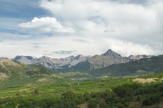 The railroad imprinted the name on today's
Ridgway. When iron tracks came close to already
existing pioneer towns of the American west,
upheaval was sure to follow. Often a new town was
platted from railroad property, in order to
maximize windfall profits. In this case the already existing town was also
renamed due to additional factors, leading to a
virtual renaming frenzy. In the 1870s the
community of Unaweep, an Indian word for "dividing
waters" was located just south of the official Ute
territory boundary, just north of today's Ridgway.
After the Meeker massacre near Yellowjacket
Pass, popular sentiment turned against
Indian names and the town became Dallasville in
1979. It grew into Dallas City with the passing of
Denver Rio Grande rails between Durango and Ouray.
When Mears' Rio Grand Southern chose the area as
the northern terminus for his final bravado
project, the nearby Dallas Junction became the new
center of Ridgway, named of course after the
superintendent of the railway's new northern
division. Today old Dallas City is witnessing a rebirth
under the name Dallas. A golf course has been
built to attract development, the kind of place
that the Arizona dessert is famous for. These days
retiring seniors flock to these oasi just like
caravans of traveling beduins were attracted by
the original dessert oasi. While being originally
named for an old president, it may soon seem as if
Dallas was named after that city in Texas. But as
of yet, it is really not that bad. So much about Misters Ridgway and Dallas and the
towns named after them. From Ridgway the DRG
already operated tracks to Ouray. Now all that was
needed were tracks to from Ridgway to Durango.
This new line was called the Rio Grande Southern
and Otto Mears already operated a toll road over
the pass since 1882. Rail construction lasted
between 1889 and 1890, and once finished a post
office with train station graced the top of the
divide. But the major challenges lay still ahead,
Lizard Head Pass
and its canyons. 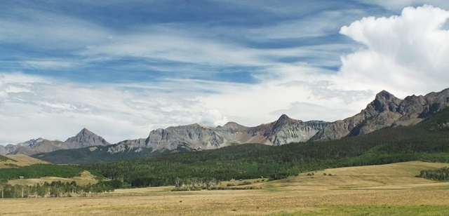 Cycling - Ride the Rockies: (<Cucharas Pass|Grand Mesa
summit(u)>): As of 2005 the Denver
Post's "Ride the Rockies" ventured twice over the
Dallas Divide, which is not a lot for such a great
cycling route. But then - the San Juans are far
from Denver. The city is usually one anchor of the
tour. The pass was included in 99 and 03 during a
stage from Telluride to Montrose.
|
|||||||||||||||||||||||||||||||||||||||||||||||
 Approaches
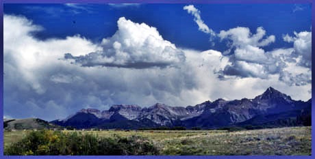
|
|
advertisement |
|
|
advertisement |