| |
| |
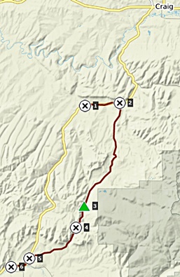
Yellowjacket Pass (Meeker
area)
This road has a perfect surface for a fast gravel
road ride. Actually, there really is very little
gravel, and lots of hard medalled surface, that
would even work for most road bikes. The scenery
consists of initial hogback ridges, the north
western boundary of the Colorado Plateau, which can
be pretty spectacular during the colors of October
(in previous years - September, but the seasons, the
are a changin). - Makes a great dayloop with Nine
Mile Gap s(u).
From North. The turnoff from Co13 is
clearly signed. This approach goes over two
additional high points. They loose close to 300ft
each before climbing to the next summit. If I
could find any roads that would permit an
additional 200ft of descending, I would count them
as separate summits. But I can't. The road over these first two summit points is
also the most interesting part of the ride, in my
opinion. Near the top of the first, Monument
Butte serves as landmark for the Axial Basin south
of here. Especially just before sunset the view
from here can be a geometrical wonderland. From the second high point, all the hogback
ridges towards the north line up like big stairs.
Unfortunately during Oct 20, this was still a
smoky pleasure. Rolling down from here the road
passes a memorial gazebo with informational
displays, regarding Thornburg. During Oct 20 it
was locked with a large gate, fence and padlock. A
little later a sign marks the Milk Creek massacre
(see history below). Another smooth surface climb, this time a little
bigger, and the pass is reached. There is no sign
or other indication, other than a change of
viewshed. From South. (described downwards). In
contrast to the other side, there is only one
short interruption in the lightning fast descend
between hogback ridges, due to a tiny climb. The
last miles are on pavement and in open ranch
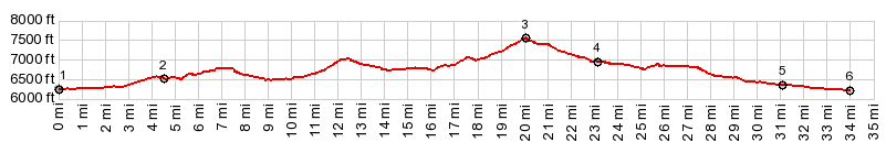
country. 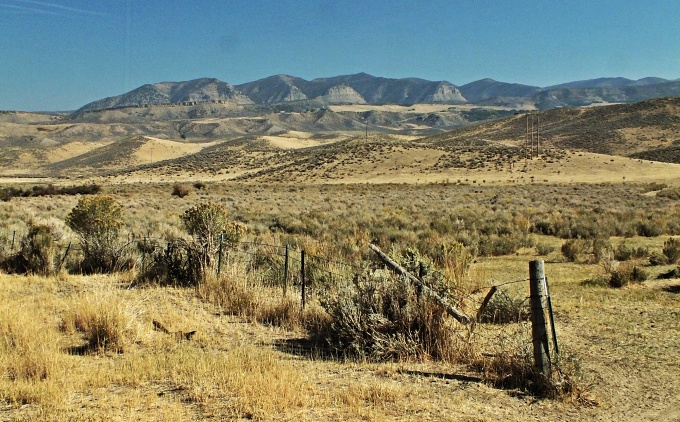 Dayrides with this point as highest summit PARTIALLY PAVED / UNPAVED A ride over Lynx Pass to Oak Creek, then returnning to the starting point over Yellowjacket Pass measured 75 miles with a rubber band driven odometer (m1:88.09.25). Yellowjacket Pass (Meeker) , Nine Mile Gap s(u) , additional out and back: Monument Butte area on CR45 > CR45 south > Yellowjacket Pass > CR15 south > jct with Co13 <> out and back to Meeker >> Co13 north > Nine Mile Gap s(u) > Co13 north > jct with CR45 <> out and back to Hamilton >> back to starting point on CR45: 74.1miles with 3740ft of climbing in 5:36hrs (m2:1.9.6) ( < CR45
Dry Mountain Rd s(u) | > ) same summit points , additional out and back:
CR17 Axial Basin, a few miles from its jct
with CR51 > CR17 south > CR51 south
> Co13 north > CR45 south > Yellowjacket
Pass > CR15 south > Co13 north > Nine
Mile Gap s(u) > CR17 north > back to
starting point on CR51: 64.1miles with 4270ft of
climbing in 5:21hrs (garmin etrex30 m3:20.10.3) 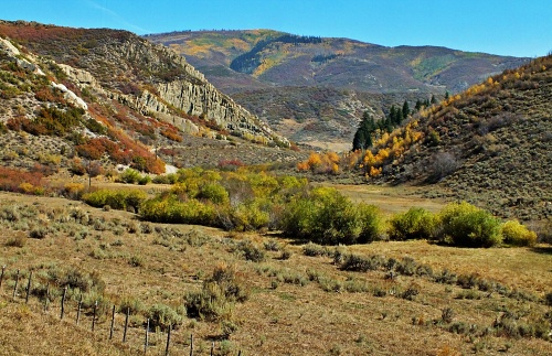 History Hayden Survey (<Battle
Hill Summit|Ellwood
Pass>): After mapping the lakes of the
Flattops southeast of here, the Hayden exited
Colorado over this pass in 1873. At the time the
pass was part of the Denver-Salt Lake stage route. The Civil War Years (<Gore
Pass|Raton
Pass>): Before the Civil War, fear of
isolation prompted the investigation of several
passes routes connecting with Denver. The most
important of these was a Denver to Salt Lake stage
route, investigated by the COC stage company, with
the help of Jim Bridger and Edward Berthoud. This
route entered Middle Park over Gore Pass and
exited it over Yellowjacket Pass. From there int
continued through present day Meeker along the
White River into Utah and onwards to Salt Lake
City. The Leadville Boom ( < Pearl Pass | Cochetopa Pass
> ): Parallel to the mining boom that started
in Leadville and spread westwards to the Aspen
area and further into the wild San Juans, runs the
story of the eviction of the Utes from their
ancestral lands. When gold was first disovered in the
Denver, Golden area these millions of acres of
mountains steams and meadows were enough to keep a
relatively peaceful environment between white
prospectors and what is estimated to be about 3500
Ute indians in the mountains. Still, conflict was
as sure to develop as death itself. In 1863 chief
Ouray, nominal leader of six bands of Utes, was
given possession of the Gunnison and Uncompagre
valleys. Five year later chief Ouray went to
Denver for clarification on the issue and received
the most generous amount of land ever (not)
appropriated by the government, approximately 4500
acres for every Ute man, woman and child. It was
an area bounded by the state borders of Utah, New
Mexico and the 107th parallel. It runs slightly
west of Aspen to Gunnison and Gypsum. The northern
boundary was theYampa River. By 1873 the Leadville (mining) boom
was at its Climax. Chief Ouray signed away land
occupied by prospectors at the agency at the base
of Pinos Pass and moved to the Uncompagre Valley.
The San Juan mountains and the Elk mountains were
now open for business. The Utes officially
retained hunting previledges and were introduced
to the concept of farming. They were entitled to
25000 dollars of farming equipment a year. In 1879 this clash between two
cultures, the Ute hunting tradition, and the white
farming tradition would lead to the definition of
the property lines the way they are today, in a
very tragic way. You might expect trouble to occur
near Leadville. Leadville was the name of an
indian settlement "outside the reservation", near
what we call Leadville today, the "Oro City" -
gold city of the time. On the other side of the
ellusive 107th parallel prospectors rumaged
through Aspen valleys looking for signs of gold.
Yet the final culminating set of events
surprisingly happened in an area, that has no
mineral wealth, where no prospectors were, no
gambling or mining towns stood, The town of Meeker
at the base of Yellowjacket Pass still looks like
one of the most isolated rural settlements left in
a Colorado, devoid of today's ski resorts and jet
tourism. It was still three years before the
incredible Pearl Pass
road was put into operation.
Running the agency was a family
business for the 60 year old Meeker. His 62 year
old wife ran the post office and his twenty one
year old daughter the agency boarding house and
school. It was up to Nathan to make sure that the
Utes conformed to his idea of farming, the basis
for other great inventions such as barbed wire,
sawmills, proper homes, stoves and the like. The conflict erupted over ponies.
The Utes liked to race in contests with other Ute
bands. Nathan Meeker on the other hand was of the
opinion, that they required far too much land,
that would be put to better use plowed up.
Meeker's suggestion that the Utes kill some ponys
resulted in physical violence and reinforcements
arriving from Fort Casper, in the form of a column
of army troops headed by Major Thornburgh. An
Indian chief had called on the major not to enter
the reservation past Milk Creek and received such
insurance. When this happened anyway hostilities
errupted.The 13 killed soldiers were far
outnumbered by the 250 killed horses and mules,
who were the center of the conflict in the first
place. Today north of the summit of
Yellowjacket Pass the battle of blood is
memorialized by a battle of competing monuments.
The place is the closest that Yellowjacket Pass
comes to the southern base of Thornburgh
Mountains, where the ambush occurred. A large
stone monument mourns Thornburgh and his dead. A
smaller subsequently errected monument mourns the
Utes and their dead. Currently no single monument
mourns all the dead. Subsequently back at the ranch,
Meeker and his employees were murdered, his wife
and daughter abducted to a hiding place on Grand
Mesa. A week long siege was finally ended by a
force of 850 men. The leading chief of the Utes,
Chief Douglas was sent to jail in Fort Leavenworth
for a year. Douglas had tended to agree with
Meeker. His subchiefs and medicine man were the
head of the anti farming pro pony racing
contingent. All this was welcome news for people
such as Denver Tribune reporter William Vickers
who had been looking for reasons to get rid of
Utes for years. Not only did the White River Utes
withdraw to Utah, so also did Chief Ouray vacate
his farm at the foot of the San Juans. The town of
Meeker started up in 1883, right after the army
removed the garrison it had placed there after the
massacre. 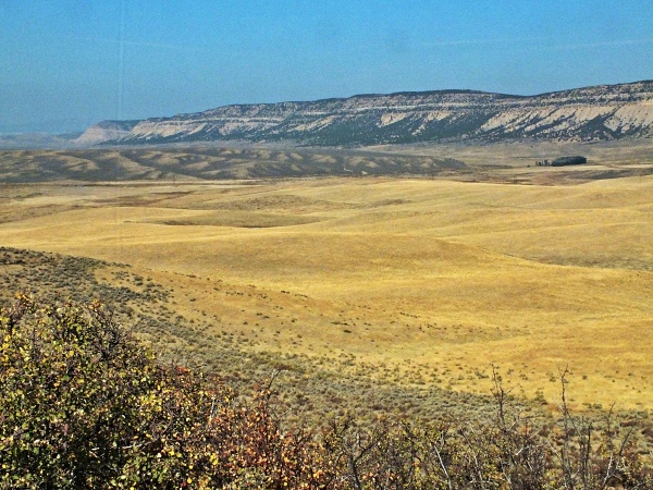 |
 Approaches
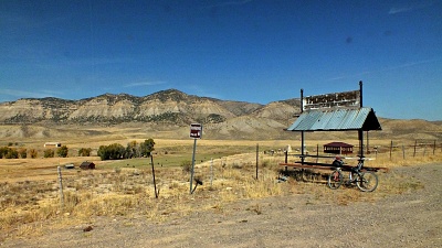 In 1879 Nathan Cooke
Meeker had been deprived of his postion as leader
of the Union Colony in Greeley. Through a set of
mysterious circumstances he was offered a position
as agent in the White River Ute agency. The agency
was located in Agency Park. The fertile White
River bottoms are traversed by the Meeker Buford
road and can be part of an overnight ride over the
In 1879 Nathan Cooke
Meeker had been deprived of his postion as leader
of the Union Colony in Greeley. Through a set of
mysterious circumstances he was offered a position
as agent in the White River Ute agency. The agency
was located in Agency Park. The fertile White
River bottoms are traversed by the Meeker Buford
road and can be part of an overnight ride over the
|
|
advertisement |
|
|
advertisement |