| |
| |
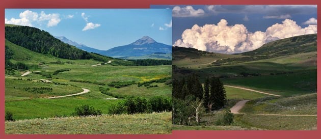
Hastings Mesa
summit(u)
 On
a bicycle there are at least three options to
connect Ridgway with Telluride: the long and paved
Dallas Divide, the
steep and slightly shorter, unpaved, more scenic Last Dollar Pass
( that route also includes the Dallas Divide as well
as this summit ), or the medium between the two,
the route over 58.p road. And that's this route
over Hastings Mesa summit(u). On
a bicycle there are at least three options to
connect Ridgway with Telluride: the long and paved
Dallas Divide, the
steep and slightly shorter, unpaved, more scenic Last Dollar Pass
( that route also includes the Dallas Divide as well
as this summit ), or the medium between the two,
the route over 58.p road. And that's this route
over Hastings Mesa summit(u).This is a good all weather dirt road. When I rode it last, I encountered no evils, such as deep gravel and dusty, banked high speed turns. The Telluride side of the summit also goes to the popular Last Dollar Pass. During my traversal of this route I encountered a total of about 9 cyclists in 3 groups on this side.
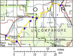
Approaches From North. 58.p road leaves
the Dallas Divide
road about 1+1/2 miles west of its summit at an
unsigned intersection. During the gradual climb
the southern end of the Sneffels mountains can be
glimpsed between the trees. Besides the usual
"ranch" like style of housing, there is also
something much more unusual ( and interesting), a
couple of houses with minimalistic beauty. One is
pictured below. Bigger is not always better (
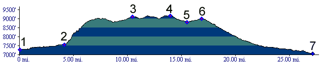
really ? ). The mesa consists of rolling hills
with a noticeable summit on each end. The point of
highest altitude it is difficult to determine
without measuring it. During the ride it felt like
it was located immediately north of a horse corral
and the turnoff to Last
Dollar Pass. But after consulting a map it
turns out be an inconspicuous point closer to the
center of the plateau. 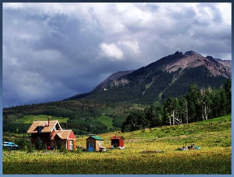 From South. The profile
begins downvalley in Ridgway to show a large
elevation gain, even though it is more often
approached from upvalley Telluride. The turnoff in
Sawpit is easily missed. It looks like a driveway.
After the first initial gasps of breath on a very
steep road a sign informs that the road is steep,
narrow and dangerous. Thank you for that bit of
information, even if the steepness was already
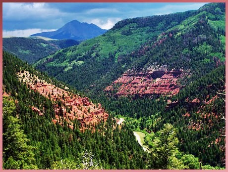
noticable. A few good views open onto the red
sedimentary rocks of the canyon carved by the San
Miguel River. The point of highest altitude comes
after miles of rolling mesa hills, that are much
cooler than the valleys.
PARTIALLY PAVED / UNPAVED: Hastings Mesa s(u) , Dallas Divide : Billy
Creek SWA > Ridgway > Dallas Divide > on
pavement to Sawpit > Hastings Mesa summit(u):
76 miles with 5700 feet of climbing in 6.2 hours
(Cateye 100AT m3:5.8.27) A ride from Ridgway over Last Dollar Pass
down Deep Creek, returning to the starting point
via Sawpit and this summit measured 60 miles with
6730ft of climbing in 5.3 hours using a Cateye
100AT cyclometer. This route also goes to the
summit of the Dallas
Divide twice, but skips its western approach
(m3:6.8.2).
|
|
|
advertisement |
|
|
advertisement |