| |
| |
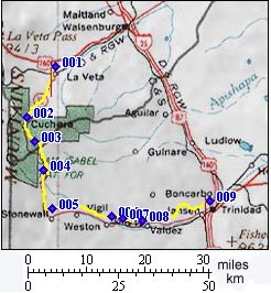
Cucharas Pass
The most unique scenic aspect of
this pass are the many volcanic dikes, which look
like straight stone walls, dividing the landscape
over hill and dale. They radiate out from the
Spanish Peaks like spokes on a wheel. Every now
and then you can catch a glimpse of the peaks
themselves too.
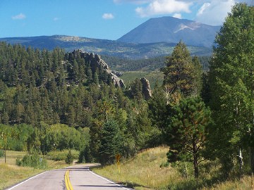
Cuchara(s) Pass crosses with the Spanish Peaks on one side (West Spanish Peak -13626ft and East Spanish Peak -12683ft) and the Culebra Range on the other side. The Culebra Range is part of the Sangre de Cristo Mountains. Or to be more specific, the road crosses between the foothills of these two areas. While most books name this crossing Cucharas Pass, many locals use the singular: Cuchara
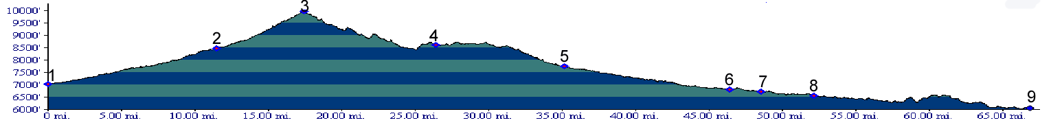
From North. You could argue that the most
impressive views of the Spanish Peaks themselves
are actually below from where the profile starts,
that is the section of US160 between Walsenburg
and La Veta. From here you see the maximum
elevation difference, The landscape is open range
country, so that the view is persistent enough to
be able to watch the various cloud formations form
around the peaks. Leaving US160 for Co12 to La
Veta, you have the impression of dropping down
into a valley. But checking this on the map, the
elevation loss is actually less than 100ft, and
that is much less than the 500-600 ft that the
route has been climbing since Walsenburg. Finally the elevation profile begins. Co12 leaves
La Veta in a combination of rectangular turns
along alnd boundaries. It crosses a field with the
last open view of the two breast like mountains to
the south. Roughly following Cuchara Creek, the
road comes very close to the lowest part of two
dikes, which descend to the creek in steps. With
only minor turns the road climbs gradually to the
village Cuchara, containing a few tourist
businesses. Now the gently gap in the dense forest
ahead is obvious, but the pass lies just a little
higher. The road climb climbs a little more
steeply now and uses a series of large radius
turns to get to the top. Surprisingly the road
leads by a subdivision development, maybe 700ft
below the summit. In the process of the climb from
the development Cuchara to the summit Cuchara, the
appearance of West Spanish Peak has changes from a
large pyramid to an small obtuse triangle, that is
cut off at the base by a line of aspen trees.
There is no view of high mountains from the
summit. But continuing on the dirt road to Cordova Pass
instead, soon gets to a view point
From South. (described downwards) When
you look at this pass from above (like from the
top of West Spanish Peak), you can hardly discern
the drop, the road makes on this side. But on a
bicycle it all looks different. The bike
definitely rolls down this side. But you barely
need to use brakes. It rolls into what seems like
an endless procession of green, forested hills.
The dikes seem to reach even further on this side,
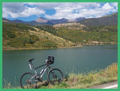
and they tend to parallel the road. As the road pulls two large radius curves at the
peaceful North Lake Reservoir, all surrounding
high peaks become visible again, the Spanish Peaks
and also a series of rounded molars reaching above
13000ft in the Culebra Range. Somwhere up there is
the old Whiskey Pass reaching over 12500ft. What
was an object of much tax spending in the form of
a WPA project in the 1930s is now for some bizarre
reason under private ownership, and what belongs
rightfully to the people - actually doesn't. That
would be one great bike ride. But back to Cuchara Pass. A full 17 miles as the
crow flies from West Spanish Peaks the dikes are
still alive and well. They even named a town after
one of them: Stonewall. A group of picturesque old
and new buildings shelter along the old volcanic
duct work, as if to seek shelter from wind. The paved road makes a 90 degree turn to the east
here, leaving the dyke area and heading for a more
regular variety of small wooded hills. Looking
back from the Elk Peak mine you can once more
catch a impressive view of the wall the east: the
Culebra Range and its Whiskey Pass. PARTIALLY PAVED / UNPAVED ( < Cordova Pass | Kerp Road s(u) > )
Cucharas Pass x2, additional out and back: FR415, a few miles east of Cucharas Pass > FR415 west > Cucharas Pass > Co12 south > Stonewall > jct with CR13.0 <> 5.4 mile (two way distance) out and back to turnaround point at Elk Peak Mine >> CR13.0 north > CR21.6 north > Co12 north > Cucharas Pass <> out and back down north side of Pass and 2 miles (total two way distance) up FR413 along Cucharas Creek >> back to starting point: 46.3miles with 4540ft of climbing in 4:24hrs (VDO MC1.0 m4:14.9.24). A Day on a Three Day Tour with this point as highest summit point: COMPLETELY PAVED: (<Greenhill Divide , Bigelow Divide , Wixson Divide , CR329 - 347 Rosita Rd s(u) |) Cucharas Pass: Walsenburg > US160 west > La Veta > Co12 south > Cucharas Pass > Stonewall > Trinidad: 79miles (mech Odo, m1:88.5.30) Notes: with DBTC, this three day tour required a car shuttle to get back to the starting point Colorado City. For overview of tour click on first pass in list. History Cycling-Ride the Rockies: (<Cottonwood Pass|Dallas Divide>): As of 2005 the Denver Posts "Ride the Rockies" ventured twice this far south to cross the pass in 94 and 00. The stage was Trinidad to Walsenburg, advertised at 82 miles of cycling pleasure.
|
|||||||||||||||||||||||||||||||||||||||||||||||||||||||||
 Approaches
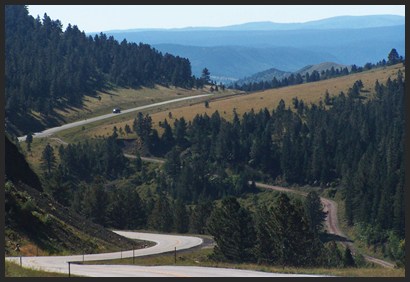
|
|
advertisement |
|
|
advertisement |