| |
| |
This is a modern highway,
crossing the historically most significant
divide in the American west. It was
discovered, lost and rediscovered. And then it
changed the history of westward migration. In
order to do that it has to be a small and
gentle crossing. People who seek out mountains
for the sake of being great mountains come
much later. You could even argue, that calling
it a mountain pass is stretching the meaning.
But actually, today's highway between Lander
and Farson has more elevation gain than many
other small summits in these pages, and it is
extremely bikable in my opinion, unless you
pick a windy day, of which there are a
majority here.
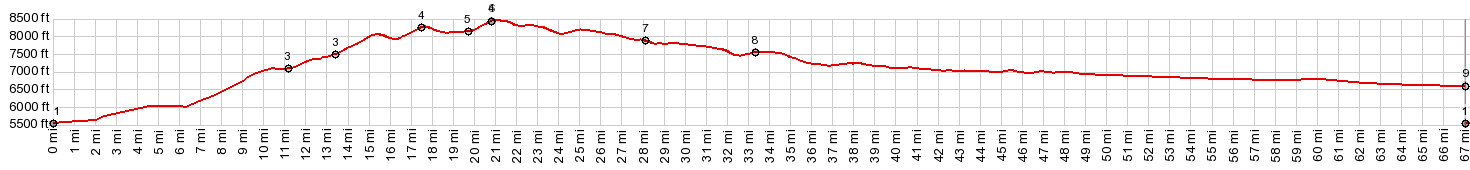
From East. The
profile starts about 19 miles after leaving
Farson. For some reason I found the shoulder
going up this side quite good and sufficiently
wide. But the other side of the road, going
down, seemed to be narrower in Lander county.
Once in Sweetwater county the situation
improves. The climb is still not noticeable, but
detectable on the profile. Right before it
becomes noticeably for the first time, a short
turnoff leads to a "South Pass overlook". Right
here at the bottom of something resembling an
incline, a series of about six panels outline
history from the Astorians to Fremont., and
point out the landmarks Oregon travelers used at
this point to orient themselves. It is
interesting to note that signs describe the
journey as going "through South Pass" rather
than over it - an implicit acknowledgment of how
gentle this crossing is, even more from this
side. From here on wagons would spread out
across the plain to find their own crossing,
presumably most of them lower than today's Wy28. From this direction also there are
several large waves in this ocean of sage to the
top. The highest point is easily missed. There
are no commemorations at that point, and why
should there be. Today's highway is different
than old mining and historical roads. These
spread out as rays of gravel roads, crossing the
paved ray with names like South Park City Rd,
Lander Cutoff, Lander - Piney stage road, the
Parting of the Ways with the Mormons" and
others.
Red Canyon Rd is a much quieter
ride. But I think the better views of all those
slanted reddish rock layers is actually from the
paved road. This part has a nice shoulder until
it is replaced by a climbing lane for cars.
Usually this works out fine. But cars will pass
cars regardless of how close a cyclist is,
trying to squeeze to the side. This part is also
often the windiest part of the climb.
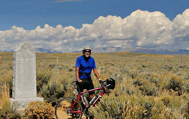
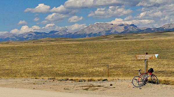
Just before the gravel road up Red Canyon rejoins Co28, the paved road takes a relaxation break too. From here on there is a good bikable shoulder again. It looks like it is only one more long sweep around a protruding cliff shaped like a long ship's hull, and the top is reached. But what looked like campers on top of the hill, turns out to be somebody's junk back yard. And it becomes apparent that that this large ruffled blanket of high sage has a still higher rumple ahead. 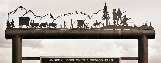 At the bottom of these two high rumples is a paved turnoff onto what my map calls Dickinson Ave. Signs call it Wy28. But then what is it turning off from. South Pass is also Wy28. Anyway, these ~5 miles detour around a mine tailings lake on the new Wy28 and are probably the nicest part of this pass ride. Countless gravel road opportunities exist towards the south and South Park City. Shortly after Scenic Wy28 rejoins regular old new Wy28, a last short straight climb into a dense forest signals the summit is near. It is actually located immediately after the Louis Lake Road turnoff. A large parking lot and a sign commemorating something different than the pass mark the spot. 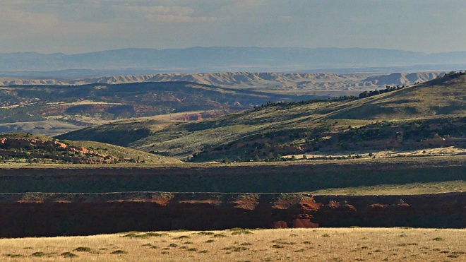 History The Fur Trapper Period: The first
thing worth pointing out may be something that
confused me for a long time before I bicycle
toured in this area. South Pass is not really
historically important because it is a
relatively gentle pass. It turned out to be so
consequential because at the time it was easy
to cross with the help of horses. These days
it's easiest to stay on I80 and never get out
of the car, as people hurry from one coast to
the other. For drink they stop at convenience
stores for a dose of sugar with chemicals.
During the Fur Trapper period you needed
water, and the dessert to the south of this
pass was a much more hostile environment, even
if it was devoid of mountains. It was a dry
dessert. So how did people stumble across
South Pass? The Astorians (<Teton Pass|>)
During the winter of 1812 the Astorian
explorers were in a demoralized state.
Congregated at their fort on the Columbia
river in Oregon territory, they had to head
back east to tell their fur company CEO the
sorry state of things. Hunt's 2000 mile
reconnaissance of the west over Powder
River Pass, Union Pass
and Teton Pass was
as useless for transporting fur back east as
the original detouring route of Lewis and
Clarke over Lemhi Pass, Lost Trail Pass
and Lolo Pass.
Also, a ship that had been used to reach their
company fort on the west coast, the Tonquin,
had been attacked and destroyed. In the end
four of the crew blew up the ship themselves
with attacking Indians still on board. During June 1812, four bearers of the bad
news, led by Robert Stuart left Fort Astoria
to convey the bad news to fur king Astor. On
their way back they would by accident, make
the most consequentlal pass discovery of the
Wild West period. Not really impressed by their own previous
course west, they met a Snake Indian, who had
previously guided the Astor group under Hunt
on their way west. Apparently there was a
shorter way to the south. Corroboration of
this rumor came later when they met three
trappers from the original Lewis and Clarke
group: Hoback, Robinson and Reznor who had
been roaming the west since then. With them
was also Joseph Miller, who was homesick for
Pennsylvania and agreed to guide them over old
Hoback-Robinson-Reznor territory. They made a
wide detour around their orginal Teton Pass,
as far south as the broad valley of the Bear
River in Utah. After having crossed Salt River Pass
they decended into Star Valley. In order to
find the Green River, as prescribed by their
guide, they crossed the highest most difficult
point yet, Sheep Pass at around 10 thousand
feet. However what they found on the other
side, turned out to be Greys River. And so
they decided to follow it down and take the
next best alternative into the mountains to
the north again. This was the wrong direction.
But the suspicion of Indian problems to the
south made them decide that this was
preferable. Along the way they passed today's
Palisade reservoir and the area around Jensen Pass.
They ended up crossing Teton Pass and "The
Rim" again, as they had on their expedition
west, in spite of their best intentions, They
arrived in today's Kendall, Wyoming after a
detour of 250 miles over 26 days. In the
following days Crow Indians stole their
horses, another member's sickness caused them
to wait five days, they suffered from hunger,
so that the proposal to eat each other was
floated (but rejected) and later on they
hunted a buffalo, part of which was eaten raw. All that just as a setup: Two days later
Snake Indians on Pocket Creek told them of a
shorter route to their intentions, and on
October21, 1812 they camped in a clump of
aspen, a few miles to the west of South Pass.
At this point it is worth pointing out, that
South Pass really refers to a line over
several miles on this gently flat bread mesa.
They could hardly discern a grade. They
estimated that the route lost 17feet to the
mile in the east, and 37 feet to the mile in
the west. The only mountains they could see
were the two buttes, Oregon Butte and
Continental Butte. These are also the most
impressive landmarks on a bike ride across
here. But the experience regarding the grade
is very different on a bicycle, which is four
miles to the north of their pioneering track,
and two miles south of the future historic
hiway, the Oregon Trail. Unfortunately in subsequent days they were
diverted much further south than 4 miles.
Their guiding river ended in the Sweetbater
Basin, as is their habbit in this fascinating
closed drainage. The group ended up in an area
known as Muddy Gap, between the Ferris and
Green Mountains. One hundred miles to the east
of South Pass they rediscovered their true
guding river, the Sweetwater.They followed it
to the North Platte, and wintered near today's
Torrington, Wyoming. Soon after April 1813,
Astor finally got the bad news. This coupled
with the fact that the War of 1812 with
England made the idea of supplying a fort on
the north west coast from New York a seemingly
impossible task. He allowed Fort Astoria to be
sold to the competing British North West
Company, operating out of Canada. Ashley's Rocky Mountain Fur Company. (<Granite Pass|>)
It was not until February 1824, some eleven
years later, that South Pass entered back into
the consciousness of fur company moguls,
because beaver hats were still in fashion. The
first two years of the company lead by William
Ashley, a Virginian who was lieutenant
governor of Missiouri, and whose knowledge of
beaver
trapping was confined to what was on his
head. These things were the affair of Major
Andrew Henry, who was instrumental in
exploring Reynolds Pass. Ashley's trappers had had problems with
Blackfeet and other Indians, that had cost the
lives of several trappers in the upper
Missouri Basin. Now two separate groups were
tasked exploring further south around South
Pass. Each of the groups was led by a person,
whose name is now attached to many famouns
landmarks, Jim Bridger and Jed Smith. Smith's
group approached the area via Granite Pass
in the Bighorn Mountains. After trying to
cross the other option in the Wind River
Mountains, Union Pass,
and then retreating because of snow, a group
of 11 ascended the Popo Agie beyond Lander and
crossed the pass again. They reached the mouth
of the Big Sandy into the Green River and
began trapping for beaver immediately. By 1825 General Ashley had taken a much more
hands-on approach to his western exploration.
He found himself in northern Colorado north of
Red Feather Lakes, heading north, later
crossing Rattlesnake Pass and Bridger Pass
on the way west. After that he crossed South
Pass for the first time himself. The days were
cold and difficult. But this only motivated
him to continue exploring towards the Uinta
mountains. By the late 1820s., three quarters of the
route of the Oregon trail was standard. In
1832 wagon wheels in quantity rolled over the
pass for the first time in the form Captain
Bonnevelle's twenty wagons.
Fremont (|>Monument Divide(Co):
Long after South Pass had become a
thoroughfare for trappers to their place of
work, in 1842, South Pass got its first formal
description by the topographical engineers for
the US government. This official inspection
took place. at the hands of Colonel Charles
Fremont. Fremont's decisive qualification for
the job was that fact that he was Senator
Charles Benton's son in law, who in turn was
the prime motivating power behind American
expansionism. Hoping to map, then settle the
west, which should lead to the conquering of
Spanish California, he sent Fremont west to
map the Oregon Trail. And so this pass became a central part of
westward migration. More than a thousand
people traverled over it during 1843. South Pass and its
surrounding Wind River Range country was the
prime destination of Fremont's first
expedition and he described its planar
characteristics for official consumption the
first time on August 8, 1842. The ascent was
so gradual, that "he found himself obliged
to watch very closely to find the place
where we had reached the culminating point".
He compared the climbing elevation to an
outing up captiol hill in Washington. "It is
difficult to fix the breadth of the pass" he
said after gazing across the plains.
Fremont's real interest was further south,
and so, with his father in law's permission,
during his second expedition he would try to
further the priciples of manifest destiny by
getting closer to the granite core of the
Rockies in Colorado.
 Dayride with this point as highest summit COMPLETELY PAVED: ( < FR300 Louis Lake Rd s(u) | Union Pass > ) South Pass x2:, Dickinson Ave(sh) upper jct Red Canyon Rd - Wy28 > Wy28 north > Dickinson Ave south west > Dickinson Ave(sh) <> out and back on Atlantic City Rd to turnaround point at 7920ft >> Dickinson Ave south west > Wy28 north > South Pass > Wy28 north << turnaround point ~19miles before Farson >> Wy28 south > South Pass > back to startingpoint at upper jct Red Canyon Rd - Wy28: 83.1miles with 5200ft of climbing in 6;48hrs (garmin ertrx 32x r4:23.09.10) Notes: contains minute amounts of non paved roads, but they are just short exploratory out and backs. But one of those out and backs towards South Park City made a point on Dickinson Ave a shoulder summit. 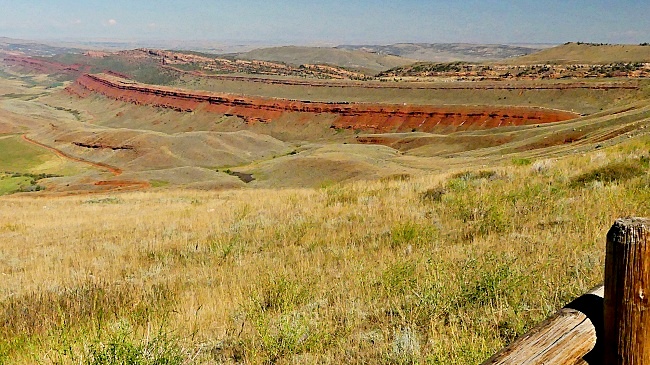 |
|
|
advertisement |
|
|
advertisement |