| |
| |
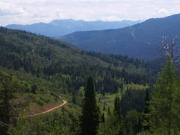
Jensen Pass
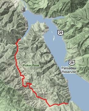
Palisades Reservoir in extreme
eastern Idaho is one of the few places, where
mostly freely accessible national forest land
surrounds a large damned reservoir. The area is
crowded with not only national forest campgrounds,
but also open land, that can be used for less
formal camping. The area abounds with ATVs and
noise on holiday weekends. But there is also a
named pass in the area, that at least during
July/2010 was closed to motorized traffic and
perfect for a mountain bike ride.
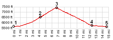
From North. The description begins
at the junction with paved US26. The profile above
starts later. North of Palisades Reservoir a paved
road crosses the damn. A forest road climbs on
gravel surface to a junction with another dirt
road leading back down to the Snake River. Staying
left at this fork leads to a traverse above the
lake and finally back down to it, to a second
National Forest campground. The route up Jensen
Creek stays left where the Bear Creek
road/trailhead goes right. Finally we leave the
busy reservoir behind us. But in July even all the
undeveloped campsites along Jensen Creek are
filled with little circled wagon camps of trailer
residents. At the next junction a sign points left
"3 miles to Jensen Pass". A little later a
barricade closes the road to motorized traffic. A
good, easily bikable dirt road, devoid of the
gravel that has plagued the ride sofar, traverses
up above the east side of Jensen Creek and aims
for an obvious gap straight ahead. There are one
or two views down the valley, but the gap does not
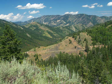
go above treeline. From South. (described downwards). Views
are limited, but the mountains ahead belong to the
Snake River Range on the other side of Snake
River. There is one nice, shady campsite a short
distance below the summit. Gravel returns on the
lower part of the descent, before the road crosses
the "closed barrier" on this side. Turning left
along McCoy Creek leads back down to the reservoir
and the profile ends here. However to get back to
US26 a few more small hills along the reservoir
need to be completed.
Dayride PARTIALLY PAVED / UNPAVED ROADScampsite along Indian Creek, a short distance east of US26 off Palisades Reservoir > US26 nw > FR58 sw > Jensen Pass > down McCoy Creek > Alpine > starting point: 54 miles with 4000ft of climbing in 4:4hours. (VDO MC1.0 m3:10/8/1). |
 Approaches
|
|
advertisement |
|
|
advertisement |