| |
| |
Lemhi Pass
The story of Lewis and Clark and
their Indian guide Sacajawea is one of America's
favorite old west exploration stories. And since
this was an official expedition, record keeping
was excellent - as opposed to some of the private
trapper explorations of John Colter, who may have
been chased down the Yellowstone naked by Indians,
but nobody knows exactly where. But we know what
Captain Lewis wrote and said, where they camped,
and other stories, such as giving birth along the
way. Lemhi Pass is where Lewis and Clarke ended up
crossing the continental divide, and the result is
an official US landmark pass, which makes a great
bike ride.
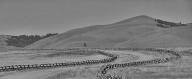
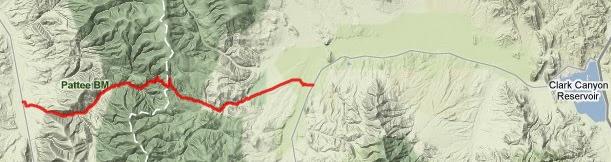 Approaches From East. The approach form this side is
much lower than the western side and the road is
in better condition. The turnoff to Lemhi Pass
road is located at a series of low hills named
Shoshone Ridge, and is well signed. On Shoshone
Ridge a few tablets outline the history of the
pass. The pass road starts out in high flat
sagebrush and grazing country, a wide, hard
medalled path, bordered on the sides by private
land as indicated by wood barrier fences, rather
than the more ordinary picket wire fences. After a
short distance the road enters the hills and meets
Horse Prarie Creek. This would have been a great
space to camp, but apparently they went a few
miles further upstream on that day in August. The
road continues to climb gently through widely
spaced farms. The grade increases where the road
enters the national landmark. It's the first time
that the climb becomes really noticeable on a
bicycle. But it levels out again after the single
switchback to the summit. To the south there is a
1/4 mile spur to a peaceful group of picnic
tables, named the Sacajawea memorial area. Two
tablets state that there are many interesting
stories concerning Sacajawea, and then goes on the
tell the story of the woman whose wish it was to
establish the memorial, not mentioning
"Sacajawea's interesting stories" again.
From West. (described
downwards). There are actually two approaches. The
longer one leads over a higher elevation to meet
Id28 further north. The approach described here
descends directly to Id28 at Tendoy. Looking down
the steep grade, canyons and peaks behind lower,
green ridges, this looks like a formidable pass,
and one can empathize with Lewis's original words,
that are now used to start the National Landmark
pamphlet: "we proceeded on the dividing ridged
from which I discovered ranges of high mountains
still to the west of us...". But on this ride we
don't have to cross them and the way down is
pretty fast. The road over here is rougher, much
steeper and the top is very washboard like. As the
grade levels out conditions improve. Two more
signs pinpoint a Lewis campsite and also a stage
coach stop. Tendoy has one store with potato
chips, tiny little cans of wieners, soda and
things like that.
Tours Dayrides. BLM road not far from Shoshone Ridge > up east
side of Lemhi Pass > Tendoy > south to
Leadore > Bannock Pass > back to starting
point measured: 82 miles with 4500ft of climbing
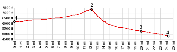
in 6:1hours (VDO MC1.0 m3:10.8.24).
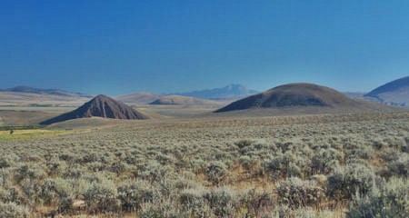
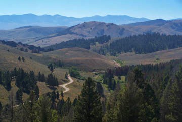
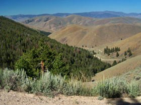
top: early morning view from
Shoshone Ridge down valley; middle left: looking
east (Montana) from pass; middle right: looking
west (Idaho) from past; bottom (right): wide road
on lower east side History Lewis and Clarke: (<Pipestone Pass|Lost Trail Pass>) In 1803 something so stunningly unexpected happened, that it would sound too contrived for a novel, if it had not actually happened. Napoleon sold, what was at that time called Louisiana, to president Jefferson for 15 million dollars, effectively doubling the size of the United States on paper. Already before the Louisiana Purchase Jefferson had shown interest in exploring for the mouth of the Columbia, and had laid plans for such an expedition. He assumed that there was a close connection between the Columbia and Missouri river systems. Captain Lewis also guessed that the Missourri started at a low pass in the northern Rockies, using data from MacKenzie's Pacific journal and Indian hearsay. Without this assumption this story would have developed completely differently. The planned route was up the "just yesterday French owned" Missouri to the English coveted North West. They left from (town of) Missouri May 1804 and took one full year to travel the known extend of the Louisiana Purchase to today's area of Bismark, North Dakota. Rumors in the spring of 1805 that British trappers of the North West company were also heading for the Pacific lead new urgency to their plans that spring. Lewis and Clarke continued by boat up the Missouri and saw the mountains first at the mouth of Marias River, named for Clarke's love interest. The mountains were still 100 miles away. This actually would have been a good route to the Columbia, as the Great Northern Railroad showed a century later by laying rails over Marias Pass, but Lewis and Clarke decided to follow the Missouri further upstream. This lead them south. However one thing became clear at the sight of these great mountains. This was not just a boat journey with a short portage. The first portage around Great Falls, Montana drove the point home. They needed horses to pack eight boat loads of stuff. And so all the preparation, study of astronomy and navigation took a back seat to an unexpected turn in the story. Along in Lewis and Clarke's party was not only John Colter - who would become the legendary explorer and teller of tall tales returning from Yellowstone Park, naked chased by Indians - not only Toussannt Charbonneau, aging French Canadian interpreter with the Indians, but also his de facto teenage wife - boat woman. Today signs along western highways refer to her as Sacajawea. She was a Snake Indian who had been captured by Minitaree Indians, eventually selling her to the French Canadian Interpreter. The and most important fact about her in this story is that her tribe owned horses, desired by Lewis and Clarke for the upcoming portage.. And so one of the most popular stories of exploration of the American west begins. July 22nd was a happy day. The expediton camped near Three Forks, and Sacajawea announced she knew exactly where they were. She recognized the place where she had been captured by Minitarrees in 1799. On August 8th the news was even better. The Indian girl saw a landmark closer to her home, Beaverhead Rock - another Lewis and Clarke trail waymarker today. Looking west the horizon was and is dominated by the Pioneer Mountains. But kindly enough, they do not reach very far south, and beyond them are several gaps in the ever so gently rising horizon. One of them is Lemhi Pass. Lewis scouted ahead with three men. It took three days to reach this gentle gap and during that time they observed an Indian fleeing on a horse - a promising sign. Lewis succeeded in making friend with the Snake Chief Cameahwait, who also was boat woman's brother. After two weeks of deal making and social business, Lewis crossed back over Lemhi Pass with horses and accompanying Snake warriors. The Lewis and Clarke party united and again crossed Lemhi Pass a third time, to the Snake River, after having cached all the boats near the mouth of Horse Prarie Creek. The journal notes that a lagging Indian helper gave birth during the descend on the western side of the pass. Even though the Salmon flows generally in the
right direction, north and west, further
examination of the topography and the Salmon
rapids convinced them that the best way forward
was north and back over the Bitterroot Mountains
again, in the direction of Marias River. The next
pass they crossed and is also named is Lost Trail
Pass. Montana Gold Rush (<Bannack
Pass|Badger Pass>) Lemhi Pass along with
Bannack Pass were used by gold seekers who
approached the town of Bannack from the west. |
 Picture Locations:
|
|
advertisement |
|
|
advertisement |