| |
| |
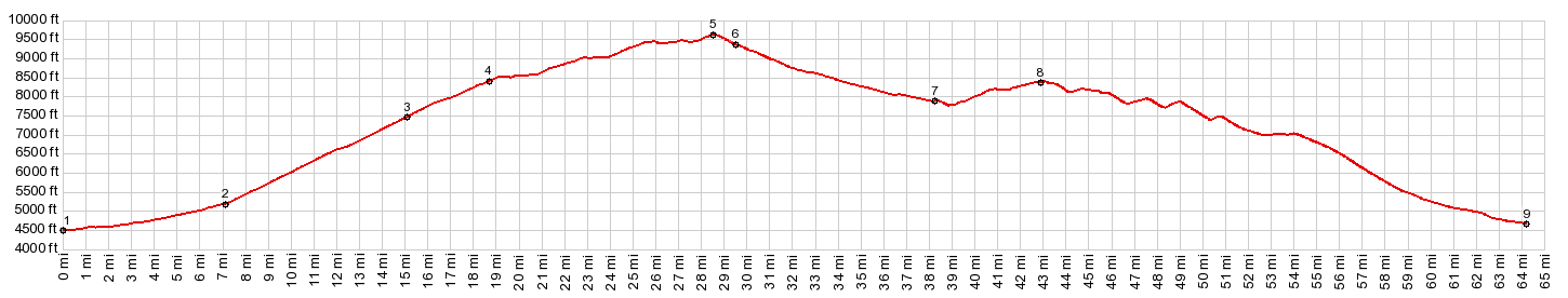
Powder River Pass
Powder River Pass is one of two
great scenic routes across the Bighorn Mountains,
which are mostly located in north Central Wyoming.
But they reach up into Montana. This pass has a
big elevation gain, but the road never becomes
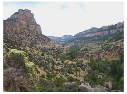
very steep. Scenically the most intersting part is
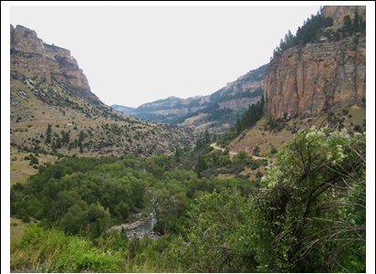
the canyon topography on the west side. The only
time there seems to be a lot of traffic is when
the nation's motorcyclists are converging on some
little town in North Dakota for a kind of american
motorcycle holliday.
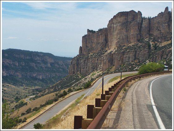
There is an excellent shoulder on the entire length of this road. I seem to remember a few miles of rumble strips on the lower west side. But they are very narrow, and to the right much space remains for a safe ride.
The first geological sign informs that we are now
cylcling, surrounded by cliffs of the Tensleep
Formation, a yellowish rock, with a few old homes
at its feet. Next comes the Madison Formation. The
canyon begins to widen out and a forest becomes
visible above the canyon.
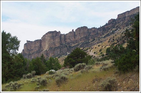
Next comes the geologic star in this road show
the Ordovician Bighorn Dolomite. Dolomite always
knows how to put on a grat dramatic show in a
mountain setting. It's a cliff former because it
is relatively water soluble, and Two distinct
members of this dolomite form straight cliffs,
still sloping upwards like you expect this big
roof to do. The road requires a handful of
switchbacks to get to a level above this dolomite,
and all of them are climbing between lips of this
rock, as they should. This Ordovician dolomite
smells funny too. - Oh wait - no, those are the
break pads of the trucks coming down. Apparently
there is more climbing ahead. By the the time the Cambrian Galatin formatin is
reached, the show is largely over. The road goes
straight in dense forest. But there is one more
unusual sight - a ski resort, well a ski area with
a single lodge. At the base is a large lake, a
reservoir constructed by the CCC - a very peaceful
setting for a ski resort, maybe with apres ski
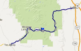
skating. All along the way various dirt roads beg for
further exploration. So far I only know Canyon
Creek Road,which connects to the CR3 Hazelton Road
summit point. Slowly the subdued summit ridge has
been coming into sight. Once the top becomes
visible the work is over. The road levels out,
makes two more elegant right angle turns to reach
the rocky gap at the summit, and then even dips a
little bit, as if to encourage momentum to sling
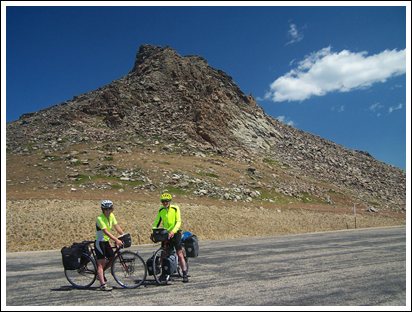
shot to the top. This summit ridge is shaped like
something that has risen through baking, but it is
pure rocks, no range land, and standing beneath it
at the summit, you could even call it a cliff. On
top is a monumental parking area - and yes a sign
too with official elevation 9955t. All the parking
areas along this road have been built, so that
nobody will ever have to park in the vicinity of
anybody else even on Memorial Day weekend,
although some people do this anyway. There is one
more geological kicker at the top: "precambrian
gneiss: 3 to 3.8 billion years old" reads the sign
under a mountain pile of practically
indestructible rocks, a multiple of times older
than the last time rocks were exposed next to the
road. From East. (described
downards) To the same degree that the west side
has remarkable canyon scenery, this side does not.
Rolling away from the rocky top, the ride becomes
a pedal as fast as you can down the gentle
forested slope thing. Going down on this side
requires another 580ft climb to an unofficial
point, for which I have a separate page: the Powder
River Road eastern summit s(u). More of the
approach on that page.
Dayrides with this point as highest summit: PARTIALLY PAVED / UNPAVED: ( < same page | Powder
River Pass eastern summit s(u) > ) PARTIALLY PAVED / UNPAVED / INDISTINCT TRACKS ( <
CR67 Slip Road northern summit s(u) | same
page > )
A Day on a week long Tour, with this point as
highest summit: ( < | Granite
Pass > ) History The Fur Trapper Period: The Astorians ( |
Cottonwood Pass> ): In 1807, after their
expedition to the north west coast, Merriweather
Lewis wrote President Jefferson about the great
potential for fur trade in the west, and also
advocated an outpost on the Columbia River to
represent US presence. Jefferson encouraged John
Jacob Astor, German born New York fur king with
dreams to control the fur trade all over the world
to establsh this outpost. This was the very beginning of the fur trade age
in the west. Sofar the North West fur company from
Montreal hat established three outposts in the
west of Canada, and the Spaniard Manuel Lisa
was about to establish a fur trading outpost near
Yellowstone for his Missouri Fur Company. In 1811 John Jacob Astor joined the list of treks west in full force. His pack trail of 65 people, lead by William Price Hunit, was the largest the west had seen since the days of de Anza heading for California. Their initial objective was to follow the Lewis and Clark route to Lemhi Pass. But in August they met three hunters, who had been employed by the Missouri Fur Company and who had the explored parts of Wyoming and Montana with the likes of story tellers like John Colter and other trappers. This changed their plans completely. Unlike the Lewis and Clark expedition, from now on the Rocky Mountains would be explored Spanish style, primarily on horse back, and not by boat. After trading with Crow Indians they ended up with 82 of these creatures.
And so Powder River Pass became the first Rocky
Mountain Pass to be crossed by the Astorians.
After horse trading with the Crows was done they
followed an old Indian trail which roughly
followed today's US16 to Powder River Pass. The
name of Tensleep Creek originates from being ten
sleeps away from the Absoraka villages in the
Yellowstone area. The group followed the trail
through the badlands at the western foot of these
mountains to the area of Worland. From there they
avoided them by detouring south over Cottonwood
Pass and Sioux Pass to today's Lysite. Ashley's Rocky Mountain Fur Company: ( | Granite
Pass > )Roughly one decade later, things had
not changed as much as one might suspect. Now
there was a new "fur company", William Ashley's
Rocky Mountain Fur Company. The frist two years
had gone very badly. In 1822 Ashley's goal was to
not go into the upper Missouri area, where
trappers had found more Indians wanting to kill
them than beavers to kill. Instead he wanted to go
with his trappers into the Green River area. His
group of trappers was much smaller than the
Astorians in the previous decade, but the leader
was the same: William Price Hunt, originally from
New Jersey. So how would they get there. Hunt's original
route west, connecting Powder River Pass, Union
Pass and Teton Pass was not very useful for their
purposes. But during the return trip, a few
Astorians, notably Robert Stuart returned from
Oregon and accidentally made the biggest discovery
of the entire journey: South Pass, a way across
the Rockies that is really not a pass but a plain.
The grade is less than 30ft per mile on each side. In late August, after Ashley nearly went
bankrupt, they found themselves at the confluence
of the Powder and Yellowstone Rivers. Ashley spit
up his already small group. He and several others
went north to look for Green River and South Pass,
while William Price Hunt again entered the Rockies
via his old route, Powder River Pass. Most of the
select group people who accompanied him, would
become famous guides and fur traders: including
James Bridger, Thomas Fitzpatrick and William
Sublette. After coming down Tensleep Canyon, this
time they crossed the Powder River badlands,
instead of detouring to the south. This lead them
to the Thermopolis area where they used one of the
passes that detoured around Wind River Canyon Separate from the Hunt group, but also part of
the Ashley company was another handful of men, led
by Jed Smith. They entered the Bighorns over
Granite Pass
|
|
|
advertisement |
|
|
advertisement |