| |
| |
Louis Lake Rd s(u)
This gravel road loop through the
foothills of the Wind River Range is popular with
all kinds of travelers: drivers, ATVers, I even
say 5 gravel bikers. They were busy getting ready
for a race tomorrow, that includes this road. The beauty in this loop lies in its
carefreeness. It is not so empty that you have to
worry dying of exposure if anything bad happens.
Yet it is not so busy, that traffic is a problem.
The scenery is pleasant and peaceful forest. There
are also a few moments of uniquely Wyoming scenery
on the north side.
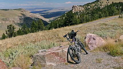
So now we are turning off Wy28 onto
Louis Lake Road. A walk in campground at the
junction seems to be closed. Instead there is a
large parking lot. The first several miles of this
road are very busy with campers and hunters and
ATVs. Then traffic thins out slowly. These high
elevation needle forests, separated by expansive
meadows and craggy outcrops parade by the side of
the road, and this is also a great escape from the
heat. The road just seems to roll along, slowly
gaining a 100ft or so in each step to the next
meadow. At the first large lake, there is an
official national forest resort of old huts, in
close proximity of a lake shimmering dark blue. I
keep wondering when that monumental downhill will
start back down to Lander, but there still is
quite a distance to roll along. When the road
crosses the Popo Agie River it is just a peaceful
creek through the woods up here. Hard to believe,
that yesterday, just a few miles further west, it
carves the canyon that was the subject of the
rugged slow journey on wheels and foot the day
before. 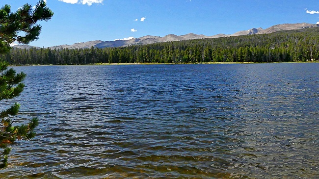
When I reach Fiddler Lake I cannot
wait any longer with lunch, because this is the
perfect spot. It is not so much spectacular as it
is peaceful, with that subdued distant lip of high
mountains behind that dark blue wavy surface. Best
lunch spot imaginable for today, with the high
peaks so far away there is no reasonable chance
for an additional out and back to to reach them
today. Just sit by the lake and enjoy the cool
sunshine. This is also fairly close to the
summit point on the road - just one more lazy
curve to the top. The top is a broad but well
defined saddle in the trees. A sign labels the
elevation (9574ft?), and calls the spot the Blue
Mountain Historic Trail.
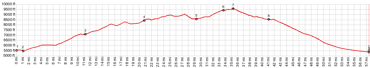
Dayride with this point as
highest summit
PARTIALLY PAVED / UNPAVED ( < Limestone Rd s(u) | South Pass > ) Louis Lake Rd s(u) : jct Wy28 - upper Red Canyon Rd > up Wy28 > south on FR300 Louis Lake Rd > Louis Lake Rd s(u) > Lander with short shopping detour > US287 south > Wy28 south back to starting point at jct Wy28 - upper Red Canyon Rd: 67.6miles with 5900ft of climbing in 6:36 hrs (garmin etrex32x m5:23.09.08). Notes: the time is a close approximation. Battery ran out during last 45 minutes of ride. But I reconstructed it with the identical part of the route from yesterday ( < ... | Union Pass > ) same summit point: near jct FR300 Louis Lake Rd > south on FR300 Louis Lake Rd > Louis Lake Rd s(u) > Lander with detour > US287 south > Wy28 south back to jct with Louis Lake Rd: 73.4m with 5780ft of climbing in 5:55hrs (avocet50 or cateye cycle computer: m2:96.9.3) (pics t96_2-42) Notes: basically the same loop as above from a higher starting point and more short exploratory out and backs |
|
|
advertisement |
|
|
advertisement |