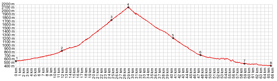
| |
| |
Col du Tourmalet No other pass is more strongly
associated with the Tour de France than the Col
du Tourmalet. The cycling traffic on the pass
can be pretty intense during 3 out of 4 seasons.
During my tour I was especially impressed by the
average age of the bikers that I saw on this
pass. It gives me some hope for the future. But
even these riders probably weren't around for
the first race over the top in 1910. Col du Tourmalet is the highest
French paved pass in the Pyrenees. Only one
Pyrenean paved pass is higher, the Port
d'Envalira in Andorra, not nearly as interesting
a bike ride. The name Tourmalet means something
like "bad road or way".
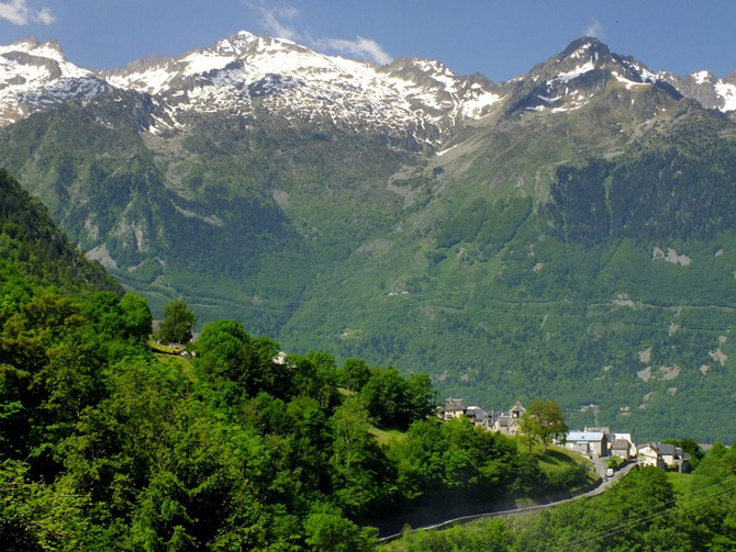
This is the more pastoral, less developed lower
approach, with much fewer towns than on the other
side. There are no shoulders on this medium width
road, and there is some traffic, and never have I
seen outnumber cyclists any other form of traffic
on the road, including farm tractors, by such a
wide margin. As the road begins to climb above the valley
floor, it passes above a campground and a small
group of big brick buildings, grouped around a
small power plant. Everything has a pleasantly old
appearance. In the nearby Gite I also ask for
accommodations, just for future reference. The
apron clad host, surrounded by pots with all kinds
of odoriferous eatibes, takes a few minutes away
from his kitchen activities to check in his foot
high hand written ledger book. It looks like next
Wednesday there is an opening for a bed and full
board for 80 Euros a night. My BNB reservation at
La Mongie near the top of the pass is clearly a
better deal, as far as I am concerned. The road now starts to climb in earnest, leaves
the villages below and provides views of them from
far above, during a Z shaped detour in deep
forest. One of several long descriptive signs next
to the road tells anecdotes of the Tour de France.
I stop to photograph it, so that I can catch up on
this when I have more air to breathe, but
unfortunately I will never see the photos. Above
the quiet Z in the misty forest, the road emerges
above treeline. During my first arrival, the mountains are
shrouded in deep fog, but still show up as a
gentle outline in a quiet dense grey soup.
Approaching the ski infrastructure, the road goes
through several galleries. The ski condo
skyscrapers of La Mongie appear like an unexpected
ghost city with a futuristic look. But still the
10 story and higher buildings are dwarfed by the
mountain walls on each side. This will be my home for the next five days - a
place to start rides with a long roll down from
the top and finish with a big climb - a place to
watch llamas climb at eye level on the opposing
ski slope, so close they seem almost touchable.
But there is a wrench in my La Mongie skyscraper
ghost town paradise. All the stores are closed,
including the fairly large and in winter well
stocked supermarche. I buy a few raw materials
from a kindly resteranteur, so that I can prepare
my own food and drink in my rented ski condo. But
first the caretaker has to turn on the electricity
in my room. 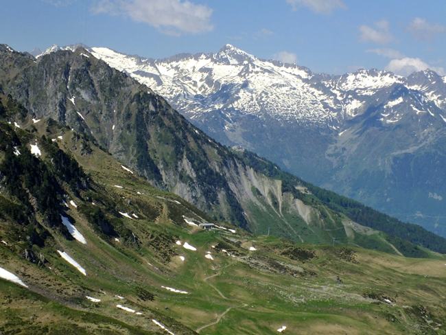 The first ride to the top of Col du Tourmalet
takes place in perfect early morning light. Llama
heards fill the skyscraper driveways. When I come
back and it starts to rain, the same animals
huddle under a driveway bridge - so close
together, there wouldn't be any more room for me
to escape from the rain. But now it is still
morning, and the best part of Tourmalet lies
ahead, the last few hundred meters of climbing to
the summit. It is far from a wilderness, with all
that ski infrastructure, but it is an amazing
environment all the same. To the south Pic d'Espade (2467m) presents a
wall. But the real landmark peak, immediately
recognizable from the plains below, Peak Du Midi
de Bigorre (2877m), lies on the north side. Two
separate dirt roads leave from the pass towards
the summit of Pic du Midi and its observatory.
They also lead to several mountain bikable passes,
and I can see at least one tunnel ahed. But on
this May day there is still too much snow to get
very far in a reasonable amount of time, and so I
turn around. At the top of the pass stands another Tour de
France inspired monument, a climbing cyclist with
an interesting expression on his face, as he gazes
skywards at the apparently extremely difficult to
reach summit. Unlike other cyclist statues that I
have seen on other passes in Europe, this
sculpture seems to express a joy for this
exasperation, under that old sheppard hat, or
whatever it is he is wearing, - not just utter
exhaustion that needs to be medicated with drugs.
Again, tourists arrive by the busloads to have
their pictures take in front of this interesting
motive. It was installed in 1999 and since then
must have made it onto millions of photographs and
100s of web pages, including this one. A close by,
much less photographed statue of Tour organizer
Jaques Goddett is easily overlooked. It makes it
into far fewer personal pages, but instead into
the wiki pages of this summit. During one of my rides I meet a couple sunbathing
in front of their camping bus at the summit, two
bicycles mounted on the back rack, always a good
sign. I strike up a conversation and learn that
they are avid touring cyclists and had in the past
toured around the world for several years. During
their last trip in south east Asia their camera
was stolen and they have no pictures. During the
time I don't know yet that I was going to have the
same happen to me on this trip. For this pass I
managed to salvage a small percentage of the
pictures from an overwritten memory card. We spend
the afternoon riding together down the west side
and up towards Gavarnie 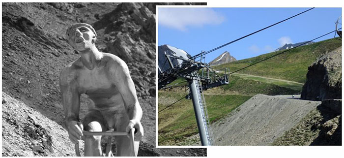
Lourdes has the best variety of accommodations
below this pass for my money, but Argeles-Gazost
is the more popular basecamp town, since it is
closer to yet more famous cycling passes to its
west. Here I take some pictures of cycling mail
carriers around town. Unfortunately that pictures
did not survive. Where the bike path ends, and starting the
profile, near Soulom, is the only section, which
could actually be a little unpleasant for some
riders. The road has heavy traffic and leads
through the narrow Gorge de Luz, to a "mountain
park" (in western US landscape nomenclature), in
wich lies Luz St Saveur Le Coumet. This is the
major tourist town at the foot of the mountains on
this side, surrounded by magnificent peaks in
every direction, tourists milling through the
streets looking for souvenirs, and cyclists
arriving by the busload. Still - all the grocery
stores close by 1pm and remain closed until after
I would suffer from a major caloric deficiency
while trying to bet back to the top, But I
persuade one shop owner to let me run through his
store to gather up a baguette, large amount of
brie, tomatoes and cookies before he locks the
door. From here the road turns eastwards, and stays at
the bottom of a steep valley. The mountain stream
Le Bastan has been crammed into a wide, straight
and rocky, elaborately engineered stream channel,
so that all the towns and skiing infrastructure
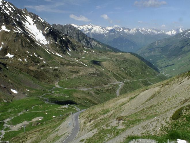
also find room on the valley floor. Approaching the ski area Le Bastan the road seems
to traverse a large ski area parking lot. This
marks a transition point. Above seemingly
unreachable, but large well built mountain farm
houses seem to be glued to the hillside. The road
itself climbs above treeline with a few initial
steep meanders and then carves its way around the
amphitheater, still far below Pic de Midi. This
peak together with the transmission facility at
its top makes the visual focal point on this side.
Above the gap to be reached, is clearly visible,
often surrounded by herds of llamas and cut into
visual wedges by ski lift wires. PARTIALLY PAVED / UNPAVED: ( < Col de Beyrede | Hourquette d'Anzican > ) Col du Tourmalet x2, additional out and back: La Mongie <> Col du Tourmalet <> separate out and back towards Pic du Midi but turnaround due to too much snow left <> Bareges <> Luz St Saveur de Le Coumet <> a few km up towards Gavarnie as as far as Cautarets with turnaround due to deteriorating weather (r5:16.4,5) Notes: gps data is on stolen computer. Pictures are my own. A Day on a Tour with this point as highest summit: COMPLETELY PAVED: ( < Hourquette d'Anzican | Col d'Aubisque > ) Col du Tourmalet: La Mongie > Col du Tourmalet > Bareges > Luz St Saveer de Le Coumet > Pierrefitte-Nestalas > Argeles-Gazost > bike path to Lourdes with scenic detours: (r5:16.4,5). History Early roads: One of the earliest times, that history mentions this pass is in 1088, when nobility left one side to collect taxes on the other - what a way to enter history. But actually, shepards and pilgrims have used the pass for an unspecified time before then. The first road was planned in 1688 and finished in 1730. The next period during, which the pass road was improved, was the road building period under Napoleon. The "Route Thermal" was inaugurated with a ceremony at the pass itself in 1859. The name alludes to crossing the pass in order to get to the thermal curing waters of Bareges at point 5. This route basically lasted into the 1970s, when a more modern road bed was constructed. 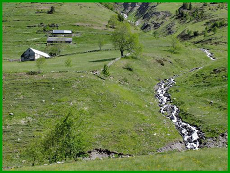 Tour de
France: In 1910 the Tour de France for the
first time, crossed a pass in the Pyrenees, and they
picked the highest one first. But the pass was
already of interest to cyclists before then. The
"Touring Club de France" mentioned it in already in
1902. The statue of the climbing cyclist at the top
commemorates the first Tour de France leader over
the top, Octave Lapize. Tour de
France: In 1910 the Tour de France for the
first time, crossed a pass in the Pyrenees, and they
picked the highest one first. But the pass was
already of interest to cyclists before then. The
"Touring Club de France" mentioned it in already in
1902. The statue of the climbing cyclist at the top
commemorates the first Tour de France leader over
the top, Octave Lapize. This first crossing remains a monumental endurance event state. It was 325km long and also climbed Col de Peyresourde, Col d'Aspin, Col d'Aubisque and Col d'Osquich. That year an even longer but infinitely flatter stage went 424km from Brest to Caen. But combining Tourmalet with Aspin and Aubisque has become the classic race route, emulated by thousands of cycling tourists every year. Three years after the first Tour de France crossing, the racer Eugene Cristophe broke his fork coming down the east side of Tourmalet. It happened about 10km before reaching Saint Marie. He came into the little village, carrying his bike. A welder offered to do the repairs. But race officials insisted that riders were responsible for their own repairs, and so he managed to weld the fork himself with some guidance. He received another small time penalty for receiving help from a kid with the bellow inflating the tire. Eugene Cristophe still managed to finish the Tour in seventh place. With a story like that, the pass is bound to become famous. Since 1910 the pass has been included in the Tour de France route more than any other pass, and that adds up to 83 stages up to 2014. This includes a few finishes at La Mongie, and a stage ending at the top. The Vuelta de Espana has also crossed the pass several times. 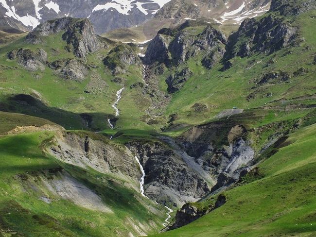
|
 In this town I see two expensive
little inns, that cater to cyclists and their
pension for quiet little places to rest
comfortably and eat well, and as much as humanly
possible. Leaving Saint Marie de Campan, the
simple but attractive old houses seem to line up
in rows perpendicular to the main road, like rows
in a theater, where the stage are the mountains to
the south. At the back of the stage looms the Pic
du Midi de Bigorre, and below it is the Col du
Tourmalet.
In this town I see two expensive
little inns, that cater to cyclists and their
pension for quiet little places to rest
comfortably and eat well, and as much as humanly
possible. Leaving Saint Marie de Campan, the
simple but attractive old houses seem to line up
in rows perpendicular to the main road, like rows
in a theater, where the stage are the mountains to
the south. At the back of the stage looms the Pic
du Midi de Bigorre, and below it is the Col du
Tourmalet.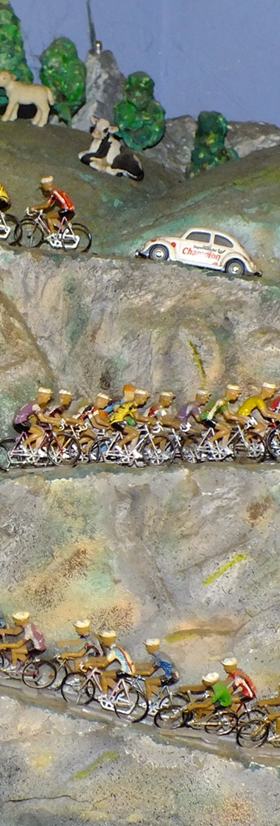 From West. (also described
upwards). This side has many more towns, a much
wider variety of accommodations and
correspondingly more traffic. The approach below
the shown profile, starting in Lourdes follows a
rather fantastic, smoothly paved bike trail, an
old rail line entirely separate from any road. The
picture of the diorama excerpt of a race caravan
going up Tourmalet was take in a gite along this
bikepath.
From West. (also described
upwards). This side has many more towns, a much
wider variety of accommodations and
correspondingly more traffic. The approach below
the shown profile, starting in Lourdes follows a
rather fantastic, smoothly paved bike trail, an
old rail line entirely separate from any road. The
picture of the diorama excerpt of a race caravan
going up Tourmalet was take in a gite along this
bikepath.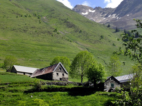
|
|
advertisement |
|
|
advertisement |