| |
| |
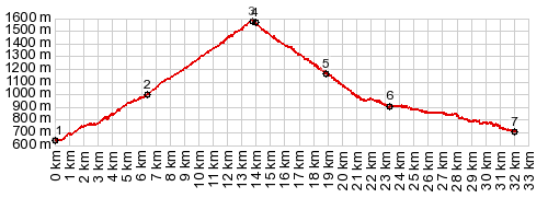
Col de Peyresourde
The Tour de France has crossed
Pyrenean passes east of here. But none of those
have been crossed nearly as often as this one.
Partly this is due to the geography of roads. To
get from the more easterly Pyrenees to the Central
Pyrenees with its high passes Col du Tourmalet
and Col d'Aubisque,
you have to cross this pass. Its numerous Tour de
France appearances are partly a geographical
necessity. From a scenic standpoint - what stands
out in my mind about this pass are the sweeping
grass hills near the summit on the west side, and
the scene along these few kilometers also makes up
95 percent of the pictures taken.
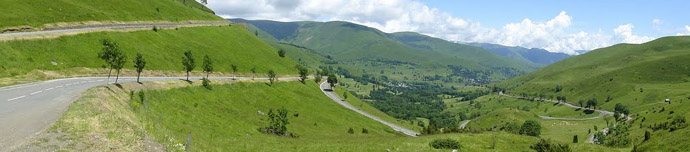
The start of this climb has more traffic and less
shoulder than I had been spoiled with in recent
weeks. The road traverses up a south facing ridge
and passes by the villages at a distance, that
makes them look panoramic. In order to go through
one villages, you turn off at a curious triangular
building, that wedges between D618 and the
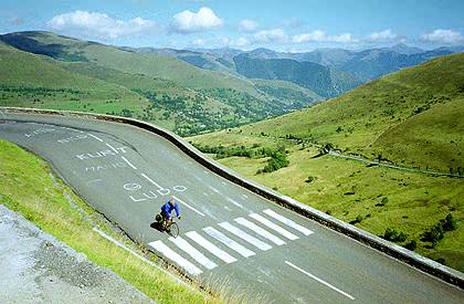
hillside. The image that seems to be most associated with
this pass (definitely the most photographed) comes
further up. It is the long straight away and
following meandering switchbacks on sweeping grass
hills. In my memory I would have judged the reach
of these back and forth meanders below the summit
much larger, than they actually appear on the map.
They do tend to stick in my memory larger than
they actually are. Across this green bowl lies
Portet-de-Luchon, its houses displayed like models
in a green porcelain dish. Again the signed main
route passes by the village so that it appears to
invite to be explored, without actually showing
off its workings. A side road leads through the
village, and I have been told that this is
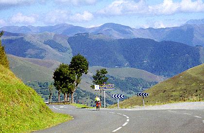
actually a preferable biking route. Traffic up here above the trees is much lighter
and consists largely of cyclists of all types. I
even see a few other tourists with heavy saddle
bags. In my case the light is pretty hazy here.
From West. (described
downwards) At the top waits a small transmission
facility and I seem to remember a Tour de France
sign and a small building. Also - the light
conditions improve and suddenly make the far Pic
du Midi de Bigorre stand out of the landscape like
a crown. An at least equally impressive
photograph, but with totally different lighting of
the exact same scene is in the slideshow. Immediately after the summit an additional loop
can be used to substitute a higher point as
summit. for the Col de Peyresroude, This loop
leads to a ski area and then rejoins the profile
further down. I only ride up the first km and
conclude, that from that loop the view onto high
peaks is much more expansive. The profile descends below treeline and the peaks to the south seem to grow in stature. A few last verdant pastures make a radiant foreground to big white wedges behind, as I roll into Loudervielle. The now busier road collects a number of small villages before it gets to Arreau. They all have an appealing outside. But none of them have open grocery stores or hotels. Arreau hotels turn out to be also extremely expensive or closed in June, and the Tourist Office personnel seem to take pleasure in telling you this. I actually ride the lower part of the profile several times in order to check this out myself, and finally retreat down the valley in heavier traffic to Sarroncolin, which is not much better.
History Cycling-Tour de France: Between 1948 and 2016, the Tour de France crossed the pass in a full 45 years. Imagine all the types of bicycles that have crossed this pass. In 2012 it was even climbed twice. One of these times the climb continued to the ski area mentioned above. A Day on a Tour with this point as highest summit: COMPLETELY PAVED: ( < Port de Bonaiqua | Col du Beyrede > ) Col de Peyresroude , Col du Portillon : Vielha > Bossost >Col du Portillon > Saint-Mamet > Bagneres-de-Luchon with sighseeing detour > Col du Portillon > Loudervielle > Arreau <> several out and backs with detours back up valley looking for a place to stay >> Sarrancolin Notes: a long day, distances and gps data are on stolen computer
|
|
|
advertisement |
|
|
advertisement |