| |
| |
Col d'Aubisque
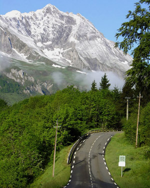
For me Col d'Aubisque is scenically
the most interesting and unique pass, that I have
cycled in the Pyrenees. The reason is the traverse
along the Cirque de Litor, between Col du Soulor
and Col d'Aubisque. Even though that part of the
road is really close to flat, it cuts along a
steep exposed cliff and uses two tunnels to get to
the other side. Of course you can use either
approach to Col de Soulor as part of the eastern
approach to Col d'Aubisque. The one not shown
here, actually makes for a shorter day loop.
The profile makes its way through town in some
manner and goes on the busy main road towards Col
du Soulor and Aurens. In spite of the fact that
this is a fairly busy road without shoulder, there
are lots of cyclists on the road. The road seems
to head straight for gigantic white tooth of a
mountain in the distance.
Up the valley in Arrens-Marsous, the road has
entered the national park, and the price of orange
juice in the small grocery reflects this change in
status. The road changes drastically from here.
The traffic is gone and so are the long straight
stretches. The road contours along steeply
climbing curves up the hillside. On the other side
of the valley, Pointe de Surgatte, rising to a
little below 2400 meters, comes closer and closer.
During the last part of the climb to Col de Soulor
the road is above treeline and negotiates between
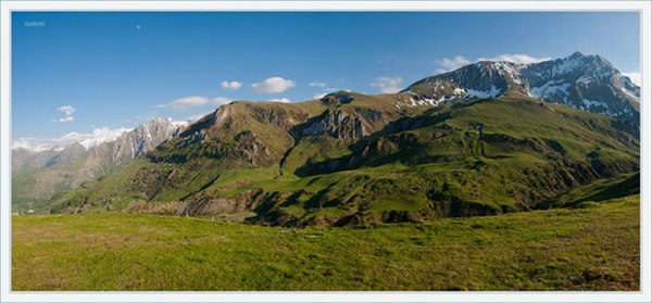
high knobs on a rounded ridge. Col de Soulor may be only a shoulder point to Col
d'Aubisque, but it is the perfect vantage point on
the best part of this ride. In appreciation of
this perfect location, there are several picnic
tables on a knoll above the pass, a number of
information tablets, even a small bar or
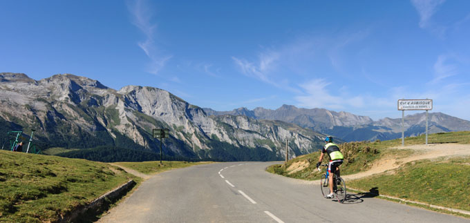
restaurant. Ahead you can see the road to Col d'Aubisque
traverse along a rock face of a very steep ridge,
the Cirque de Litor. It is just above treeline and
contains exposed rock cuts. There is a small
descent to a low point between the two passes. It
amounts to a little over 100 meters. For the
purposes of these pages I'll call Col du Soulor a
shoulder point to Col d'Aubisque. At the low point
between the two are two tunnels, that I remember
as fairly rough and wet. Crossing over a small
stream at the low point marks the transition from
the Haute Pyrenees to the wetter Atlantic
Pyrenees. On this traverse the cyclists I see,
outnumber cars by a wide margin. The ones going up
to Aubisque don't ride very close to the edge of
the road. I myself sometimes ride on the left to
avoid getting too close to the dropoff. This is a
very exposed road with vertical cliffs below.
Falling off the bike may involve a much larger
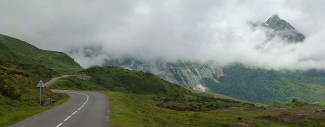
height than just the height of the bike itself. Another interesting scene is the birdseye view of
the other approach of Col du Soulor, cutting
across the top of green triangular mountain with a
straight line roadcut. The climb to the top of Col
d'Aubisque finishes as a long meandering set of
curves above treeline on gentle tundra slope - a
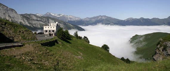
gentle finish to a harsh climb. The summit house
comes into sight a couple of km before getting
there.
The top has quite a circus atmosphere, and
absolutely everybody has to stop here, including
plenty of motorcyclists. Partly the reason for
this is the summit house, partly it's the set of
gigantic stick bicycles, set up on the summit.
Never mind the scenery. The most pictures taken
here, are of each other doing acrobatics on these
bicycle props that don't move. At least that's the
impression I get from my visit, and the numerous
pictures of this on the web confirm it. You see
these oversized stick bicycles in many French
locations. But here they are especially numerous,
even bigger and supremely strategically located.
People of all persuasions, including
motorcyclists, are prone to climb them and have
their picture taken while hanging meters above the
ground from a handlebar. Among the many cyclists I
come in contact with here, are also two world
cycling girls from New Zealand. We exchange
pictures and cameras.
From East. By the time
I leave the summit, the afternoon light has become
hazy and almost flat. A few rays are still making
shadows. This seems to be a common occurrence. I
am now in the wetter Atlantic Pyrenees. Across
from the Col d'Aubisqe, towards the slope on the
Spanish border, I see a large number of steep
switchbacks climbing up the opposite hill. That
looks like quite a mountain bike ride. But from
the map it appears to be just a ski area access
road. A long enjoyable road above treeline on
relatively gentle rolling tundra with magnificent
far views waits on this side. A restaurant or inn
of some sort clings to one of the few cliffs in
this landscape. The road winds down to an
on-first-view incredibly ugly, industrial strength
ski area, Gourette. But I suppose if you learned
to ski here and are now a world class skier you
have reason to find the place understandably
beautiful, Then follows a long descent through the
forest.
But the most interesting town of all is still
ahead, an old elegant spa resort by the name of
Eax-Bonnes. The road goes through its center, a
series of elegant old hotels around an elongated
park that also makes a traffic circle.
Unfortunately it is too late for me to spend much
time here to look around and see what is open.
Maybe some other time. More rolling is to be done from here, but brakes
become optional. Before reaching Laruns, the road
makes a right angle turn to traverse above it,
apparently just to show it off. I get lost in this
town for a while. Picking up the main road again,
it is now normal, wide and modern highway the rest
of the way to Arudy. The map also shows a small
side road alternative on the other side of the
river, that may be a more interesting ride. History Cycling-Tour de France. Since 1947, the
Tour has crossed the pass 45 times (current to
2016). This is the second most often crossed pass
by this race for that time period. The first
crossing took place in 1910, also the first year
that the race entered high mountains for the first
time. That year Col d'Aubisque was cleared of snow
specifically for the race. But the surface below
remained unpaved. During that monstrous 326km
stage, it was the last of 4 passes on a stage from
Bagneres-de-Luchon to Bayonne. The others were Peyresroude, Aspin and Tourmalet.
Octave Lapize won that stage and is said to have
walked a part of the Aubisque approach. These four
passes continue to this day to be the four most
famous Pyrenean cycling passes. Stories of snow
and crashes on a snowy road persist through the
years. In 2016 a stage of the Vuelta d'Espana also
finished on top of the pass.
Dayride with this point as highest summit: COMPLETELY PAVED: ( < Col du Tourmalet | Col de Spandelles > ) Col du Aubisque : Lourdes > bikepath south > Argeles-Gazost > Aucun > Col du Soulou\r(shp) > Col du Aubisque > Eux-Bonnes > Laruns > Gere-Belesten > Louve-Juzon > D35 west > Asson > Lestelle-Betharam > Peyrouse > back to Lourdes (r5:16.4,5) Notes: gps and distance data are on stolen computer ( < Hautacam(ow) | Segus s(u) > ) Col d'Aubisque: Boo-Lilhen > Aucon > Col de Soulor(sh) > Col d'Aubisque > Gourette > Eux Bonnes > Laruns > Louvie-Juzon > Lestelle-Betharam > Lourdes > bikepath back to starting point in Boo-Silhen with grocery shopping Notes: same ride as the one 3 years earlier, but different starting point with a short additional out and back - even better weather than before - finally got to look around Eaux-Bonnes History Cycling - Tour de France: This summit has been on a Tour de France stage an incredible 48 times, which should ensure that it remains amongst the top 3 most popular passes with route planners for the Tour de France - or a Holiday bike tour for that matter, for decades to come. The first time it appeared in the race was jsut at the beginning of the post WW2 in 1947. Surprisingly Pau is the most popular anchor point, outnumbering tourist bases for vacation cycling, such as Lourdes (used five times), Argeles-Gazost (used only once), and Bagnere de Bigorre (four times), and (Bagneres de) Luchon used eleven times (as of 2019). |
|
|
advertisement |
|
|
advertisement |