| |
| |
Cormet de Roselend
This pass road seems
to be on many favorite lists. It is the closest
paved road to the west side of the Mont Blanc
Massif, but you only catch a view of it at one
particular place. On the other side of the pass is
the lower Beaufontain group of mountains. This
road stays above treeline for a long time. On both
sides approaches lead through deep glacially cut
gorges.
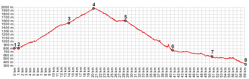
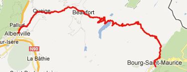
From South. Three pass roads converge in Bourg St Maurice, Kleiner Sankt Bernhard Pass (Col du Petit St Bernard), Col d'Isere and Cormet de Roselend. Unlike the other two, the approach to Cormet de Roselend starts climbing immediately upon leaving the roundabout outside town, and enters the massive gorge of the Versoyen. Framed by a V made of trees and rocks, a snowy peak on the south of N90 slowly grows in posture as the road rises. That was only the first part of the workout. The road levels out a bit and enters a high alpine valley, still with vertical walls. Another ice dissected peak manages to creep into view at the head of a valley on the right side at "les Chapieux". There is a junction with a dirt road and this is also the site of a fairly primitive looking, but expensive auberge. The pressures of tourism here may be higher than first suspected. Surprise - the ice dissected peak is really a flank of Mont Blanc. Now the "pressures of tourism" part starts to make sense too. Continuing past les Chapieux, the road turns east
and climbs a breadloaf shaped mass far above
treeline. The top is a wide tundra gap with the
most impressive peaks on the south side, Aguile de
Grand Fond. Surprisingly all the peaks in that
group are still well below 3000m. On top of the
pass is a small parking lot and maybe a portable
souvenir/ham shop.
From North. (described downwards) This side is not quite as stark looking, but maybe even more scenic. You can see various block shaped mountains in the distance falling away like a staircase. After the road passes two restaurants it descends to the Roselend Reservoir. Unless it's getting late too early, this is a chance to relax (from the strenuous downhill). The road makes its way to a picturesque chapel opposite a waterfall on the opposite side of the lake. It's almost a little too picturesque. It looks like it has been put up just for photgraphic purposes. In a way it was, and in another way it was not. It is a reconstruction of a chapel that was submerged in the reservoir. The reconstruction is authentic but the location appears contrived. Just when leaving the lake the road passes a
point labeled "Col de Maraillet" on the map. It is
a shoulder point on the paved route, and I can't
find a second approach to this pass on the map, so
it remains somewhat of a mystery. Historical Notes Before the reservoir came the town.
The town of Roselend was already a tourist
destination. It had three hotes for wealthy
tourists. Between the time that the land for the
damn was sold, to the time that the damn was
actually filled to maximum capacity with water, 29
years passed (1949-1978). Prior to this major
water storage facility, there was already a
smaller reservoir at this location. Cycling - Tour de France: The
race crossed the summit 10 times between 1979 and
2009. A day on an extended tour: (<Col de la Madeleine|>)
Cormet de Roselend: Aime > Bourg St Maurice > Cormet de Roselend > Beaufort > Queige: 51.8miles with 5190ft of climbing in 5:21hrs (VDO MC1.0 m4:12.6.18) Dayrides from
the endpoint on this day, Queige, are on page:
Cormet d'Areches Col de l'Arpettaz Col des Saises Colle de Tamie
|
 Approaches
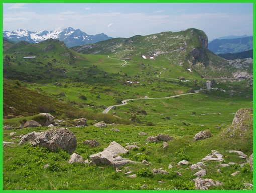
|
|
advertisement |
|
|
advertisement |