| |
| |
Col de la Madeleine
There are two big,
famous, relentless (add you favorite superlative
to this list) cycling passes, that connect the
valleys of the Maurienne with the valley of the
Tarentainse, the Col
d'Isere and the Col de la Madeleine. You
might expect that both of these passes would be
favorites on the Tour de France, not only because
of the cycling and the scenery, but also the
presence of large, developed ski towns which can
accommodate all the race caravans.
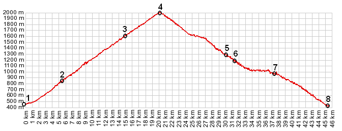
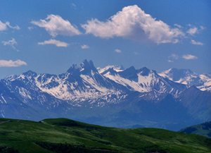
Actually the Col de la Madeleine has been on the route 26 times, while the Col de l'iseran has only been on the route 4 times (up to 2012). Maybe the reason are the nearby Col du Glandon combined with the Col de la Croix de Fere. One after the other makes for a really massive climbing race. The really unforgettable thing about this pass, at least during good weather, is a great far view of Mont Blanc. Seen from this vantage point, this is about as much vertical relief, as you can find on any mountain vista in the alps.
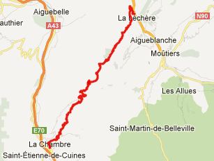
From South. When leaving la Chambre,
there is a road cut visible on the opposite
mountain to the north, that you can't help but
notice. That's an alternate lower approach to this
pass, the Montvernier Road, contains a short
distance of unpaved road. But this profile takes
the more direct route on the main road, and it
will take a long hard climb to reach the altitude,
that the other road across the valley has reached
already. This side of the pass can be a fairly
busy road. Not until the climb passes through the
condominium towers of the ski area (and has merged
with the alternate approach), does traffic quiet
down a little bit. Now there is more peace to
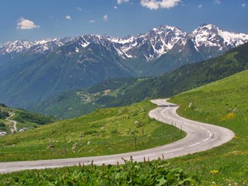
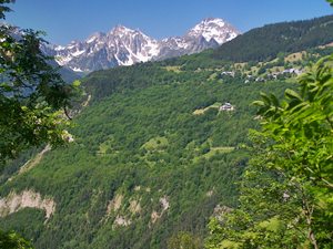
enjoy the far view of the les Aigles s'Arves,
three horns that stick out of the landscape like
horns on rhinoceros. These would be the greatest
view to remember, if it were not for another scene
that emerges at the top, the view of Mont Blanc. From North. (described downwards). This
side seems to be a lot quieter, as far as traffic
is concerned, and the road shows no signs of
becoming busier as it approaches the valley.
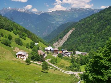
Further up two picturesque old villages,
containing only very few modern buildings, line
the hillside. Finally the road traverses down the
wooded slopes of the Chaine de la Lauziere to meet
the river Eau Rousse.
A few historical notes
Like with all major passes in the alps, early history is a little fuzzy, except for on thing, these routes have been used for a very long time. Already in the 18th century, the pass was a destination for what you might call religious tourism ( there is a word for that - pilgrimage) They came here to visit a chapel, dedicated to Sainte Madaleine. The road across the pass has a much more recent history, especially compared with nearby passes - and it's still a long history in a way. Between the decision to build a road across the pass and the actual completion, 20 years passed: 1949 to 1969. History-Cycling: Right from its very beginning the history of the road is tied up with the history of the Tour de France. In road was inaugurated by a stage of the 56th running of the famous race on a stage between Chamonix and Briancon. Between then and 2012 this stage route was never repeated. In fact the race seems to find a new route for the day containing the pass, more often than not. That first year the tour was won by Eddy Merckx, but the leader at the time this pass was crossed was the Spaniard Andre Gandarias. This section of the race quickly got the reputation as one of the hardest mountain sections, in combination with adjacent stages over Col de Telegraphe and Col du Galibier. In 2005 the Tour de France crossed Col de Madeleine for the 25th time. A day on an
extended tour: (<Col du Glandon|Cormet de Roselend>)
|
 Approaches
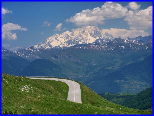
|
|
advertisement |
|
|
advertisement |