| |
| |
Col de Ibarburua via D417
s(u)
This pass accesses a high grazing
area west of St-Jean-Pied-de-Port. From some of
the other rides in this area, you may have noticed
the striking striking geologic structure and
scenery of this location. It is an outcropping
geosyncline, that makes a memorable landmark from
the Col de
Burdincurutcheta (for example). A view from
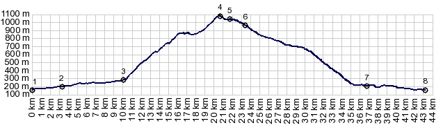
there is worth a million words. Several pass names are marked on the
map in this general area, where three paved
approaches meet and one partially unpaved
approach. This particular point is on D417, south
of what is actually marked as Col de Ibarburua.
Other points within 40m of elevation are Col de
Aphinaze (always just a shoulder point, no matter
how you approach it), Col de Landerre, about 1072m
and the highest point if approaching via D117, and
Col de Burdin Olatze on the direct appraoch from
Col de Iraty. The spot marked as Col de Ibarburua
itself is at 966m and part of the northern
approach of the profile.
The pass starts out with its absolutely steepest
part, inconspicuously located between a couple of
houses and vertical appearing driveways. It
doesn't last long. It is just there to leave a
lasting initial impression, like the the firm
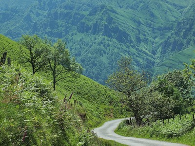
handshake on a first business meeting. After that, climbing continues to be a major
workout, but the scenery dominates in the mind.
Soon above treeline, there are views of a village
to the north, underlined by a sweeping S shape of
trees, separating two grazing meadows. On the
other side of the valley, Col de
Burdinkurutchetna climbs more spectacularly
than imagined, if you one have descended that same
road (I did several days earlier). The road to
Ibarburua aims for a shallow saddle in this large
gentle geosyncline of limestone outcrops. The top
makes a last steep effort to gain the gentle ridge
with a grand view on ranges south
The roll down the north side is fast and scenic,
not one of those break pad screeching, million
turns a second affairs, like the passes to the
south of here. You actually get somewhere on the
map quickly by just letting it roll. The view now
takes in the snow covered mountains behind Port de Larrau,
including the cone shaped Pic d'Orry, a quickly
recognized landmark at just over 2000m. After the
panorama show, a fast descend on a wider road
leads back down into the summer heat and normal
traffic on D318.
Dayride with this point as highest elevation: COMPLETELY PAVED ( < Col de Arnosteguy | Col de Ibaneta > ) Col de Ibarburua , Col de Gamia / Azkonzabai , Col de Osquich : St Jean Pied de Port > Mendive > Col de Ibarburua s(u) <> out and back west past summit of cd Aphanize >> Aussurucq > Garindein > Musculdy > Col de Osquich > Ibarolle > Col de Gamia/ Azkonzabai > back to strating point in St Jean Pied de Port: 57.0m with 6356ft of climbing in 5:48hrs (garmin etrex30 r5:19.6.17). |
|
|
advertisement |
|
|
advertisement |