| |
| |
Port de Larrau
This is an infamously steep climb in
the Pyrenees. The "steep" part refers only to the
French side. The fame persists in spite of the
fact, that the pass was only used twice in the
Tour de France. The landscape does not seem to
justify this long steep climb. There are no
vertical rock walls and dagger like peaks. But
this route has a another way to stick in one's
memory, partly for its steepness, and partly for
the expansive sweeping tundra slopes between Col
d'Erroymendi on the French side and the summit
tunnel on the Spanish side. The summit is located
below Pic Orhi, with 2017m the most westerly peak
above 2000m in the Pyrennees.
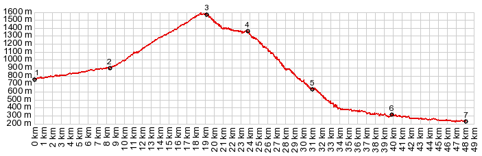
Approaches No matter how you approach, it gets steeper here
(at point 2). When the road finally gets above
treeline, the top of the landscape dissolves into
mist. But as time goes on, the fog clears, and the
road looks out over an enormous green loaf shapes.
The most impressive view is to the south onto a
ridge that seems to run like a vertebrae,
perpendicular to the spine of the Pyrenees. On top
is a medium length straight tunnel. On the other
side the view opens onto a long traverse through
the upper part of a big tundra bowl.
The village Larrau marks the transition to the
second part of this profile. For a while grassy
slopes replace the forest next to the road. Soon a
small inconspicuous sign points down a narrow
bumpy road, the way to Col Bagargui,
another one of those deceptively steep, little
roads in the French Pyrenees. Looking back on the
route behind, a green ridge begins to look like a
moss covered ship hull, turned upside down from
this vantage point. An especially steep section starts, where several
switchbacks precede a reentry into the forest.
These switchbacks do not actually go up a steep
cliff, but give more the appearance of swinging
curves up a regular green hill. A small parking
lot invites to study the trace of Col de Bagarrgui
on the opposite ridge, and also an opportunity to
rest. The next section in dense forest seems like
the steepest to me, with few turns and no views to
let the mind wander.
Cycling-Tour de France: As already
mentioned, up to 2014 this summit has been only
twice on the route of the Tour de France, 1996 and
2007. The 1996 stage over this pass is often cited
for Miguel Induran's last mountain stage ever.
This was close to his home territory and a
considerable loss of time during the climb was a
disappointment for him.
Dayride with this point as highest summit: COMPLETELY PAVED: ( < Col
de la Pierre Saint-Martin | Alto de Zuriza s(u)
> ) A Dayride with this point as intermediate
summit is on page: Col de la
Pierre St-Martin  |
 From North. (also
described upwards). When turning onto the profile
at point 6, this road is a quiet peaceful curving
road through the forest. The only sounds come from
the stream Le Saison. Around Laguinge-Restoue many
parked cars on the side of the road are evidence
of the hikers in the nearby green canyons, and
also of the delicious food, that is being served
in roadside restaurants, on this weekend that I am
passing through here.
From North. (also
described upwards). When turning onto the profile
at point 6, this road is a quiet peaceful curving
road through the forest. The only sounds come from
the stream Le Saison. Around Laguinge-Restoue many
parked cars on the side of the road are evidence
of the hikers in the nearby green canyons, and
also of the delicious food, that is being served
in roadside restaurants, on this weekend that I am
passing through here. When the road finally
climbs above treeline much of the work is over,
but a few of the steepest, very short sections
remain. It seems like somebody wanted to construct
a straight road up the mountain, rather than with
curvy steepness mitigation efforts. What looks
like the summit from below, is really Col
d'Erroymendi, not a pass or summit at all as far
as the road is concerned. But it is the first
truly alpine and spectacular view along the
entire journey. Much of the work is over and
most of the scenery and pleasure is ahead. The
road traverses along a big tundra bowl. Port de
Larrau is not far away, but getting there takes
longer than expected, because of the curvy detours
back into the flowing mountainscape, made up of
adjoining tundra amphitheaters. As a final workout
several regular straight ramps lead up to the true
summit. Here a rustic, in my case always
completely empty dirt parking lot, with a number
of old signs serve as stageset for summit
photographs.
When the road finally
climbs above treeline much of the work is over,
but a few of the steepest, very short sections
remain. It seems like somebody wanted to construct
a straight road up the mountain, rather than with
curvy steepness mitigation efforts. What looks
like the summit from below, is really Col
d'Erroymendi, not a pass or summit at all as far
as the road is concerned. But it is the first
truly alpine and spectacular view along the
entire journey. Much of the work is over and
most of the scenery and pleasure is ahead. The
road traverses along a big tundra bowl. Port de
Larrau is not far away, but getting there takes
longer than expected, because of the curvy detours
back into the flowing mountainscape, made up of
adjoining tundra amphitheaters. As a final workout
several regular straight ramps lead up to the true
summit. Here a rustic, in my case always
completely empty dirt parking lot, with a number
of old signs serve as stageset for summit
photographs. |
|
advertisement |
|
|
advertisement |