| |
| |
Col d'Arnosteguy
Looking at a 1:200 000 scale map of
the passes and summits south of
St-Jean-de-Pied-de-Port can be misleading. It's
easy to miss a squiggle or two, or maybe the
mapmakers missed them. This squiggle or two in
reality can take half a day to climb up. This pass
one of those combination of squiggles. The main purpose of this road, and
many others in this area appears to be, for Basque
herders to be able to access vast, open, high
grazing areas. These roads often are narrow as a
bike path, but paved. They avoid any expensive
road building measures such as road cuts. They
often start impossibly steep and then above
treeline meander around the mountain, only to
reach an unsigned pass, that may or may not be the
highest point on the profile. Often there are
other passes nearby, that are within very short
distance of the road pass in question. Names can
also be confusing because of spelling variations
in different languages.
But the surface is impeccably smooth pavement,
even if there is not that much of it, because the
road is pretty narrow. D429 is signed as the
Camino de Compostella de Santiago, starting right
at the southern towngate of
St-Jean-de-Pied-de-Port. My bicycle hardly moves
faster than the pilgrims are walking, and much of
the way, I am actually walking too. It is a busy
pilgrimage this morning. It has been rainy over
the last two days and today is impeccable clear
sunshine, which is appreciated by hikers and
cyclist equally. There is a backlog of Santiago de
Compostella bound trail traffic. Starting at the bottom, there is also an option
to detour the pilgrim route by connection to
points east over D128 and then go over Arnosteguy.
For repeated training rides this is probably an
attractive option to walk less, and bike more. As the little curvy road climbs steeply, always
following the land, never the slightest roadcut,
the lush green surroundings of St Jean move in
perspective. It is not lush in a tropical sense.
Trees are loners up here. There canopies and their
shape are not lost in the crowd of the forest. But
their shape helps determine the character of the
landscape. But the pallouse is lush - a green
carpet emulating the yellow of the sun in
intensity. This lawn of the landscape is
perpetually kept at bay by thousands of sheep
dotting the landscape. As the road climbs the dots
become smaller, also more numerous, more
spectacular in their entirety, the way they
control the landscape, just by being in all the
right places and eating it.
The pass is very close. Now far above treeline,
the mountains are green faces with small limestone
outcrops, providing a kind of background texture.
The hard work is over. The road traverses along a
bowl, containing another group of landscape
controlling sheep. The pass opens up a view into Spain and far snow
covered mountains to the west. In addition to the
road, there is also a trail that can be seen,
descending and then climbing again on the Spanish
side. It looks mountain bikable. But the profile
stays on French pavement. It does not actually
cross the pass, but descends another way on the
north east side.
From North-2. (described
downwards) After a look at the sheep bowl from the
opposite side - it looks just as scenic but with
different background - the road descends to a
herding area - still above treeline. A
conversation with a spanish driver leads me to the
conclusion that I have to descend much further to
follow my route. There are no roadsigns for these
roads close to the spanish border, but a map
suggests that much of this is mountain bikable
terrain with descends into Spain possible. The paved Iraty bound road descends steeply in
long forest ramps. But first there is an
impressive panorama of a wild green peak. I think
it is Errozate, and from this side you would be
hard pressed to believe, that a road comes close
to the top from the other side. After a brake
screeching descend, Past a restauraunt, another
equally narrow lonesome road climbs to the next
summit Arthaburo s(u). But the profile descends
all the way back down to St Jean.
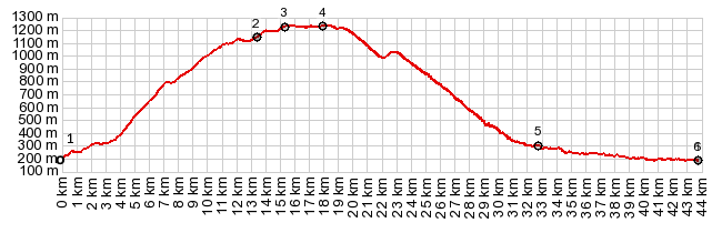
Dayride with this point as highest summit: COMPLETELY PAVED ( < Cirque de Troumouse(ow) | Col de Ibarburua > ) Col de Arnosteguy , Arthaburo s(u) , Col de Burdincurutcheta , Col de Zurtzai , additional out and back: St Jean Pied de Port > D428 south > Col de Arnosteguy > Arthaburo s(u) <> out and back to turnaround point, just past highest point on Errotzate s(u) >> D301 east > Col de Zurzai > Chalet de Irati > Col de Burdincurutcheta > Mendive > back to starting point in St Jean Pied de Port: 52.6miles with 8761ft of climbing in 6:35hrs (garmin etrex30: r5:19.6.16) Notes: Col de Zurtzai would have greater than 500ft climbs on two sides, if approaches from Spain and the dead end below Chalet de Irati |
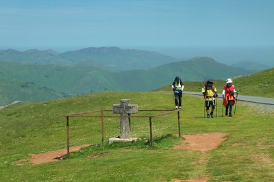 The same way the Mormons parted
way with the California miners on the Oregon
Trail, there is also a parting of the ways between
the hikers and the handful of bikers. It happens
at a simple fenced off cross, and very close to
the Spanish border. But the border pass will be a
different one for each category of traveler.
The same way the Mormons parted
way with the California miners on the Oregon
Trail, there is also a parting of the ways between
the hikers and the handful of bikers. It happens
at a simple fenced off cross, and very close to
the Spanish border. But the border pass will be a
different one for each category of traveler.|
|
advertisement |
|
|
advertisement |