| |
|
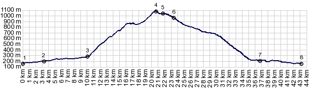
1.(00.0km,0160m)START-END WEST:low point
in St Jead Pied de Port
2.(03.3km,0200m)profile turns right onto D18
3.(10.0km,0280m)profile turns left onto D417
4.(20.6km,1080m)TOP:highest point Col de Ibarburua s(u)
5.(21.8km,1040m)turnoff to Col de Aphanize, just before
Cd Inharpu
6.(23.4km,0970m)jct with road south at Cd Ibarburua
7.(36.7km,0240m)Aussurruzq
8.(43.2km,0180m)START-END EAST: jct with D918 west of
Mauleon-Licharre
|